YB-49 Crash Site

The YB-49 was a prototype jet-powered flying wing aircraft designed and built by Northrop Corporation in the 1940s and 1950s. On June 5, 1948, the YB-49 experienced a catastrophic crash near Mojave in Los Angeles County, California, which resulted in the death of all five crew members on board. Captain Glen Edwards was the co-pilot of the flight, and the namesake of Edwards Air Force Base. The crash was a significant event in aviation history, as it raised questions about the safety of experimental aircraft and the future of jet-powered flight.

On June 5, 1948, the YB-49 experienced a catastrophic crash that resulted in the death of all five crew members on board.

The YB-49 was designed as a successor to the earlier Northrop XB-35 flying wing bomber, which had been developed during World War II. The YB-49 was a radical departure from traditional aircraft design, with no tail or fuselage and a single large wing that housed the crew, engines, and weapons. The aircraft was powered by eight General Electric J35 turbojet engines and was capable of speeds up to 500 miles per hour and altitudes up to 40,000 feet.

On the day of the crash, the YB-49 took off from Muroc Air Force Base in California for a test flight. The flight was routine until about an hour into the flight, when the aircraft suddenly went into an uncontrolled spin and crashed into the desert floor. The cause of the crash was later determined to be a malfunction in the aircraft’s flight control system, which caused the elevons (the wing-mounted control surfaces that control pitch and roll) to become stuck in a partially raised position. This caused the aircraft to become unstable and enter the spin.

Brave Men Lost

The crash of the YB-49 cost these men their lives:

  • Major Daniel H. Forbes, Jr. – Pilot
  • Captain Glen W. Edwards – Copilot
  • Lt. Edward L. Swindell – Flight Engineer
  • Clare C. Lesser – Air Force civilian engineers
  • Charles H. LaFountain – Air Force civilian engineers

Muroc AFB was renamed Edwards AFB on December 5, 1949 in honor of the late Capt. Glen W Edwards

The crash of the YB-49 was a major setback for Northrop Corporation, which had invested significant time and resources into the development of the flying wing design. It also raised concerns about the safety of experimental aircraft and the need for more rigorous testing and evaluation of new designs before they are put into service. In the years following the crash, Northrop continued to develop and refine the flying wing design, eventually leading to the development of the B-2 stealth bomber, which entered service with the U.S. Air Force in the 1990s.

The crash of the YB-49 was a tragic event that highlighted the risks and challenges of experimental aircraft design. However, it also spurred innovation and development in the aviation industry, leading to the creation of new and advanced aircraft designs that continue to shape the field of aviation today.

YB-49 Crash Site Location summary

NameYB-49 Crash Site
LocationMojave Desert, Los Angeles County, California
Latitude, Longitude35.04243, -117.9926

YB-49 Trail Map

The YB-49 came to rest East of Mojave just North of Highway 58. The site contains a small memorial and one should remember that this is the location of the deaths of five brave men.

References

Fort Ruby

Fort Ruby, also known as Camp Ruby is an old U. S. Army post which was built in 1862 during the American Civil War, The post is located in the “wilderness of eastern Nevada.” and protected the overland mail coaches and Pony Express, in order to maintain links and communication between residents of California and the Union states to the East.

Photo of Fort Ruby as it appeared in 1868, when famed western photographer Timothy Sullivan captured this image.

The fort operated from 1862 to 1869 and was a small outpost in the land of the Western Shoshone tribes. The outpost is built prior to the signing of the Treaty of Ruby Valley in which the United States and the Western Shoshone agreed to allow access and mineral rights to the land in exchange for $5,000 a year for twenty years. These payments was supposed to be delivered in goods and livestock for the tribe. Sadly, only the first payment is delivered.

“Ruby Valley is a bleak, inhospitable place — no forage, nor lumber to build with, and as far as the Indians are concerned, entirely unnecessary to keep troops there,” 

Col. Patrick E. Conner

Col. Patrick E. Conner lead the expedition to the site in 1862 and along with 600 men from the 3rd Regiment of California Volunteers, built the fort from stone and wood from the nearby mountains. Fort Ruby was comprised of fourteen buildings including living quarters, stables, corrals and store houses. Water is supplied by the Fort Ruby Spring located close to the fort. Just one month after initial construction of the fort, the men prepared the fort for winter. Upon doing so, the majority of the soldiers packed up and left for Salt Lake City to establish Fort Douglas. In 1864, the California troops were replaced by the Nevada Volunteers, Company B, 1st Nevada Infantry.

The outpost is located in a vast remote location about halfway between Carson City, Nevada and Salt Lake City Utah. The main threat to the men after the treaty is boredom. Aside from a brief action known as the Goshute War with the local natives, there is nothing for the Troops to keep busy after the treaty is signed.

The camp is decommissioned on September 20th, 1869. As the troops left the outpost, ranch families waved goodbye. Fort Ruby and its soldiers had become a welcome part of the valley. the closing of the fort was a social and economic blow to the local ranchers.

Fort Ruby was salvaged by local ranchers and today, no much remains at the site aside from several graves and a historic marker.

Fort Ruby Summary

NameFort Ruby
LocationWhite Pine County, Nevada
Also Known AsCamp Ruby, Old Camp Ruby, Old Fort Ruby
Latitude, Longitude40.0677778, -115.5294444
GNIS1681469
Elevation1826 meters / 5991 feet
National Historic Landmark66000460

Fort Ruby Map

Resources

Fort Churchill Nevada

Fort Churchill is a Civil War era United States Army Fort, Pony Express Station and overland stage stop located in Lyon County, Nevada just West of Buckland’s Station. The station is designated as a home station, where extra horses, firearms, men and provision are kept. The fort was commissioned to protect early settlers from the east from Indian attacks. The garrison was the largest, most elaborate fortification in the Nevada Territory at the time.

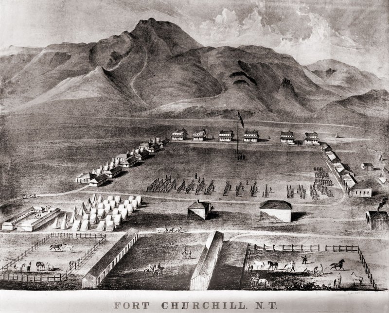
A lithograph drawing of Fort Chuchill, Nevada Territory created by Grafton Tyler Brown in 1862

The discovery of gold in California caused a massive rush of people across the United States. Some of these early settlers came into the Nevada Territory and setup stage stops and mining operations. The arrival of settlers in their territory threatened the the Northern Paiute people. The increase populations of settlers increased the competition for local resources, such as game. These tensions, along with kidnapping and of rape of two young Paiute girls by prospectors from Williams Station erupted into Pyramid Lake War in 1860.

The U.S. Army fort was build along the Carson River and construction of Fort Churchill started on July 20, 1860. The base was named in honor of Sylvester Churchill who was the Inspector General of the Army. The fort is completed in early 1861 and home to some 200 soldiers charged with protecting settlers and mail routes. The post is abandoned in 1869.

On October 6, 1932, Nevada took control of the 200 acre fort and took steps to preserve the ruins as a state park.

Pony Express

Sources generally agree on the identity of Fort Churchill as a Pony Express stop. Built during the summer of 1860 by Captain Joseph Stewart and his men, the adobe fort housed the Pony Express station in its headquarters building. Construction on the fort began on July 20, 1860, approximately twenty-five miles from Comstock, Nevada, along the edge of the Carson River. When Richard Burton arrived at Fort Churchill on October 19, 1860, he gave it a positive review in his journal and named Captain F.F. Flint as the commander.

Since the Pony Express used Buckland’s as a home station, Fort Churchill probably assumed a similar function when the Pony Express transferred its station from Buckland’s to the fort. The Fort Churchill’s ruins existed as late as 1979, including the headquarters building, and it is a Nevada state park. 

Fort Churchill Map

NameFort Churchill
LocationChurchill County, Nevada
Other NamesFort Churchill Station
NPS Pony Express Station153
Next Westbound StationFairview Station
Next Eastbound StationBuckland’s Station
National Historic Landmark66000456

References

Camp Rock Springs

A small oasis and valuable water supply along the Old Mojave Road, Camp Rock Springs was the site of a military outpost established on December 30, 1866.  There are few remains or ruins of the old dusty outpost but a plaque to remind the visitors that men of the U.S. Army served at this remote desert post.

Camp Rock Springs, Old Mojave Road

Camp Rock Springs

To the United States Soldiers of Camp

Rock Springs— who guarded the U.S. Mail.

No Glory there nor much chance for

military fame, but true patriots and heroes

were they, to submit to such privations–

Yet there are the nurseries of the army,

and from such hard schools we graduated

a grant and Sherman, Sheridan and Thomas.

General James F. Rusling USA

Bill Holcomb Chapter

E. Clampus Vitus

The sentiment of General Rusling is poignant, and the soldiers who guarded this post did so without notice from the outside world.  Few people at the time, yet alone now even knew this place existed.  Beginning in 1860 a 20 man patrol, with one officer would patrol between Camp Rock Springs and Fort Mojave to the East, twice per month, every month, to maintain and service the Mojave Road.

In 1863, a number of complaints were filed with the army recording Indian sightings and activity including 300 – 400 encamped about 30 miles to the south.  Additionally there were complaints the Native Americans were thought to be steeling cattle, however these complaints were cancelled a few days later.  If nothing else, this would seem to indicate a level of contempt and distrust towards the native population regardless, these complaints and issues kept the army in the Mojave desert busy.

Rock Springs
Rock Springs

In 1865, two men started a mining operation at the Rock Springs location.  While the two men were away, their buildings burnt and their supplies stolen.  The two men immediately became very vocal in their complaints that the government was developing the area for the government while not protective the investment of the miners.  Soon after the miners fled the area, Camp Rock Springs became and official post of the army, and is described as  “On the desert . . . very disagreeable place for the troops” in a government report.

The camp was quickly built using local building materials, however the high cost of operating the camp and the scarcity of water, despite the spring, caused the camp to close in 1868.  The duties of Camp Rock were taken over by the Camp at Marl Springs.

Camp Rock Springs
Camp Rock Springs

The site now does still have some water, and is a small oasis in the desert.  The spring does not travel more than 50 feet into the canyon before the desert claims it again.  The Camp, like the soldiers is long gone.