The Leadfiled Chronicle newspaper was published in Leadfield, California, was a short-lived mining town in Titus Canyon, Grapevine Mountains, established in 1925 and abandoned by 1927. Promoted as a prosperous lead and copper mining hub, the town was the product of an elaborate get-rich-quick scheme led by Charles C. Julian and the Western Lead Mines Company. The Leadfield Chronicle, a newspaper launched during the town’s brief boom, served as a promotional tool to attract investors and settlers. This report explores the origins, purpose, and legacy of the Leadfield Chronicle within the context of Leadfield’s fraudulent history.
Background: The Rise of Leadfield

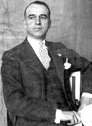
Leadfield emerged during a speculative mining boom in the mid-1920s, capitalizing on the allure of mineral wealth in the Death Valley region. Ore deposits in Titus Canyon had been prospected as early as 1905, but large-scale development began in 1925 under the direction of Charles C. Julian, a Southern California oil promoter with a questionable reputation. Julian’s Western Lead Mines Company aggressively marketed Leadfield as a future mining metropolis, exaggerating the area’s mineral potential through misleading advertisements. Promotional materials depicted steamboats navigating the Amargosa River—a dry riverbed located nearly 20 miles away—to entice investors and settlers.
By January 1926, Leadfield was officially platted with 1,749 lots, and infrastructure developments included 15 miles of road connecting to Beatty, Nevada, a concrete foundation for a stamp mill, and initial power pole installations. The population peaked at approximately 300 residents in 1926, with a post office opening in August of that year. Amid this speculative frenzy, the Leadfield Chronicle was established to bolster the town’s image and sustain investor confidence.
The Leadfield Chronicle: Purpose and Content
The Leadfield Chronicle was launched in March 1926, during the height of Leadfield’s boom. While no surviving copies of the newspaper are widely documented, historical accounts suggest it functioned primarily as a promotional vehicle for the Western Lead Mines Company and Julian’s schemes. The newspaper likely published optimistic reports about the town’s mining prospects, infrastructure developments, and economic potential to maintain enthusiasm among investors and residents.
Headlines from the period, such as one in March 1926 claiming, “Tonnage of ore from new California district will be large,” reflect the hyperbolic tone typical of the Chronicle’s content. Such articles aimed to create an impression of imminent prosperity, despite the lack of substantial ore deposits. The newspaper may have also reported on local developments, such as the construction of a boarding house, water pipelines from a nearby spring, and plans for a 40-room hotel, to portray Leadfield as a thriving community.
Given the fraudulent nature of Leadfield’s promotion, the Chronicle likely omitted or downplayed critical issues, such as Julian’s questionable business practices or the California Corporation Commission’s investigations into the Western Lead Mines Company’s stock sales. The newspaper’s role was to sustain the illusion of a booming town, encouraging further investment and settlement.
The Fall of Leadfield and the Chronicle
Leadfield’s collapse was swift and inevitable. By October 1926, the main tunnel of the Western Lead Mines Company reached its target ledge, revealing negligible high-grade lead ore, contrary to promotional claims. Concurrently, the California Corporation Commission halted stock sales for Julian’s enterprises, including the Western Lead Mines and his backup financing plan, Julian Merger Mines, Inc., due to regulatory violations. These developments triggered a rapid decline in investor confidence.
By February 1927, the Leadfield post office closed, signaling the town’s abandonment. The population, once estimated at 300, dispersed as residents and investors realized the mines’ unprofitability. Charles Julian fled to Oklahoma, later facing fraud charges related to his oil ventures, and ultimately committed suicide in Shanghai in 1934. The Leadfield Chronicle ceased publication with the town’s collapse, leaving no significant archival record due to its brief existence and limited circulation.
Legacy and Historical Significance
The Leadfield Chronicle is a footnote in the broader story of Leadfield’s fraudulent boom, emblematic of the speculative excesses of the 1920s. The newspaper’s role in promoting a fabricated mining bonanza underscores the power of media in shaping perceptions during speculative ventures. While no physical copies of the Chronicle are readily accessible in major archives, such as the California Digital Newspaper Collection or Chronicling America, its mention in historical accounts highlights its function as a tool of deception.
Leadfield itself remains a ghost town, recognized on the National Register of Historic Places since June 10, 1975, for its historical significance as an example of mining fraud. The site, accessible via the rugged Titus Canyon Road, features remnants of wooden and tin buildings, mine shafts, and the stamp mill foundation, serving as a tangible reminder of the town’s brief existence. The Leadfield Chronicle’s legacy lies in its contribution to the myth of Leadfield, a cautionary tale of greed and misrepresentation in the American West.
Conclusion
The Leadfield Chronicle newspaper was a short-lived publication born from the speculative fervor of Leadfield, California, in 1926. As a mouthpiece for Charles C. Julian and the Western Lead Mines Company, it played a critical role in promoting a fraudulent mining boom that collapsed within a year. Though little direct evidence of the newspaper survives, its historical significance lies in its reflection of the era’s get-rich-quick schemes and the role of media in perpetuating them. Leadfield’s story, preserved in the ruins of Titus Canyon and documented in historical records, serves as a testament to the fleeting dreams of prosperity that characterized the 1920s mining frontier.
References
- Western Mining History, “Leadfield California,” accessed via westernmininghistory.com
- Inspired Imperfection, “Leadfield Ghost Town On Titus Canyon Road In Death Valley,” accessed via inspiredimperfection.com
- National Park Service, “Leadfield,” accessed via www.nps.gov
- Walking Wild & Free, “Leadfield – Death Valley National Park,” accessed via www.walkingwildandfree.com
- Digital Desert, “Leadfield Ghost Town,” accessed via digital-desert.com
- The Break of Dawns, “Leadfield Ghost Town in Death Valley, California,” accessed via thebreakofdawns.com


![Photograph of an exterior view of the Leadfield Hotel in Death Valley's Titus Canyon, [s.d.]. The hotel is a simple wooden structure with a slanted roof and a rectangular façade. The upper left corner of the façade is missing, revealing the interior of the building. Three large rectangular windows and two doors alternate across the front of the building. There are three people standing on a caved-in porch in front of the hotel. A large rocky mountain rises up behind the hotel. The hotel was part of C. C. Julian's Leadfield boomtown, the hey day of which was in 1925. Photo Credit “University of Southern California. Libraries” and “California Historical Society” as the source. Digitally reproduced by the USC Digital Library.](https://i0.wp.com/www.destination4x4.com/wp-content/uploads/2022/03/CHS-13040.jpg?ssl=1)