
Clark County offers the explorer an opportunity to explore the Nevadan desert beyond the reach of the bright lights of the Las Vegas strip. The BLM Southern Nevada District Office manages more than three million acres of Mojave Desert in Clark and Nye counties. These trails offer scenery which varies from dramatically colorful geologic land forms and largely unspoiled panoramic vistas of Red Rock Canyon National Conservation Area to remote and rugged wild landscapes of Gold Butte Back Country Byway.

Recreation opportunities abound and viewing sites for desert plants and animals are easily accessible. The Las Vegas and Clark county offers year round 4×4 destinations and trails. In the hot summer months a trail can take you down to the waters edge for a cool swim the Lake Mead, Lake Mojave or the Colorado River itself, while Mount Charleston offer islands in the sky to get above the heat.

Additionally Las Vegas offers a great jump off point for trips into the wilderness including Death Valley National Park and the Mojave Road. On a personal note, you have not lived until you pull into one of the casinos for an overnight, after being out on the trails for a week.
Humboldt–Toiyabe National Forest
Spanning an awe-inspiring 6.3 million acres, Humboldt–Toiyabe National Forest is the largest national forest in the contiguous United States. This vast landscape stretches across most of Nevada and into a portion of eastern California. Unlike traditional forests, it consists of numerous large, non-contiguous sections scattered across dozens of mountain ranges, creating a mosaic of extraordinary natural beauty.
Clark County – Las Vegas Area Map
Clark County 4×4 Trails
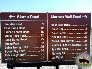 Alamo RoadAlamo Road and parts beyond. Photo by James L Rathbun The Alamo Road is the central route north through the Desert National Wildlife Refuge north… |
 Bitter SpringsBitter Springs is a 28 miles back country road which connects I-15 to the North shore Road highway 167 located inside Lake Mead National Recreation… |
 Burro WashMy one week old, Black Jeep on our first 4x4 trail to Burro Wash This scenic backcountry adventure takes you down Burro Wash into the… |
 Lucy Grey GoldmineThe Lucy Grey Goldmine trail is a short 4x4 trip out of Primm, Nevada up to an old mine site. The route is fairly accessible… |
 Mormon Wells RoadEntering Peek-a-boo Canyon on the Mormon Wells Road. The Mormon Well Road is a long, rough, dirt road that runs across the Desert National Wildlife… |
Nellis CoveNellis Cove Road short east trail from Lake Mead Powerline Road to Nellis Cove on the shore of Lake Mohave, Nevada. The route is fairly… |
 Pine Nut RoadThe turn off to Pine Nut Road off the Mormon Wells Road near Las Vegas, Nevada Pine Nut Road is a 6-mile long, bumpy dirt… |
 Potosi, Nevada – Clark County Ghost TownPotosi (also known as Potosi Camp or Crystal City in the 1870s) is a historic mining ghost town and mining district in Clark County, southern… |
Clark County Ghost Towns
 Bard, Nevada – Clark County Ghost TownGhost towns of Clark County, Nevada Bard, Nevada, is an extinct ghost town and former railroad station located in Clark County in southern Nevada. It… |
 Bonelli’s Ferry, Nevada – Clark County Ghost TownBonelli's Ferry (also known as Old Bonelli Ferry) was a historic Colorado River crossing in Clark County, Nevada, located just above the confluence of the… |
Borax, Nevada – Clark County Ghost TownGhost towns of Clark County, Nevada Borax, Nevada, is a ghost town and former railroad siding in Clark County, in the southern part of the… |
Buster Falls, Nevada – Clark County Ghost TownGhost towns of Clark County, Nevada Buster Falls is a historic ghost town and former mining camp located in El Dorado Canyon (also spelled Eldorado… |
 Callville, Nevada – Colorado River Steamship LandingCallville Nevada is a ghost town and Colorado River Steamboat port, which is now submerged below the waters of Lake Mead. Bishop Anson Call founded… |
Garnet, Nevada – Clark County Ghost TownGhost towns of Clark County, Nevada Garnet is an extinct town, commonly classified as a ghost town, located in Clark County, Nevada, in the United… |
Gold Butte, Nevada – Clark County Ghost TownGhost towns of Clark County, Nevada Gold Butte is a classic Nevada ghost town located in the eastern hook of Clark County, in the rugged… |
Juan, Nevada – Clark County Ghost TownGhost towns of Clark County, Nevada Juan, Nevada, was a minor railroad siding and transient settlement in southeastern Clark County, Nevada, during the early 20th-century… |
 Nelson Nevada and Eldorado Canyon – Clark County Ghost TownNelson, Nevada, is a small unincorporated community in Clark County, located in the rugged hills of El Dorado Canyon about 45 minutes south of Las… |
Potosi, Nevada – Clark County Ghost TownPotosi (also known as Potosi Camp or Crystal City in the 1870s) is a historic mining ghost town and mining district in Clark County, southern… |
Quartette, Nevada – Clark County Ghost TownGhost towns of Clark County, Nevada Quartette, Nevada—also known as Quartette Mill or Quartette Landing—was a short-lived mining settlement and steamboat landing on the west… |
 Rioville, Nevada – Colorado Steamship LandingRioville, Nevada, was a small, short-lived settlement and ferry landing located at the confluence of the Virgin River (also called the Rio Virgin) and the… |
Saint Joseph, Nevada – Clark County Ghost TownGhost towns of Clark County, Nevada Saint Joseph, Nevada, is a historic ghost town located in Clark County in the Moapa Valley along the east… |
Simonsville, Nevada – Clark County Ghost TownGhost towns of Clark County, Nevada Simonsville (occasionally referenced with variant spellings such as Simmonsville) was a short-lived Mormon farming settlement and milling site in… |
 St Thomas Nevada – Clark County Ghost TownFounded in 1865 when Brigham Young sent settles to the confluence of the Virgin River and Muddy Rivers. St Thomas Nevada remained a Mormon settlement until… |
Stone’s Ferry, NevadaGhost towns of Clark County, Nevada Stone's Ferry was a former settlement and Colorado River ferry crossing in Clark County, Nevada, established by members of… |
Historic Markers
 El Dorado Canyon – Nevada State Historic MarkerEl Dorado Canyon NSHM is Nevada State Historical Marker number six and is located in Clark County, Nevada. The stone marker is located on the… |
 Goodsprings Nevada State Historic Marker #102Goodsprings NSHM 20 is Nevada State Historical Marker number one hundred and two and is located in Clark County, Nevada. Goodsprings, Nevada - 1924 Goodsprings,… |
 Gypsum Cave – Nevada State Historical Marker 103Camp of the archaeologists. The Entrance to Gypsum cave is above and to the left of the camp. Desert Magazine, April, 1940 Gypsum Cave, located… |
 Las Vegas and Tonopah RailroadThe Las Vegas and Tonopah Railroad was a standard gauge railroad which operated along 197 miles between the town of Las Vegas and Goldfield, NV.… |
 Nevada Test Site State Historic Marker #165Nevada Test Site NSHM 165 is Nevada State Historical Marker number one hundred and sixty five and is located about 20 miles west of Indian… |
 Old Spanish Trail (Garces Expedition)Old Spanish Trail (Garces Expedition) is a Nevada State Historic Marker Number 140 located in Clark County, Nevada. This marker is one of several which… |
 Old Spanish Trail (Journey of the Dead Man)Old Spanish Trail (Journey of the Dead Man) is a Nevada State Historic Marker Number 139 located in Clark County, Nevada. This marker is one… |
 Old Spanish Trail Mountain Springs Pass – Nevada State Historic MarkerOld Spanish Trail Mountain Springs Pass is located along highway 160 and Nevada State Historic Marker No. 142 in Clark County, Nevada. The Old Spanish… |
 Potosi Nevada State Historic Marker 115Potosi Nevada state historic marker 115 is located along highway 160 between Las Vegas and Pahrump in Clark County. The marker is located off the… |
Potosi, Nevada – Clark County Ghost TownPotosi (also known as Potosi Camp or Crystal City in the 1870s) is a historic mining ghost town and mining district in Clark County, southern… |
 Powell of the Colorado Nevada State Historic Marker 37Powell of the Colorado Nevada State Historic Marker 37 is a marker commemorating the 1869 exploration of the Grand Canyon by Major John Wesley Powell.… |
 Pueblo Grande de NevadaPueblo Grande de Nevada is Nevada State Historic Marker number Forty One and located in Clark County, Nevada. The ruins become to be known as… |
 Searchlight NevadaSearchlight Nevada is a unincorporated town with a history in mining. The small town in Clark County is located south of Las Vegas in Clark… |
 The Camel Corps – Nevada State Historic Marker 104Nevada State Historic Marker no 104 is The Camel Corps located in Clark County Nevada along highway 163 near Laughlin. Sadly, according to the Historic… |
 The Old Spanish Trail 1829-1850 – Nevada State Historic Marker 33Old Spanish Trail 1829-1850 is Nevada State Historic Marker Number 33, located in the town of Blue Diamond, in Clark County, Nevada. The Old Spanish… |
 The Old Spanish Trail 1829-1850 – Nevada State Historic Marker 34Old Spanish Trail 1829-1850 is Nevada State Historic Marker Number 33, located in the town of Mountain Springs, in Clark County, Nevada. Old Spanish Trail… |
Campgrounds
 Boulder Beach CampgroundLake Mead NRA Located within 45 minutes to the Las Vegas strip, Boulder Beach Campground offers a camping opportunity near the shore of beautiful Lake… |
Callville Bay CampgroundLake Mead NRA Named for the now submerged two of Callville, Callville Bay Campground offers a unique and amazing place to strike your camp. The… |
Echo Bay CampgroundLake Mead NRA Echo Bay Campground is located on the shores of the Lake Mead National close to Lake Mead’s Overton Arm and is found… |
Las Vegas Bay CampgroundLake Mead NRA Las Vegas Bay Campground is one of several campgrounds in Lake Mead National Recreation Area and its situation on top of a… |
Nellis CoveNellis Cove Road short east trail from Lake Mead Powerline Road to Nellis Cove on the shore of Lake Mohave, Nevada. The route is fairly… |
Pine Nut RoadThe turn off to Pine Nut Road off the Mormon Wells Road near Las Vegas, Nevada Pine Nut Road is a 6-mile long, bumpy dirt… |
 Red Rock Canyon CampgroundRed Rock Canyon Campground is a stunning and serene camping destination located in Nevada. Nestled in the heart of the Mojave Desert, the campground offers… |
 Sandy WashSandy Wash is a short trail which leads from the Mead Davis Power Line road down to the shore of Lake Mojave, Nevada. We opted… |
Pingback: El Dorado Canyon NSHM - Nevada State Historic Marker - Destination4x4
Pingback: Nevada Test Site NSHM State Historic Marker #165 - Destination4x4
Pingback: Goodsprings NSHM Nevada State Historic Marker #102 - Destination4x4
Pingback: Pueblo Grande de Nevada - Destination4x4
Pingback: Potosi Nevada State Historic Marker 115 - Destination4x4
Pingback: The Camel Corps - Nevada State Historic Marker 104 - Destination4x4
Pingback: Gypsum Cave - Nevada State Historical Marker 103 - Destination4x4
Pingback: Old Spanish Trail - Mountain Springs Pass - Destination4x4
Pingback: Juan Nevada - Clark County Ghost Town - Destination4x4