The “Forging the Link” historical marker in Ely, Nevada, encapsulates the story of a town that became a vital hub in the American West due to its strategic location and economic contributions. The marker, part of Nevada’s historical marker program overseen by the State Historic Preservation Office (SHPO), commemorates Ely’s role in connecting the region through mining, transportation, and community development.

Early Exploration and Mapping (1859)

The story of Ely begins with its placement on the map by James H. Simpson during his 1859 exploration of the Great Basin. As a U.S. Army officer, Simpson conducted surveys to identify potential routes for communication and travel across the vast, arid region. His work highlighted Ely’s strategic position, laying the groundwork for its future development as a regional center. This initial mapping was critical, as it introduced Ely to the broader narrative of westward expansion and connectivity in the United States.
Mining Boom and Economic Growth (1860s–1890s)
In the 1860s, the discovery of silver and gold deposits in the nearby Robinson Mining District spurred interest in the area. These discoveries attracted prospectors and settlers, transforming Ely into a burgeoning hub. By 1887, Ely had grown sufficiently to become the county seat of White Pine County, solidifying its administrative importance. The real economic surge came in the early 1890s with the discovery of significant copper deposits. Copper mining became the backbone of Ely’s economy, drawing investment and labor to the region and necessitating infrastructure to support the industry.
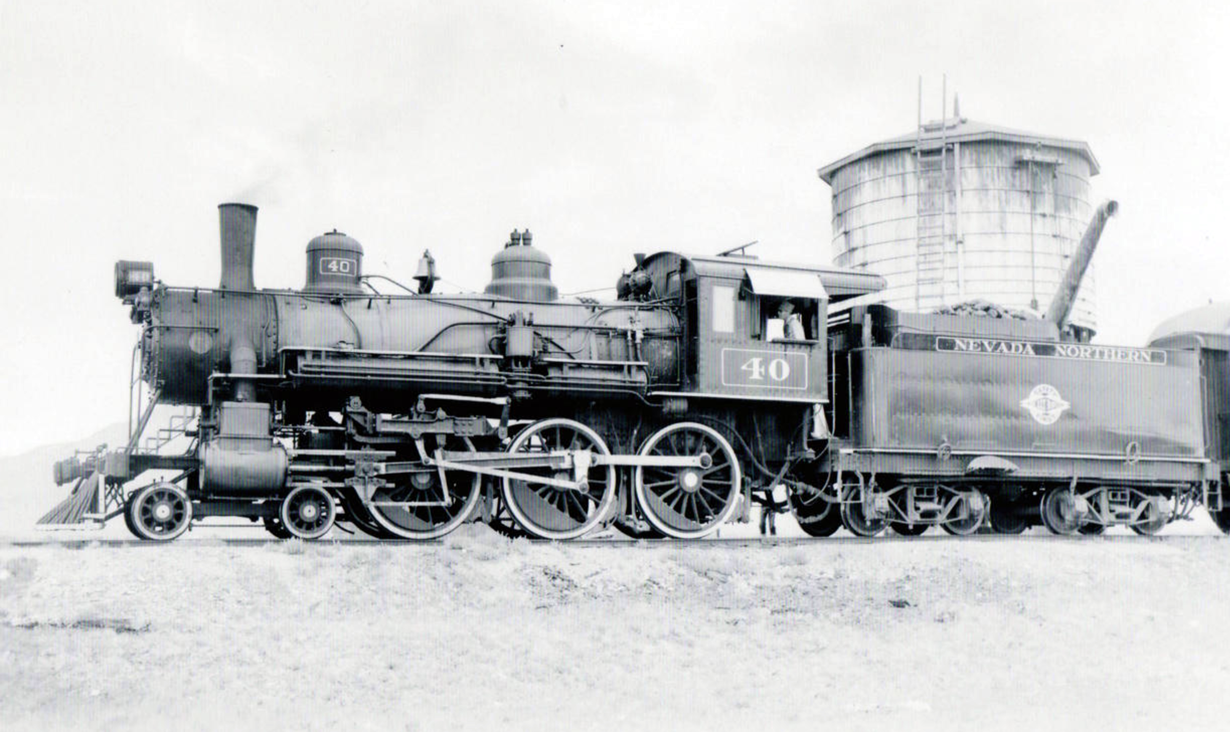
The Nevada Northern Railway (1900s)
A pivotal development in Ely’s history was the establishment of the Nevada Northern Railway, headquartered in East Ely. Completed in the early 20th century, this 150-mile railway connected Ely’s mines in Ruth to a smelter in McGill and linked the town to the transcontinental railroad to the north. The railway was instrumental in transporting copper ore and other goods, effectively “forging the link” between Ely and national markets. This connectivity not only boosted Ely’s economy but also positioned it as a critical node in the supply chain of the American West, facilitating trade and communication across vast distances.

The Lincoln Highway and Road Networks (1913–1922)
Ely’s role as a transportation hub was further cemented in 1913 when the transcontinental Lincoln Highway, one of America’s first coast-to-coast automobile routes, was routed through the town. Although the road was not paved until 1922, its inclusion of Ely underscored the town’s importance as a stopping point for travelers crossing the Great Basin. By the late 19th century, Ely was already connected by a network of wagon roads, but the Lincoln Highway elevated its status. Additionally, two other major roadways—U.S. Route 6 (designated in 1937, formerly the Midland Trail) and U.S. Route 93—converged at Ely, making it a crossroads for travelers moving between Canada, southern California, and beyond. With over 2,000 residents by the early 20th century, Ely offered essential services, making it an ideal stop for weary travelers.
The Historical Marker’s Creation
The “Forging the Link” marker, erected by the Nevada State Historic Preservation Office, was designed to capture Ely’s multifaceted role in connecting the Great Basin through exploration, mining, and transportation. While the exact date of the marker’s installation is not specified in available records, it is part of a broader initiative to document Nevada’s history through physical markers. The marker’s title, “Forging the Link,” reflects Ely’s historical significance as a connector—geographically, economically, and socially—in a region characterized by its isolation.
The marker likely emerged from a collaborative effort involving local historians, community members, and the SHPO, which oversees Nevada’s historical marker program. Such markers are typically proposed by local groups or agencies, such as the Bureau of Land Management’s Ely District, to highlight significant historical narratives. The content of the marker emphasizes Simpson’s exploration, the mining boom, the Nevada Northern Railway, and the Lincoln Highway, weaving together the threads of Ely’s development into a cohesive story of regional importance.
Significance and Legacy
The “Forging the Link” marker serves as both an educational tool and a point of pride for Ely’s residents. It highlights the town’s resilience and adaptability, from its origins as a mapped point in the Great Basin to its growth into a mining and transportation hub. The marker also underscores Ely’s enduring role as a service center for travelers, a legacy that continues with its position at the intersection of major highways. For visitors, the marker offers a glimpse into the challenges and triumphs of life in the American West, particularly in a region as remote as White Pine County.
Today, the marker stands as a testament to Ely’s historical contributions and its ongoing relevance. It invites reflection on how infrastructure and economic activity can transform a small town into a vital link in a larger network, a theme that resonates with Nevada’s broader history of connectivity and development.
James H. Simpson put the future site of Ely on the map during his 1859 exploration through the Great Basin. In the 1860s, silver and gold deposits were discovered nearby in what became the Robinson Mining District. Ely developed as a regional center, becoming the White Pine County seat in 1887. The area grew dramatically in the early 1890s with major copper discoveries. The Nevada Northern Railway, headquartered in East Ely, carried ore from the mines in Ruth to the McGill smelter, as well as connecting Ely to the world on its 150 mile route north to the transcontinental railroad.
The towns of eastern Nevada were joined during the late nineteenth century by a network of wagon roads. In 1913, the road through Ely was incorporated into the transcontinental Lincoln Highway, though it was not paved until 1922. Ely had over 2,000 residents and offered many services, making it an excellent stopping place on the long road across the Great Basin. When the copper industry declined after World War I, the struggling town turned to travelers for income.
The Lincoln Highway was designated U.S. 50 in 1926. By mid-century the popularity of the Victory Highway, now Interstate 80, reduced U.S. 50 to the status of “The Loneliest Road in America.”
In addition to the Lincoln Highway, two other major national roadways converge at Ely. The Midland trail, designated Route 6 in 1937, was an early coast to coast automobile road that also connected Ely to Tonopah and southern California. U.S 93, which passes north-south through Ely takes travelers from Canada almost to the Mexican border.
STATE OF NEVADA HISTORIC PRESERVATION OFFICE
AT&T
Land Services, Inc.
MACTEC Engineering and Consulting, Inc.
Ely Renaissance Society
Bureau of Land Management, Ely District
Nevada State Historic Marker 269 Map
Nevada State Historic Marker Summary
| Name | Ely Forging The Link |
| Location | Ely, White Pine County, Nevada |
| Latitude, Longitude | 39.2488, -114.8902 |
| Nevada State Historic Marker | 269 |