Nevada Northern Railway – Nevada State Historic Marker 100

Nevada Northern Railway

The Nevada Northern Railway (NN) was established to serve the burgeoning copper mining industry in White Pine County, Nevada, following the discovery of large porphyry copper deposits near Ely in the early 20th century. In 1902, Mark Requa, president of the Eureka & Palisade Railroad, purchased two of the region’s largest mines, including the Robinson Mine. Recognizing the need for efficient transportation to exploit these resources, Requa organized the White Pine Copper Company. Surveys determined that a standard-gauge railroad connecting Ely to the national rail network was the most cost-effective solution, leading to the incorporation of the Nevada Northern Railway on June 1, 1905.

Mark Lawrence Requa
Mark Lawrence Requa

Construction, undertaken by the Utah Construction Company, began on September 11, 1905, starting at Cobre, where the railway connected with the Southern Pacific Railroad, and proceeded southward to Ely. The 140-mile line was completed in just over a year, with the symbolic final spike—crafted from local copper—driven by Requa in Ely on September 29, 1906, celebrated as Railroad Day. A grand ball was held in the unfinished Northern building to mark the occasion.

Expansion and Operations (1907–1941)

In 1907–1908, the railway expanded to support the local mining industry with the construction of the “Ore Line,” a critical trackage network. This included a route bypassing Ely to the north, extending west through Robinson Canyon to the copper mines at Ruth, and the “Hiline” branch east of Ely to Nevada Consolidated’s new copper smelter and concentrator at McGill. The Ore Line became the busiest segment of the Nevada Northern, handling dozens of daily ore trains. As a subsidiary of the Nevada Consolidated Copper Company, the railway’s primary role was transporting copper ores and products, though it also carried other freight and operated a daily passenger train, known as the Steptoe Valley Flyer, between East Ely and Cobre until 1941.

The railway’s infrastructure, including the East Ely Depot built in 1907 in the Mission Revival style, supported both freight and passenger services. The railway also ran a “school train” for McGill students attending Ely High School until 1941, when passenger services ceased. By 1967, the Nevada Northern reported 40 million net ton-miles of revenue freight across its 162 miles of track.

Decline and Closure (1970s–1983)

The Nevada Northern thrived until the late 1970s, when declining copper prices led to operational challenges. The Nevada Consolidated Copper Company was acquired by the Kennecott Copper Corporation, which managed the railway until the early 1980s. By 1978, the last mine closed, and the McGill smelter shut down in 1983, eliminating the railway’s primary purpose. With no further need for commercial operations, the Nevada Northern ceased as a common-carrier railroad in 1983 after 78 years of service.

Preservation and Museum (1986–Present)

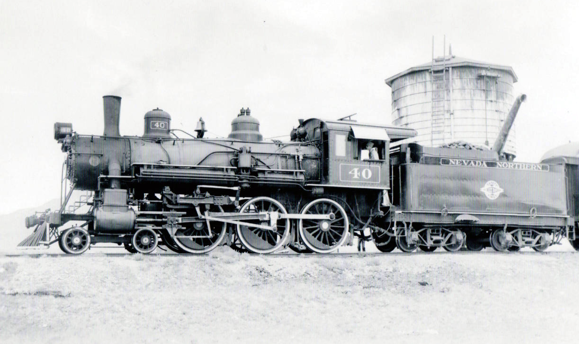
In 1986, Kennecott donated the Ore Line, along with the East Ely yard and shop facilities, to the White Pine Historical Railroad Foundation, which established the Nevada Northern Railway Museum. The museum operates a heritage railroad on the Ely-to-Ruth and Ely-to-McGill segments, using historic steam and diesel locomotives, including the Nevada State Locomotive #40 (a 4-6-0 built in 1910) and #93 (a 2-8-0 built in 1909). The museum’s collection also includes an electric locomotive, diesel-electric locomotives, and historic freight and passenger cars, all dating to the early 20th century.

The East Ely yard, with over 70 buildings and structures, escaped modernization due to its remote location and the decline of the mining industry, making it one of the best-preserved railroad complexes in the United States. In 2006, the East Ely shops complex was designated a National Historic Landmark, recognized for its completeness and authenticity. The Smithsonian Curator Emeritus described it as the “best preserved, historic railroad bar none.”

The museum offers passenger excursion trains, hands-on experiences like the “Be the Engineer” program, and special events such as the Haunted Ghost Train, Polar Express, and Sunset, Stars, and Champagne Trains. In 2021, a $10 million federal grant was announced to extend the heritage line to McGill, with plans to potentially restore the entire mainline for tourism. The disused Cobre-to-Ely line, acquired by the city of Ely in 2006, remains under consideration for future revival.

Legacy

The Nevada Northern Railway played a pivotal role in Nevada’s copper industry, connecting remote mines to national markets and facilitating economic growth in White Pine County. Today, the Nevada Northern Railway Museum preserves this legacy, offering a living history experience that attracts thousands of visitors annually. Its pristine locomotives, original rolling stock, and well-preserved facilities provide a unique glimpse into the steam railroad era, ensuring the railway’s story endures for future generations.

Nevada State Historic Marker 100

Nevada State Historical Markers identify significant places of interest in Nevada’s history. The Nevada State Legislature started the program in 1967 to bring the state’s heritage to the public’s attention with on-site markers. These roadside markers bring attention to the places, people, and events that make up Nevada’s heritage. They are as diverse as the counties they are located within and range from the typical mining boom and bust town to the largest and most accessible petroglyph sites in Northern Nevada Budget cuts to the program caused the program to become dormant in 2009. Many of the markers are lost or damaged.

Most of the markers across the state are large blue metal markers. However, there are a variety of other marker styles out there. For this guide they have been simplified into a few categories (blue, blue small, concrete, and stone). Sometimes, the markers are on buildings, fences, or metal stands.

Mark Requa’s Nevada Consolidated Copper Company laid 150-mile of track from Cobre, on the Southern Pacific line, to Ely in 1905-06 to haul ore from the Copper Flat mines west of Ely.

Ore was loaded into railroad gondolas at Copper Flat for the trip to the smelter at McGill, over a double-track trestle that was 1720 feet long.  The trestle burned in 1922 and was replaced with an earth-fill span.

Passenger service and the “school train” carrying McGill youth to Ely High School ended in 1941.  With the closing of local copper mines in 1983, the railroad ceased operations.  Currently, part of the line serves the Nevada Northern Railway Museum for live steam rides.  The East Ely shop complex for the Railway was listed as a National Historic Landmark District in 2006. 

STATE HISTORICAL MARKER NO.  100

STATE HISTORIC PRESERVATION OFFICE

Nevada State Historic Marker 100 Map

Nevada State Historic Marker 100 Summary

NameNevada Northern Railway
LocationEly, White Pine County, Nevada
Latitude, Longitude39.2526, -114.8781
Nevada State Historic Marker 100

References

Ely Forging The Link – Nevada State Historic Marker

The “Forging the Link” historical marker in Ely, Nevada, encapsulates the story of a town that became a vital hub in the American West due to its strategic location and economic contributions. The marker, part of Nevada’s historical marker program overseen by the State Historic Preservation Office (SHPO), commemorates Ely’s role in connecting the region through mining, transportation, and community development.

Early Exploration and Mapping (1859)

James H. Simpson (1813–1883)

The story of Ely begins with its placement on the map by James H. Simpson during his 1859 exploration of the Great Basin. As a U.S. Army officer, Simpson conducted surveys to identify potential routes for communication and travel across the vast, arid region. His work highlighted Ely’s strategic position, laying the groundwork for its future development as a regional center. This initial mapping was critical, as it introduced Ely to the broader narrative of westward expansion and connectivity in the United States.

Mining Boom and Economic Growth (1860s–1890s)

In the 1860s, the discovery of silver and gold deposits in the nearby Robinson Mining District spurred interest in the area. These discoveries attracted prospectors and settlers, transforming Ely into a burgeoning hub. By 1887, Ely had grown sufficiently to become the county seat of White Pine County, solidifying its administrative importance. The real economic surge came in the early 1890s with the discovery of significant copper deposits. Copper mining became the backbone of Ely’s economy, drawing investment and labor to the region and necessitating infrastructure to support the industry.

The Nevada Northern Railway (1900s)

A pivotal development in Ely’s history was the establishment of the Nevada Northern Railway, headquartered in East Ely. Completed in the early 20th century, this 150-mile railway connected Ely’s mines in Ruth to a smelter in McGill and linked the town to the transcontinental railroad to the north. The railway was instrumental in transporting copper ore and other goods, effectively “forging the link” between Ely and national markets. This connectivity not only boosted Ely’s economy but also positioned it as a critical node in the supply chain of the American West, facilitating trade and communication across vast distances.

Nevada Northern Railway

The Lincoln Highway and Road Networks (1913–1922)

Ely’s role as a transportation hub was further cemented in 1913 when the transcontinental Lincoln Highway, one of America’s first coast-to-coast automobile routes, was routed through the town. Although the road was not paved until 1922, its inclusion of Ely underscored the town’s importance as a stopping point for travelers crossing the Great Basin. By the late 19th century, Ely was already connected by a network of wagon roads, but the Lincoln Highway elevated its status. Additionally, two other major roadways—U.S. Route 6 (designated in 1937, formerly the Midland Trail) and U.S. Route 93—converged at Ely, making it a crossroads for travelers moving between Canada, southern California, and beyond. With over 2,000 residents by the early 20th century, Ely offered essential services, making it an ideal stop for weary travelers.

The Historical Marker’s Creation

The “Forging the Link” marker, erected by the Nevada State Historic Preservation Office, was designed to capture Ely’s multifaceted role in connecting the Great Basin through exploration, mining, and transportation. While the exact date of the marker’s installation is not specified in available records, it is part of a broader initiative to document Nevada’s history through physical markers. The marker’s title, “Forging the Link,” reflects Ely’s historical significance as a connector—geographically, economically, and socially—in a region characterized by its isolation.

The marker likely emerged from a collaborative effort involving local historians, community members, and the SHPO, which oversees Nevada’s historical marker program. Such markers are typically proposed by local groups or agencies, such as the Bureau of Land Management’s Ely District, to highlight significant historical narratives. The content of the marker emphasizes Simpson’s exploration, the mining boom, the Nevada Northern Railway, and the Lincoln Highway, weaving together the threads of Ely’s development into a cohesive story of regional importance.

Significance and Legacy

The “Forging the Link” marker serves as both an educational tool and a point of pride for Ely’s residents. It highlights the town’s resilience and adaptability, from its origins as a mapped point in the Great Basin to its growth into a mining and transportation hub. The marker also underscores Ely’s enduring role as a service center for travelers, a legacy that continues with its position at the intersection of major highways. For visitors, the marker offers a glimpse into the challenges and triumphs of life in the American West, particularly in a region as remote as White Pine County.

Today, the marker stands as a testament to Ely’s historical contributions and its ongoing relevance. It invites reflection on how infrastructure and economic activity can transform a small town into a vital link in a larger network, a theme that resonates with Nevada’s broader history of connectivity and development.

James H. Simpson put the future site of Ely on the map during his 1859 exploration through the Great Basin.  In the 1860s, silver and gold deposits were discovered nearby in what became the Robinson Mining District.  Ely developed as a regional center, becoming the White Pine County seat in 1887.  The area grew dramatically in the early 1890s with major copper discoveries.  The Nevada Northern Railway, headquartered in East Ely, carried ore from the mines in Ruth to the McGill smelter, as well as connecting Ely to the world on its 150 mile route north to the transcontinental railroad.

The towns of eastern Nevada were joined during the late nineteenth century by a network of wagon roads.  In 1913, the road through Ely was incorporated into the transcontinental Lincoln Highway, though it was not paved until 1922.  Ely had over 2,000 residents and offered many services, making it an excellent stopping place on the long road across the Great Basin.  When the copper industry declined after World War I, the struggling town turned to travelers for income.

The Lincoln Highway was designated U.S. 50 in 1926.  By mid-century the popularity of the Victory Highway, now Interstate 80, reduced U.S. 50 to the status of “The Loneliest Road in America.”

In addition to the Lincoln Highway, two other major national roadways converge at Ely.  The Midland trail, designated Route 6 in 1937, was an early coast to coast automobile road that also connected Ely to Tonopah and southern California.  U.S 93, which passes north-south through Ely takes travelers from Canada almost to the Mexican border.

STATE OF NEVADA HISTORIC PRESERVATION OFFICE

AT&T

Land Services, Inc.

MACTEC Engineering and Consulting, Inc.

Ely Renaissance Society

Bureau of Land Management, Ely District

Nevada State Historic Marker 269 Map

Nevada State Historic Marker Summary

NameEly Forging The Link
LocationEly, White Pine County, Nevada
Latitude, Longitude39.2488, -114.8902
Nevada State Historic Marker269