
Big Bear, CA
I quiet mountain community full of back country adventure.
The Journey is the destination


The Tombstone Epitaph is a historic newspaper in the American West, closely tied to the lore of the Wild West and the famous town of Tombstone, Arizona. It was founded on May 1, 1880, by John Clum, a former Indian agent and the first mayor of Tombstone. The newspaper played a significant role in documenting the events of one of the most storied periods in American history.
John Clum founded the Tombstone Epitaph during a time when Tombstone was booming due to the discovery of silver in the nearby mountains. The town quickly grew into one of the largest and most notorious in the West, attracting miners, gamblers, outlaws, and lawmen alike. Clum, a staunch Republican and supporter of law and order, used the paper to promote his views and to support the efforts of the Earps, who were the town’s law enforcement at the time.
The newspaper’s name, “Epitaph,” was reportedly chosen by Clum as a nod to the violent and often deadly nature of life in Tombstone. He believed that the paper would serve as the “epitaph” for many of the stories and lives that would pass through the town. The Epitaph became known for its bold headlines, sensational stories, and fierce editorials.
One of the most famous events covered by the Tombstone Epitaph was the Gunfight at the O.K. Corral on October 26, 1881. The shootout between the Earp brothers—Wyatt, Virgil, and Morgan—and Doc Holliday on one side, and the Clanton and McLaury brothers on the other, was a pivotal moment in Tombstone’s history. The newspaper provided a detailed account of the event, and its coverage helped shape the public’s perception of the Earps as lawmen battling against lawlessness.
As Tombstone’s silver mines began to decline in the late 1880s, the town’s population dwindled, and the Tombstone Epitaph faced financial difficulties. The paper struggled to survive but managed to continue publishing, albeit with less frequency. Over the years, the Epitaph shifted from being a daily to a weekly, and eventually to a monthly publication.
In the 20th century, the Tombstone Epitaph experienced a revival as interest in the Old West and its colorful history grew. The newspaper became a cherished piece of Americana, and its archives were preserved as valuable historical records. In the 1960s, the paper was revived as a historical publication, focusing on the history of Tombstone and the American West. It continues to be published today, both as a historical monthly and as a tourist newspaper, providing visitors with stories and insights into the town’s storied past.
The Tombstone Epitaph remains one of the most iconic newspapers of the American West. Its coverage of the events in Tombstone, particularly during the 1880s, has made it a key source for historians and enthusiasts of the Wild West. The newspaper not only documented the events of a bygone era but also helped shape the legends that continue to captivate people today.
 The Tombstone Epitaph – March 27, 1882Frank Stilwell On March 27, 1882, The newspaper the Tombstone Epitaph announced the murder of Frank Stilwell in Tucson Arizona. Frank Stilwell was an outlaw… |
 The Tombstone Epitaph, March 20, 1882The Tombstone Epitaph, March 20, 1882 reports of the murder of Tombstone Resident Morgan Earp while playing pool in Tombstone, Arizona. This event followed the… |
 The Tombstone Epitaph, October 27, 1881The following is the original transcript of The Tombstone Epitaph published on October 27, 1881 on the infamous gun fight at the O K Corral… |
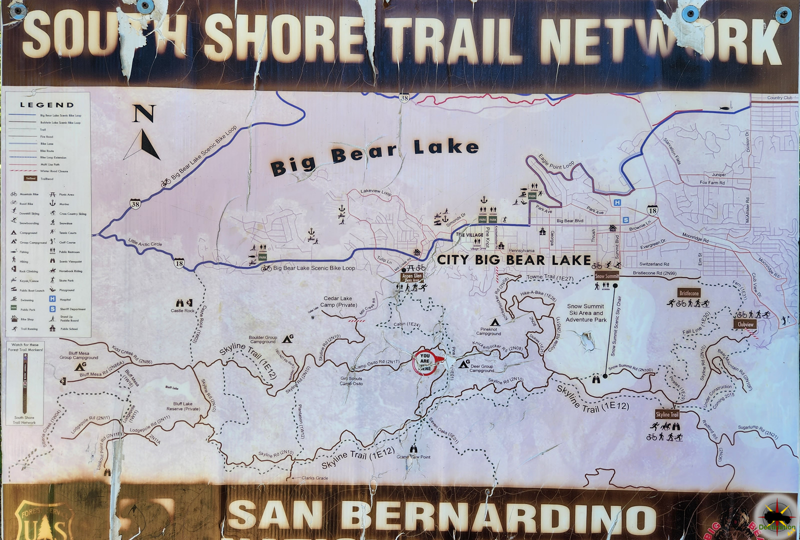
Camp Osito Road is a back country 4×4 trail which connects Knickerbocker Road to Skyline Drive in Big Bear, California. The seldom travelled road is an access route to a local Girl Scout Camp.

Route 2N17 branches from the Knickerbocker trail about two miles from either end and wanders towards the west by Camp Osito. From there, the route continues through the heart of the San Bernardino Mountains until it intersects with Skyline Drive. This is at best an intermediate trail and offers views of Big Bear Lake and the surrounding forests and manzanita groves.
Big Bear Mountains, nestled in the heart of Southern California, offer a breathtaking escape into nature’s splendor. With a majestic backdrop of towering pines and rugged terrain, this mountainous haven beckons outdoor enthusiasts and adventure seekers alike. The towering peaks, including San Gorgonio Mountain, provide year-round recreational opportunities, from exhilarating ski slopes in the winter to invigorating hiking trails during warmer months.
Due to the proximity to Big Bear, it is quite common for this route to be used by hikers, bickers, quad riders and 4x4s alike, so keep an eye out for traffic.
| Name | Camp Osito Road |
| Location | Big Bear, San Bernardino, California |
| Latitude, Longitude | 34.2243, -116.9378 |
| Elevation | 7,500 feet |
| Distance | 1.8 Miles |
| Elevation Gain | 352 feet |
Camp Osito Road is part of the South Shore Trail Network located in the San Bernardino Mountains, near Big Bear, California.
 Camp Osito Road – 2N17Camp Osito Road is a back country 4x4 trail which connects Knickerbocker Road to Skyline Drive in Big Bear, California. The seldom travelled road is… |
 Clarks Grade 1N54Clarks Grade 1N54 Trail Head dropping down into Barton Flats from Skyline Drive. Clarks Grade 1N54 is a steep and scenic descent from the top… |
 Knickerbocker Road – 2N08Knickerbocker Road - 2N08 is a steep and beautiful drive from near the town of Big Bear, California to Skyline Drive. The route is a… |
 Skyline Drive 2N10Skyline Drive 2N10 offers higher elevation views of Big Bear, California Skyline Drive 2N10 is the unofficial name for USFS Road 2N10 that begins just… |
Knickerbocker Road – 2N08 is a steep and beautiful drive from near the town of Big Bear, California to Skyline Drive. The route is a popular destination and common for hikers, bikes and vehicles alike. The route winds up the mountain from the village in Big Bear up to the top of the mountain offering some spectacular vistas and the valley below.

Knickerbocker Road – 2N08 is accessed from Highway 18 in Big Bear, about two blocks east of the village. The trail head is located 3/4 of a mile from the highway off of Knickerbocker Road. The trail begins with a tight left turn and steeply gains alititude. from the valley floor on its journey up to Skyline Drive.

Along the route, you journey deep into a lush pine forest with a few seasonal streams to nourish the lush green plant life. Manzanita Bushes fill the landscape, along with a variety of seasonal wild flowers as you continue to climb to the ridge of the mountain. Don’t forget to admire the views of Big Bear lake as you make the journey.
Once the trail terminates at the Grand View Vista at Skyline drive, there is a very small parking area to relax, picnic and enjoy the alpine view of Barton Flats and valley below. From here, you can return as you came, or pick any of several trails from the South Shore Trail Network including Skyline Drive,
| Name | Knickerbocker Road – 2N08 |
| Location | Big Bear, San Bernardino County, California |
| Latitude, Longitude | 34.2162, -116.9192 |
| Length | 4 Miles |
| Elevation Gain | 890 feet |
Knickenbocker Road is part of the South Shore Trail Network.
Camp Osito Road – 2N17Camp Osito Road is a back country 4x4 trail which connects Knickerbocker Road to Skyline Drive in Big Bear, California. The seldom travelled road is… |
Clarks Grade 1N54Clarks Grade 1N54 Trail Head dropping down into Barton Flats from Skyline Drive. Clarks Grade 1N54 is a steep and scenic descent from the top… |
Knickerbocker Road – 2N08Knickerbocker Road - 2N08 is a steep and beautiful drive from near the town of Big Bear, California to Skyline Drive. The route is a… |
Skyline Drive 2N10Skyline Drive 2N10 offers higher elevation views of Big Bear, California Skyline Drive 2N10 is the unofficial name for USFS Road 2N10 that begins just… |
Chloride Arizona is the oldest continuously inhabited Silver Mining town located in Mohave County, Arizona. The name derives its named from Silver Chloride (AgCl) which is found in abundance in the local Cerbet mountains.

Chloride’s modern history began in the late 19th century when prospectors, drawn by rumors of silver and other valuable minerals, began to explore the nearby hills and canyons. In 1863, a prospector named John Moss struck silver in the area, leading to a flurry of activity as more miners and settlers arrived. The first official post office was established in 1866, and Chloride was officially born.
Chloride experienced rapid growth during the late 1800s as mines produced substantial amounts of silver, lead, zinc, and other valuable minerals. The town’s population swelled. Businesses, saloons, and other establishments sprung up to cater to the needs of the growing community. At its peak, Chloride boasted a theater, several hotels, and a bustling main street.

However, like many mining towns of the era, Chloride’s prosperity was short-lived. Fluctuating metal prices, mine closures, and the depletion of easily accessible minerals led to a decline in the town’s fortunes. By the early 20th century, Chloride entered a period of decline. Much of its population began to dwindle as residents sought opportunities elsewhere.
Despite the challenges, some residents remained in Chloride, and the town managed to maintain a semblance of its former self. The 20th century saw the rise of tourism as visitors were drawn to Chloride’s picturesque desert landscapes, historical buildings, and remnants of its mining heritage. Efforts to preserve the town’s history led to the restoration of several historic structures, including the Monte Cristo Saloon. The saloon proudly claims to be Arizona’s oldest continuously operating bar.
In recent decades, Chloride has experienced a revival fueled by a mix of nostalgia, artistic expression, and a desire to escape the hustle and bustle of city life. The town has attracted a diverse group of residents, including artists, retirees, and those seeking a slower pace of life.
One of Chloride’s most unique and captivating features is the open-air Chloride Murals project. In the early 1960s by local artist Roy Purcell, this project has transformed the town into a vibrant canvas. Murals depicting scenes from Chloride’s history, Native American culture, and the American West decorate the sides of buildings and rock formations.
| Name | Chloride, Arizona |
| Location | Mohave County, Arizona |
| Latitude, Longitude | 35.4047, -114.1812 |
| Elevation | 4,022 ft (1,226 m) |
| GNIS | 2882 |
| Population | 229 |
| Max Population | 2000 |

Warm Springs Canyon Road is a rugged, scenic backcountry route in the Panamint Range of Death Valley National Park, California, offering a challenging off-road adventure through stark desert landscapes, historic mining sites, and access to the tranquil Warm Springs Camp. This unpaved road is not a hiking trail but a 4×4-only route, winding through the heart of the Panamint Mountains from Panamint Valley to Butte Valley. Spanning approximately 17-20 miles one-way with elevations from 1,500 to over 4,000 feet, it features dramatic canyon walls, Joshua tree-dotted flats, and occasional wildlife like bighorn sheep or wild burros. As of August 14, 2025, the road is open following repairs from the August 2023 flash floods caused by Hurricane Hilary, but conditions remain rough with loose gravel, rocky sections, and potential washouts during monsoon season (July-September). Always check the National Park Service (NPS) website or visitor centers for real-time road status, as extreme heat (summer highs often exceed 110°F) and remoteness require meticulous preparation.
The Panamint Range, including Warm Springs Canyon, has a rich history tied to Native American habitation, mining booms, and modern preservation efforts. The Timbisha Shoshone, indigenous to Death Valley, used the region for seasonal hunting and gathering as early as 1000 CE, navigating the canyons for resources like mesquite and water sources like Warm Springs. Their presence persisted despite later Euro-American encroachment.
Mining activity surged in the 1870s during the California Gold Rush’s tail end. The Panamint Range became a hotspot after silver and gold discoveries in nearby Panamint City (1873-1876), though Warm Springs Canyon itself saw more activity in the late 19th and early 20th centuries. By the 1880s, prospectors explored the canyon for gold, silver, and later talc, a soft mineral used in industrial applications. The Butte Valley Mining Company, incorporated in 1889, worked claims in nearby Goler Canyon and Warm Springs, targeting gold and silver veins yielding up to $20 per sack. Talc mining dominated by the 1930s, with operations like the Western Talc Company and Pfizer’s mines employing workers through World War II. Notable figures included Asa “Panamint Russ” Russell, who built the Geologist’s Cabin in Butte Valley in 1930 while prospecting gold, and Louise Grantham, who operated talc claims in the 1930s-1940s.
The early 20th century saw transient mining camps, with Warm Springs serving as a water source and rest stop for prospectors. The road itself evolved from wagon trails used by miners to access claims, later graded for vehicle use in the mid-20th century. By the 1960s, mining declined, and the area’s inclusion in Death Valley National Monument (established 1933, expanded to a national park in 1994) shifted focus to conservation. The Warm Springs Camp pools were constructed in the mid-20th century, possibly by miners or early park stewards, enhancing the site’s appeal for backcountry travelers.
Today, Warm Springs Canyon Road remains a testament to the region’s mining heritage, with relics like rusted machinery and stone cabins preserved under NPS oversight. Its remote beauty and historical significance make it a must-visit for those equipped to handle its challenges, offering a window into Death Valley’s rugged past and pristine present.