Back country ethics

Back country ethics came to the forefront recently. Over the last weekend, my wife and I decided to take a camping trip into the back country of Death Valley National Park.  We were inspired to return to Racetrack Valley, and over night at the Homestake Dry campground.  Upon our return, we were greeted with the grim news that another hiker had died in Zion National Park.  Zion is a personal favorite location and I know it well, and every time someone has an accident in the area I can’t help of think of the small little details that allow these tragedy’s to occur.  I would later recall that an actor died in Death Valley National Park this year.  There is, in fact, a book series written by Michael P. Ghiglieri that emphasizes death in various National Parks and the locations of each, are places which I frequent.

Back country ethics forced me to help a girl not drive this road in a acura.
Looking down at the Lippincott Mine Road from the Lippincott Mine, with Saline Valley in the distance.

To be sure, although stories like these grab attention and headlines I am sure that they are overblown in their publicity and for the most park the National Parks are safe.  The drama in each example is that we all visit there locations and with rare exception we all return with photo graphs and memories to last a life.  Many of this accidents are preventable, with the understanding the hindsight is always clear, I still can’t help but wonder what would happen should I ever find myself in a one of these situation?

Prior to any trip, I check and double checked my gear list.  The list changes depending upon time of year, destination, etc… but known the less I try to anticipate potential issues while I am loading the jeep.  The jeep is always packed with a first add kit, tools, 2 meter ham and CB radio, area maps, cell phone, extra water, fuel and food.  This is standard operating procedure for us.

During our weekend in Racetrack Valley we ran into a total of four other vehicles over the course of 24 hours.  Of these autos, two were in need of some assistance and I was more than happy to provide help.  The first car was a new Jeep Grand Cherokee which appeared to be just off the lot.  The Grand Cherokee is a great car, and they just had a flat tire.  The racetrack playa road claims many tires each year, and the owner was able to get the tire changed in just a few minutes.  The flat tire was a minor issue and they were soon on their way, although there had to be careful because they did not have a true spare tire but rather one of those light weight little donuts tires.

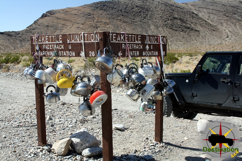
After an overnight stay at the Homestake dry camp, we left for our day full of explorations.  After a brief stop at the Lippincott Mine we headed north towards Teakettle Junction.  Upon arrival, our plan was to head east towards Hunter Mountain, however before we could make the turn the driver of a parked white Infinity coupe flagged us down requesting help.  So, I stopped the jeep, got out and walked towards the Infinity.  Our of the car, a woman in her 20’s or early 30’s stepped out of the car.  She was dressed like she was going to a summer bar-be-queue, complete with perfume, tight shorts, stylish shoes and make up in place.  So, seventeen miles in the back country of Death Valley National park, she pulled out a cheap gas station map and asked for directions.

Lippencott Mine Road from Racetrack Valley, Death Valley National Park, CA

I took a minute for me to completely comprehend what was being asked of me.  So, she starts out, pointing to Teakettle Junction of the map and asks if she was in fact “there”.  I told her “Yes, this is Teakettle Junction” which is funny to me since Teakettle Junction has a huge sign which reads “Teakettle Junction”, which is turn, is covered with about 50 Teakettles.  To which she points in the area of Saline Valley and tells me she is meeting her friends and wanted to know if she should take “this road” and points to the Lippincott Mine Road.  For those how are not aware, the Lippincott Mine Road is a non-maintained steep 4×4 trail with a sheer cliff on one side.  This is not the sort of thing you should try in an Infinity coupe with no low range and street tires and I told her politely that she is foolish for thinking  of it.  She responded, “yeah, my friend told me that.”

TeaKettle Junction lets you know you are starting to get close to the Racetrack.

To summarize now, I ran into someone, clearly not prepared for her environment, who did not listen to the advice of her friend, and is now asking for directions, 17 miles down a wash-boarded road, from a complete stranger.  I suggest that she turn around, head back to the highway, and jump on the pavement and take the long way around.  To which, she asked about “this road” and she points to the “Hunter Mountain Road”.  I told her that I didn’t know about the condition of “that road”, and my guess is that the road was more of the same of what she had already done, but “I hasten to add, I am not sure.”  She thanked me, and just as I left I told her to “turn around”.  I jumped back in the Jeep and went on to my next destination, the Lost Burro Mine.

After some time at Lost Burro, lunch and some further exploration a front arrived in the area and rain began to fall.  We made our may make down to the Hunter Mountain Road.  Prior to ending our trip, I want to run down to some other mines as the rain fell harder.  At which point, I noticed that we were following fresh street tire tracks on the road.  The car in front of us lost traction as it struggle to climb out of a sandy 6 inch gully which would not been an issue for any small SUV, but a different story from an Infinity car.  Each turn we were surprised not to find this woman, stuck by the side of the road with a flat tire or something else.  Mile after mile we followed the tracks until we reached our final destination at the Quakenbush Mine, at this point the turned around and ended our trip.

On the drive home, my lovely wife Heather and I discussed her situation.  We both agree that she was stupid for putty herself in danger.  She did not listen to her friend.  She did not appear prepared for anything, yet alone the back country of Death Valley.  I potentially saved her life that day, but I can’t help but wonder if I should have been more firm or blunt in getting her to turn around.  But then again, would it have mattered?  She already ignored her friends advice.

Where does my obligation to help end? Or does it ever end?  Of coarse, if our paths crossed deep in the Hunter Mountain Road we would completely helped her out and ensure her safety.  However, if you have an dealing with an adult, presumably of sound mind, when is enough help, enough?  She wasn’t in danger sitting at Teakettle Junction.  She is probably made her destination and  is probably safe and sound.  She probably still does not realize the potential danger of her situation that day.  I believe I talked her out of the Lippincott Mine Road “shortcut”, but I don’t know.  Perhaps, a series of small seemingly unimportant events was already cascading to push her towards her destiny which can only be seen with hindsight.  Perhaps, I interrupted the series of unfortunate events and removed a chapter from Mr. Ghiglieri’s next book

Eastern Sierras, Fall 2002

The Merced River flowing through Yosemite Valley.

In late October I managed to get away from the office again, and again headed to the High Sierras. It is not a difficult decision to travel to the stomping grounds of Ansel Adams, Galen Rowell, and John Muir which is located just over 250 miles from my house. My brother and I again, over packed my Jeep, and set off for the Eastern Sierras early on a Saturday morning. Just over 6 hours later, we pulled into our camping site at Silver Lake campground, in the June Lake Loop.

After a very cold nights sleep, we took a short drive up to Mono Lake to a short hike to the Mono Lake Fissures, and a little bird watching. The Mono Lake fissures are found on Black Point and just of short hike over some steep and sandy terrain. No trails to be found, but a fun adventure none the less. My brother the Field Biologist went crazy over the bird populations to be found in the inland dead sea of California. After a week listening to my brother, I must admit that I am starting to develop an appreciation for our feathered friends. Mono Lake is a wonderful place for birding, as it is a major food source, and is the breeding ground for 80 – 90% of the California Gull population depending upon whom you believe.

Monday morning found another cold morning for us. We packed up our gear, and headed for a short drive over the Tioga Pass, and into Yosemite Valley. I had visited the valley the previous year, and vowed to return quickly. My first afternoon in the valley was spent exploring the Merced River, and composing reflections of Half Dome.

After a noisy nights sleep, we began our days activities. On the short list we wanted to visit the Mariposa Grove, and Glacier Point. The Mariposa Grove is a ‘small’ grove of Giant California Redwood trees. Small is a relative term, when you are describing the largest living things on the planet, but I personally was expecting huge numbers of these large trees. The scale of these trees is just amazing, and to compare them to any other thing, does not do them justice. After a quick 4 miles hike among the Giants, we drove to Glacier Point for the late afternoon light.

Glacier Point could quite frankly summarize the image of Yosemite. On on high granite pedestal, Glacier Point projects into the middle of the valley, and from a single location, one can see Yosemite Falls, Vernal Falls, Nevada Falls, North Dome, and of coarse the ever noble Half Dome. I knew what to expect when we pulled into the parking lot and took the short hike to the point, but to describe this place with words would be pointless for me. I choose to narrative this place 1000 words at a time. As the sun dropped, along with the temperature, the light on the Half Dome, yellowed and warmed the timeless granite. Just after sun down, the view of Hale Dome took a magnificent metamorphosis. The sun light shown turn the length of Yosemite Valley, through the narrow valley door and shown a wonderful pink alpen glow against the pastel blue sky!

The next day, we took a bit of a hiatus, and just wondered around the valley floor. A quick stop at the Visitor Center, and store accompanied a walk down the Merced River towards Mirror Lake.

Our time in the Yosemite Valley was unfortunately over, we headed back over Tioga Pass, and met up with a friend on Convict Lake just South of Mammoth Mountain. A small lake nestled in the glacier carved val lies of the sierra, Convict lake is a prime location for fishing, and my brother quickly caught three trout just feet from our campsite. We headed towards Mammoth to pick up much needed supplies.

We we started the next day, our newly enlarged party headed towards the Minaret Wilderness, Devil’s Postpile National Monument, and the San Joaquin river valley. On our daily hike, we jumped into the Ansel Adams Wilderness and dropped over to Rainbow Falls.

On our final full day, we again drove to Mono Lake as part of our show and tell to my friend. We spent the afternoon soaking in the Hot Springs just south of Mammoth.

** I took over 7 rolls of film on this trip. Unfortunately, during development the lab destroyed all of the images that I worked so hard to capture. I have only memories of this wonderful trip, and my galleries will not grow. **

Antelope Valley Poppy Reserve, Spring 2003

After a surprise day off, I another chance to visit the western end of Antelope Valley to play around with my camera at the Antelope Valley Poppy Reserve. I was not as excited this time around as the flower bloom was intense, but not nearly as spectacular just a few days before. But, a day out is a day out, and I was going to enjoy it. Nature was against us on this day, we had beautiful light, nice cloud layer to diffuse some light, and a 25 mph breeze that would just not let up all day.

A Davey Gilia stalk poking up between the California Poppies in the Antelope Valley Poppy Reserve.

My goal this spring was to get a nice flower shot that I would desire to blow up as a photograph, however, these conditions were not condusive towards this task and a true exercise in patience. It looks likely that I will not reach this goal this season, the flowers bloom has begun to wane, and my only hope appears to be in the foothills of the eastern sierras in a few weeks.

Continue Reading →

Red Rock Canyon, CA Winter 2004

In the winter of 2004, I decided to purchase a 4×5 camera. The reasons are too many to go into in this report. So, in February my brother and I jumped into my Jeep and drove North towards Red Rock Canyon about 2 hours away. It was a beautiful day, and we almost made it all the way to Red Rock Canyon before my Jeep turned up a little 4×4 trail leading up to an old mining district.

The hike in this area was amazing. A short hike from the car, and it seemed we traveled years back in time as we hiked up the narrow valley towards the mine opening. We scouted the area before I hiked back down to the mine opening that grabbed my attention. The dark sun dried wood held back the collapse of the purple and yellow rock piled high above.

This simple black and white polaroid was my first large format taken in the wilderness. I was amazed when I opened up the lens and peered through the ground glass for the first time. My imagination soared when I realized I was using equipment very similar to the great photographer of the past. Looking at an abandon mine through the glass of a camera that will be abandoned by technology seemed poetic. It took my 15 minutes to compose, re meter, compose, double-check and finally press the cable release to capture this image, but the time flew by in my world. The camera and subject matter may be a scene from the past, but I think that this image represents my future.

Utah Trip Report, Fall 2003

Hole in the wall trail in Escalante, Utah

This year’s trip was very unique, and will be hard to document in way that is interesting Utah trip. My immediate reaction is to throw up a ton of images and just write “look where I went”.

This years adventure started during the California Wildfires. Friends and family homes located in the San Bernardino Mountains were danger as we left and not all the news we had was good. My brother and I piled into his Four Runner under the smoke filled dawn and made the eight-hour drive to Zion National Park in Utah.

Since we had just over a days wait for our companions for the trip. My brother and I did several hikes out and around the main canyon in Zion while we waited for my photography partner and good friend John Farkas and his wife Abby to arrive.

A quick hike up to the Emerald Pools left us with a great view, but view great photographic opportunities. The quick moving white clouds above gave us great-diffused light, but this light would quickly vanish and made composing and hit and miss venture. That evening, we dropped in on Michael Fatali, and were fortunate enough to get a tour of his dark room and a little map review as well. Thanks Michael!

After losing a day to travel, we awoke near Dance Hall Rock in the Escalante Wilderness. After a morning breakfast we loaded up our backpacks and head out across the sand trail towards “Crack in the Wall”. “Crack in the Wall” is a “Class 2” rock scamper. Since we didn’t know that this really was, we didn’t worry too much as we hiked closer towards the canyon wall. We hiked over prehistoric petrified dunes, dried water pools, and cow trails as we edged ever closer towards the infamous “Crack in the Wall”.

Camping at Dance Hall Rock, Hole in the Rock trail

“Crack in the Wall” is perhaps the most descriptive named structure that I have run across to date. A narrow crack in the towering canyon walls was formed by a large section of stone cleaving away from wall. Perhaps one of the more interesting hiking trails I have seen, we removed our heavy frame backpacks, broke out our rope, and quickly lowered the packs past the narrowest section of the trail. Another twenty minutes of hiking found us near the Escalante River. Light danced on the canyon walls, and reflections glowed in the shallow creek as we explored the canyons looking for the light.

Hiking towards crack in the wall.

After a three-hour hike out of the canyons of the Escalante River, we planned our next days excursion. The decided to head east down the John Burr trail and towards Capital Reef National Park. The Burr Trail is a nice paved windy road that is perhaps one of the most scenic roads I have traveled. We stopped many times on our travels this find day, as the diffused light was booming. Water carved towers of rock illuminated by the soft Utah sun passed by as we drove deeper and deeper into Capital Reef.

Another day of driving took us back towards Los Angeles. We were sad to see our expedition coming to a close, but time was against us. However, we still found time to visit a slot canyon just a few miles away from our route. We certainly could not pass this opportunity

Round Valley Draw slot canyon opens up in a streambed after a very short hike from the trailhead. We walked down the side of the canyon to survey the canyon before lowering ourselves deep into the heart of the Earth. I have stated it previously, but walking a slot canyon is a magical experience. Time, Water, and Sand carve these beautiful canyons for us to visit, and you just cannot appreciate this place until you have been there.

Another wonderful Utah trip.