Western Fence Lizard (Sceloporus occidentalis )
The Western Fence Lizard ( Sceloporus occidentalis ) is perhaps one of the most common lizards in the desert southwest and is also known as a “Blue belly”. Perhaps this commonality is the reason for its name. The Western Fence lizard is found in a variety of habitats and common at elevations up to 10,800 feet. They can be located in forests, desert sage, farmlands and grasslands. This species is typically not found in harsh desert climates and moist forests.
This animal is typically between 2 inches and 3.5 inches in length. They are typically black to brown in colors with stripes on their backs. They have blue colored patches on their ventral abdomen. This reptiles will lay clutches of eggs between 3 and 17 eggs in the spring between April and July. The eggs will hatch within two months of feralization.
This animal are known to eat insects including ant, beetles, flies, spiders and some caterpillars. They typically can be found sunning themselves on rocks, fences and paths. The are a prey item for other animals including larger lizards, birds and also some a mammals. As is common with most reptiles, the lizard is known to hibernate in cooler winter months.
Resources
Rochester Nevada – Pershing County Ghost Town

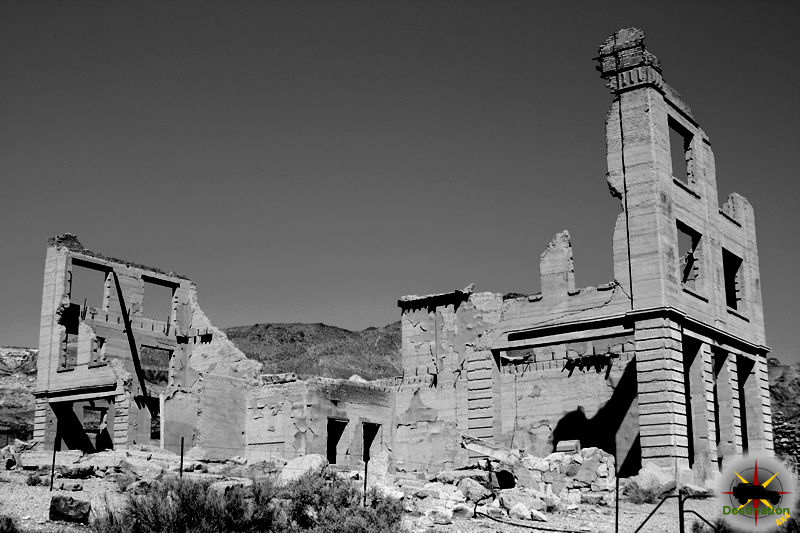
In the 1860s, immigrants and prospectors from Rochester New York discovered gold in the nearby mounts and the silver mining town of Rochester, Nevada was founded. Located in Pershing County, Nevada, Rochester was organize in three districts areas spread across on area of three miles within the canyon. The original mine camp located at the upper end of the valley became known as Rochester Heights and later Upper Rochester or “Old Town”.
Early explorations were small and gold ore was processed offsite. Such was Rochester, until on 1912 Joseph Nenzel discovered a rich silver ore. This event changed the forecast for the insignificant town. The steep canyon walls of surrounding Upper Rochester did not allow for larger populations, so Lower Rochester was created further down the canyon.
The boom town populations swelled with miners and businesses. The upper town commercial district support the saloons and hotels, while the mills and mining operations were hosted in the lower town. At one point, the town had The Rochester Philharmonic Orchestra.

The Nevada Short Line Railway extended a track to Oreana, a town east of Rochester in 1914. From Oreana, a rail was built to Lower Rochester through Limerick Canyon. The rail was extended to the upper camp in 1915 to haul ore to the lower town. Although the track was laid down, the rail never really serviced the mines very well. Accidents, fires and mismanagement caused the service to be unreliable. The mines eventually build a tram between the two towns, however the tram service and railway both failed. The rails were removed in 1920.

Despite theses problems the mining operations continued, however the interest in the location began to subside in 1922. The mines produce over $9 million in gold and silver.
The town of Upper Rochester is currently buried below the tailings of a modern mining operation. Fire destroy much of the lower town in 2012.
Continue Reading →Mazuma Nevada – Pershing County Ghost Town

Mazuma Nevada started its short life in 1907 when the Seven Troughs gold strike started attracting an influx of miners from other areas. The town was named from the Mazuma Hills claims and the camp grew quickly in the mouth of Seven Troughs Canyon.
The summer of 1908 say the camp as the largest in the area with the founding of a post office, bank, three story hotel, fire department and the Seven Troughs District News.
The Darby Mill was built and started production in 1909. The future was relatively bright for this upstart little town.
Yesterday afternoon, at about five o’clock, the town of Mazuma (northeast of Reno) was devastated, eight people were drowned and nine more injured, many fatally, and a property loss estimated at nearly $200,000 by a cloud burst that swept down, unheralded, upon the mountain town. The known dead are:
Edna Russell, Postmistress at Mazuma;
Three children of Wm. Kehoe, all aged under seven;
M.C. Whalen, a miner, aged 35;
Mrs. Floyd Foncannon, drowned in Burnt Canyon six miles north of Seven Troughs canyon.
Those injured so far as can be learned at time of going to press are:
John Trenchard, merchant, probably fatally;
Mrs. Trenchard, badly cut and bruised, may recover.
Mrs. Kehoe, cut about head and face, bruised about body, may die;
Mrs. O’Hanlan, badly injured, may recover.
——————
Today the first witnesses of the flood conductions and who talked to the survivors returned to town. Among them was Drs. Russell and West, H.J. Murriah, J.T. Goodlin, H.S. Riddle, Jack and Will Borland and W.H. Copper.
Lovelock Review-Miner July 12, 1912

The town of Mazuma was build in the flood channel of Seven Troughs Canyon. A nearby cloud burst caused a wall of water estimated between eight and ten feet tall scouring the canyon floor as it raced by.
The Darby Mill survived the flood only to be lost to fire two weeks later. After the flood and fire, the mill was rebuilt operations continued until 1918.
Mazuma Trail Map
Further Reading
Seven Troughs Nevada – Pershing County Ghost Town

In 1894, Frank Ward a sheepman in the area, built seven water troughs to water his sheep. The name Seven Troughs came from this simple event. Seven Troughs is a ghost town and old mining camp in Pershing County, Nevada.
In the fall of 1905, gold was discovered in the upper parts of Seven Troughs Canyon area. This discovery led to the ability to raise capital investment and soon funding was in place for the young mining district. Discoveries were reported in excess of $100,000 per ton in 1907 attracted in miners from Tonopah and Goldfield.
In 1907 a townsite was plotted out and the tent city soon followed. Townsite plots sere sold for $500 a lot, and the small town supported 350 citizens. A water system and school was built to support the population in 1908. The previous year, 1907, saw the construction of the post office, stores and saloons to keep the population happy and give one an insight into the priorities.
At its height their was consideration to bring in rail with the Southern Pacific line from Lovelock, to near by Vernon and up to Seven Troughs. The rail never developed and the mine camp continued to the production of the Kindergarten mine until 1918 and World War I. The Kindergarten mining operations produced about two million dollars from 1908 until its end in 1918.
The post office followed the miners out of the area, and only lease operations continued past this time.
Seven Troughs Trail Map
Resources
Oatman Arizona – Mohave County Ghost Town
Perched precariously on the steep flanks of the Black Mountains in Mohave County, Arizona, at an elevation of 2,710 feet (830 meters), Oatman stands as a defiant relic of the American Southwest’s gold rush era—a “living ghost town” where the ghosts are not spectral but very much alive in the form of wild burros that roam its dusty streets. Straddling the historic alignment of U.S. Route 66 between Kingman, Arizona, and Needles, California—some 25 miles southwest of Bullhead City—this unincorporated census-designated place (CDP) evokes the raw, unyielding spirit of the frontier. Once a booming mining camp that yielded fortunes in gold, Oatman’s narrative is woven with threads of tragedy, triumph, and tenacity: from the harrowing tale of its namesake, Olive Oatman, to the frenzied strikes that swelled its population to over 3,500, and its improbable resurrection as a tourist haven sustained by Hollywood glamour, highway nostalgia, and a herd of free-spirited donkeys. This report traces Oatman’s evolution from a shadowed massacre site to a pinnacle of desert prosperity, its wartime eclipse, and its vibrant persistence as a quirky Route 66 icon in the 21st century.

Shadows of the Past: The Oatman Massacre and Early Exploration (1850s–1890s)
Oatman’s origins are etched in blood and endurance, predating its gold-fueled fame by decades. The town’s name honors Olive Ann Oatman (1837–1903), a 13-year-old Illinois girl whose family’s westward odyssey ended in horror on February 18, 1851, along the banks of the Gila River, approximately 100 miles east of present-day Yuma, Arizona. Traveling as part of the Brewsterite wagon train—a splinter Mormon group seeking a utopian haven at the Colorado-Gila confluence— the Oatmans and their companions faced the perils of the Southern Emigration Route: scorching deserts, scarce water, and marauding bands of Tonto Apache or Yavapai warriors. In what became known as the Oatman Massacre, attackers killed Olive’s parents and seven siblings, leaving only Olive, her sister Mary Ann (aged 7–10), and possibly her brother Lorenzo (who escaped and later reunited with survivors) alive. The sisters were enslaved for a year before Mary Ann perished from starvation and exposure; Olive was traded to the Mohave tribe, who adopted her, tattooed her chin in tribal custom, and treated her as kin for four years. Rescued in 1856 near Fort Yuma through the intervention of a Mojave-Mexican interpreter, Olive’s saga—captivity, cultural assimilation, and redemption—captivated the nation via her 1857 memoir Captivity of the Oatman Girls, fueling frontier fascination with Indian captivity narratives.
The massacre site’s proximity to future Oatman sowed seeds of legend: local lore claims Olive and Mary were hidden at “Ollie Oatman Spring,” a half-mile from the townsite, though historical evidence points farther south. By the 1860s, prospectors like John Moss staked early claims in the Black Mountains, naming one the “Oatman Mine” in her honor—or, per some accounts, after a local miner named John Oatman, Olive’s purported half-Mohave son. Sporadic gold finds yielded modest returns, hampered by the rugged terrain—jagged volcanic ridges, creosote-dotted basins, and temperatures swinging from 110°F (43°C) summers to freezing winters. A narrow-gauge railroad chugged 17 miles from the Colorado River near Needles, California, between 1903 and 1905, but the camp remained a whisper in the desert wind.

Boomtown Fever: Gold Strikes and Frontier Frenzy (1900s–1930s)
The 20th century ignited Oatman’s transformation from tentative outpost to roaring boomtown. In 1902, the Durlin Hotel (later the Oatman Hotel) rose as the county’s oldest two-story adobe, its thick walls shielding miners from dust storms and desperadoes alike. Renamed Vivian in 1906 for a miner’s daughter, the post office formalized the settlement; by 1908, it was Oatman proper, with banks, a chamber of commerce, and saloons slinging whiskey amid the clang of picks and the groan of ore wagons. The 1910 opening of the Tom Reed (or Bluebird) Mine unleashed a torrent: over 24 years, it disgorged $13 million in gold (about $450 million today). But 1915 marked the deluge—a United Eastern Mining Company strike unearthed $10–14 million in high-grade ore, sparking one of the desert’s final gold rushes and swelling the population to 3,500–10,000 souls by the 1920s. The United Eastern alone produced $15 million from 1913–1926, making Oatman and nearby Goldroad Arizona’s top gold producers, rivaling the Comstock Lode’s glory.
Main Street pulsed with polyglot energy: Cornish “Cousin Jacks” (expert hard-rock miners), Mexican laborers, Chinese merchants, and ex-soldiers seeking dry-air cures for World War I gas injuries flooded in, erecting frame shacks, a newspaper (Oatman Miner), assay offices, and brothels. Pack burros—sturdy descendants of Spanish explorers—hauled ore up treacherous switchbacks, their brays mingling with saloon pianos and the distant rumble of stamp mills. Yet peril shadowed prosperity: a 1921 inferno razed much of the town, sparing only the Oatman Hotel, whose bar became a respite for dust-caked claim-jumpers. Hollywood arrived too: Oatman doubled as frontier backlots for films like How the West Was Won (1962) and Foxfire (1955), its crags and canyons lending authenticity. In 1939, stars Clark Gable and Carole Lombard honeymooned in the hotel’s upstairs suite after a Kingman wedding, their romance immortalized in faded photos and lingering whispers of spectral sightings—Oatman’s resident ghost, “Oatie,” is said to haunt the halls.
Eclipse and Endurance: Decline and Route 66 Revival (1940s–1970s)
Oatman’s zenith proved ephemeral. The United Eastern shuttered in 1924 amid fluctuating gold prices and exhausted veins; by 1941, World War II’s metal demands prompted federal orders to halt remaining operations, idling the district’s $40 million legacy (equivalent to $734 million today). Miners departed, leaving burros to fend for themselves in the hills—legally protected by federal law, their descendants now number around 1,900 across the Black Mountains, managed by the Bureau of Land Management (BLM). Population plummeted from 500 in 1940 to near-zero by the 1960s, as Interstate 40 bypassed the town in 1953, rerouting traffic from its wooden sidewalks.
Salvation came via Route 66 nostalgia. The “Mother Road,” paved through Oatman in the 1920s, drew wanderers seeking the old highway’s romance. By the 1970s, entrepreneurs leaned into the Wild West aesthetic: gunfight reenactments by groups like the Oatman Ghost Rider Gunfighters (Arizona’s oldest) and the Bitter Creek Outlaws halted traffic twice daily at 1:30 and 3:30 p.m., cowboys in chaps trading blanks and barbs. Burros, emboldened by tourist carrots (now limited due to health concerns), became unofficial mascots, nosing into shops and vehicles with endearing audacity. The annual Burro Biscuit Toss—flinging gold-painted droppings for prizes—cemented their quirky sovereignty.

Current Status (As of November 2025)
In 2025, Oatman endures as a resilient enclave of 84 residents—a 95% surge from 2020’s census tally of 43, though declining annually by 3.45%—clinging to its Route 66 lifeline amid the BLM’s vast desert expanse. No longer a mining hub (the Gold Road Mine, reopened in 1995, briefly toured visitors before resuming extraction amid high gold prices but remains sporadically active), Oatman thrives on tourism, luring over 500,000 annual pilgrims to its sun-bleached facades and burro brigade. Main Street, a narrow ribbon of weathered wood and adobe, hosts a dozen souvenir shops hawking T-shirts, mining relics, donkey puppets, and Southwestern art; the Oatman Hotel’s ground-floor bar and restaurant serve burgers and “burro ears” (potato chips), while upstairs, the Gable-Lombard suite anchors a museum of faded finery.
The burros—tame enough to peer into car windows yet wild by decree—steal the spotlight, their herds swelling midday as gunshots echo, drawing crowds that pause traffic for theatrical justice. Recent X posts from November 2025 buzz with delight: visitors gush over “cutest baby donkey” videos, warn of nighttime burro hazards on the winding approach from Kingman (a nerve-wracking 23-mile switchback jaunt), and share aurora sightings over the Black Mountains during a rare G4 geomagnetic storm. Yelp reviews (241 as of July 2025) hail its “too tough to die” vibe, with 4.5-star averages praising friendly locals who name the burros and recount mining yarns. Events like the Burro Biscuit Toss persist, though summer heat tempers schedules; no formal services exist beyond basic amenities, and visitors are urged to pack water, respect burro boundaries (no mounting!), and navigate the hairpin roads cautiously.
Oatman remains a microcosm of resilience: a place where gold’s gleam has faded into burro brays and gunshot echoes, yet the desert’s unyielding embrace ensures its stories endure. For real-time road conditions or events, check Arizona DOT or Visit Arizona resources.


