Chief Tecopa – Peacemaker of the Paiutes is Nevada State Historic Marker number 171 and located in Nye County, Nevada. The monument is located at his graveside in Chef Tecopa Cemetery in Pahrump, Nye County, Nevada. Tecopa (c. 1815–1904) was a Native American leased of the Southern Nevada tribe of the Paiute of the Ash Meadows and Pahrump areas.
Tecopa, who’s name means wildcat, along with several other warriors joined Kit Carson and John C. Fremont in the battle of Resting Springs which lasted for three days.
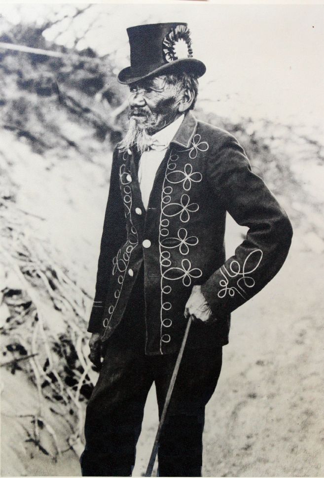
Tecopa maintained peaceful relations with the white settlers to the region and was known as a peacemaker. He often wore a bright red band suit with gold braid and a silk top hat. These clothes are replaced by local white miners when the clothes wore out. This gesture is in gratitude for Tecopa’s help in maintaining peaceful relations with the Paiute.
Tecopa is buried with his son and grandson at the Chief Tecopa Cemetery in the Pahrump Valley, Nevada.
Nevada State Historic Marker Text
Chief Tecopa – Peacemaker of the Paiutes
Chief Tecopa was a young man when the first European Americans came to Southern Nevada. As a leader among the Southern Paiutes, he fought with vigor to save their land and maintain a traditional way of life. He soon realized if his people were to survive and prosper, he would have to establish peace and live in harmony with the foreigners.
During his life, which spanned almost the entire nineteenth century, his time and energy were devoted to the betterment of his people until his death here in Pahrump Valley.
Chief Tecopa is honored for the peaceful relations he maintained between the Southern Paiutes and the settlers who came to live among them.
STATE HISTORICAL MARKER NO. 171
STATE HISTORIC PRESERVATION OFFICE
CALIFORNIA & NEVADA DEVELOPMENTORGANIZATION
Nevada State Historic Marker Summary
| Name | Chief Tecopa – Peacemaker of the Paiutes |
| Location | Pahrump, Nye County, Nevada |
| Nevada State Historic Marker | 171 |
| Latitude, Longitude | 36.2091, -115.9895 |