Badwater Basin

Located at 282 feet below sea level, Badwater Basin is a popular stop for sightseers visiting Death Valley National Park, California. The site is located about 17 miles south of Furnace Creek on Badwater Road.

Badwater Basin located at 282 feet below sea level in Death Valley National Park. - Photo by James L Rathbun
Badwater Basin located at 282 feet below sea level in Death Valley National Park. – Photo by James L Rathbun

History

It is rumored the name Badwater is earned when a mule from a survey team refused to drink from the shallow pool. Despite the name, the only thing “wrong” with the water is its salinity. Oddly enough, if one were to drink it, they would probably just get thirstier. Which is not a good thing in the hottest place on Earth.

Badwater is simply to lowest place in the basin and surrounded by 200 square miles of salt flat. The salt accumulated over time as water flowed into Lake Manly. Lake Manyly is a temporary lake, which forms from run off during thunderstorms and rain showers. As the water from this lake recede, and with no outlet from the basin, the salts and other minerals accumulated. The salt flat is composed on sodium chloride, calcite, gypsum and borax.

Every trip to Badwater in the past few years results in parking frustration and relatively larger groups of people. Take care of yourself in the hotter months as the severe heat can be deadly.

Pets are not allowed on any trail in Death Valley National Park, even if carried. Do not leave your animal in your vehicle. Speak with a ranger about one of the incredible dirt roads where you may walk your pet.

Badwater 135

Badwater is host to the starting line for the Badwater 135, an ultra-marathon for the ultra-crazy. The marathon starts at Badwater and runners, run, jog, and walk over one hundred and thirty miles to the Mount Whitney Portal Campground. Over the course of about two days, the runners gain over 14,600 feet in total elevation and this is done in the heat of midsummer just to make it interesting.

Summary

NameBadwater Basin
LocationDeath Valley National Park, California
Latitude, Longitude36.250278, -116.825833
Elevation-282 feet
OtherRound Trip Length: 1 mile (1.6km) to edge of salt flat
Round Trip Time: 40 minutes
Dificulty: Easy 
Elevation Gain: Flat
Trail Type: Boardwalk then route, out and back 
Location: Badwater Road, 30 minutes (17 miles/27km) south of Furnace Creek
Parking: Paved parking lot with large spaces for RVs and buses
Closest Restroom: Vault toilet located in parking lot
Route: An ADA accessible ramp leads down to a wooden boardwalk. The walking surface is firm and wide beyond the boardwalk. 

Badwater Basin Map

References

Ubehebe Crater

Ubehebe Crater is a volcanic crater located near Grapevine Canyon in Death Valley National Park in California. The crater is approximately 600 deep and one half mile across and a popular spot for visitors in the park. The crater is created by a Maar Volcano, which is a shallow volcano caused when groundwater comes in contact with volcanic magma.

Ubehebe Crater, Death Valley National Park, California

The crater was originally known as “Tem-pin-tta- Wo’sah” from the Timbisha Shoshone Indian phrase for Coyote’s Basket. At some point, the crater was renamed to “Ubehebe” which is the name of a near by mountain and comes from the Paiute Indian name for “Big Basket”. Regardless of the name, the crater does remind one of a basket in the earth.

A Panorama looking from Ubehebe Crater overlooking the cinder fields, Death Valley National Park

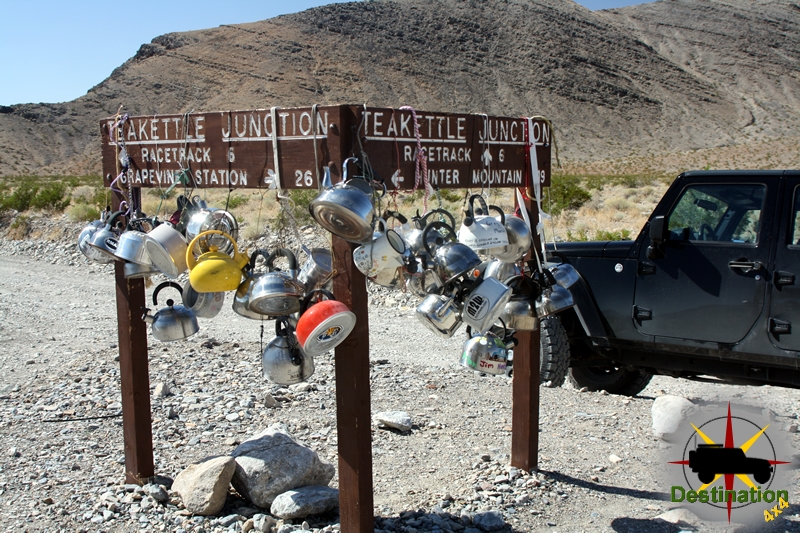
The road into Ubehebe serves as the starting points to the Race Track Valley Road, Teakettle Junction and Hunter Mountain Road.

Hiking

There are a few separate hiking opportunities while exploring the crater.

The crater rim trail, which is about 1.5 miles long, circumnavigates the crater and allows access to Little Hebe crater. The trail has some slight elevation gain, however could be more difficult to hikes with balance issue due to the unstable soil.

There is also a trail down the the bottom of the crater. This is a short trail and very easy going down. The difficulty is hiking back up the 600 feet elevation lost on the way down, in loose volcanic soil.

Ubehebe Crater Trail Map

References

Lower Antelope Canyon

Lower Antelope Canyon one of two slot canyons located off the highway 98 just outside of Page, Arizona near the Utah border.

Entering Lower Antelope Canyon

Slot Canyons are formed in usually arid regions, where a little bit of rain falls, and fulls the dry rivers of the desert southwest.  The water can flash flood, which picks up speed and debris and scours the landscape.  Overtime, the water forces itself into cracks in the rock and widens the deepens the crack into a deep narrow canyon.   Lower Antelope is a commonly overlooked when compared the Upper Antelope Canyon, although does seem to be gaining in popularity.

Hasdestwazi, or “spiral rock arches ” as it is known to the LeChee Chapter of the Navajo Nation, Lower Antelope slowly exposes itself to you as a small crack in the rock which grows slightly in width, and dramatically  in depth as you climb down into the slot canyon.

Unlike Upper Antelope Canyon which is an easy walk, Lower Antelope Canyon is a steep and deep trail as the passage plunges deeper into the rock.  The Navajo Nation is kind enough to maintain metal stairs to aid the trek, however on my last visit the stars where covered in mud, silt and debris from a recent storm which further sculpts the rock.   Upper Antelope pulls you eyes up into the colorful light above, however there is no real sense of depth.  Lower Antelope Canyon constantly reminds you how deep you really are beneath the surface.

The stairs inside of lower Antelope Canyon show signs of a recent flood.

Just like Upper Antelope Canyon, a narrow opening at the top of the canyon only allows a little light the enter the canyon.  This light bounces off the canyon walls, and throughout the day, a light show of glowing rock, shadows and textured water sculpted rock offer a wonderful visuals to the visitors.

The sculpted rock and light offer beauty, texture and scenic photographic opportunities, however this beauty hides a danger.  An August 12, 1997 a group of eleven tourists where killed inside the canyon when a flash flood filled the canyon in seconds.  A sole tour guide survived the tragedy.

As I follow the canyon down towards Lake Powell in the distance, I would constantly find my self touching the smooth canyon rock walls, all the while knowing that a summer monsoon miles aware could end my time on this planet.  However, although always a bit uneasy, it is an amazing place and well worth the trip and the remote risk.

Valley of the Gods

Valley of the Gods is a beautiful sandstone valley and located in the South East corner of Utah near Mexican Hat. alley of the Gods is the lesser known northern extension of Monument Valley and is frequently confused with Monument Valley. The valley is carved out from a layer of eroded sandstone, and features two large table top mesa with are long and narrow in shape. These mesas appear like ship sails again a sea of clear blue skies.  

The seventeen mile trail loops north from highway 163 and then travels back the the south west to connect to highway 261 and recommended for high clearance vehicles.

Valley of the Gods, Utah
Large format photograph take in Valley of the Gods, Utah provided by James L Rathbun

Down towards to the of the valley, two beautiful spires reminded me of sailing ships in the desert. The road winds between them to provide for an amazing drive.

Unlike Monument Valley which is controlled by the Navajo Nation, the valley is managed by the Bureau of Land Management and does not contain any services or campgrounds, or tribal restrictions. There are several small camping spots on the loop and when I visited in October the number of people seems to be quite low.

Valley of the Gods trail map

Warm Springs Road

A short side trip from the Saline Valley Road to the Saline Valley Warm Springs in Death Valley National Park, California. The road is used to access the Warm Springs Hot Springs of the Saline Valley. The region and its hot springs became very popular in the 1960’s

Looking down at the Lippencott Mine Road from the Lippencott Mine, with Warm Springs Road, Saline Valley in the distance.
Looking down at the Lippencott Mine Road from the Lippencott Mine, with Saline Valley in the distance.

The hot springs were improved before the National Park was formed in 1994. As such; showers, bathtubs concrete pools and three bathrooms. these bathrooms are replaced by the Park Service. Palm trees were planted to create am oasis. Additionally, there is a small airport known as the “Chicken Strip”, which is a 1400 foot dirt runway cleared near the hot springs. The “Chicken Strip” landing strip is about a 10 minute walk from the oasis.

There are three distinct springs and camping locations. The warm springs oasis existed as its own four some 40 years prior to the national park service taking over. The location became quite popular and nudity was common. There was quite a bit of controversy when the national park service took over due to the decades long existence of the improvements conflicting with the governments tendency to (over)regulate.

NPS Photo - Mature, non-native palm trees, such as these near the Volcano Pool, will stay in place until they die of natural causes.
NPS Photo – Mature, non-native palm trees, such as these near the Volcano Pool, will stay in place until they die of natural causes.

A “clothing optional” policy is still permitted at the springs, but nudity is frowned upon elsewhere at the site.

The road is maintained for the most part and should be accessible to most 2WD vehicles.

Notoriety

It is said that Charles Manson visited the Warm Springs looking for entrance to the bottomless pit. Manson believed the bottomless pit was an entrance to an underground world, which would protect him from the race war he tried to start as part of his plan to start “Helter Skelter.”

Trail Summary

NameWarm Springs Road
LocationSaline Valley, Death Valley National Park, California
Length7.5 Miles
DifficultyEasy

Warm Springs Road Trail Map

References