Zabriskie Point

Zabriskie Point is perhaps one of the best known and popular overlooks in the entire Death Valley National Park, California. The landmark is named for Christian Brevoort Zabriskie who was the Vice President of the Pacific Coast Borax Company.

Zabriskie Point bathed in warm afternoon light in Death Valley National Park - Photo by James L Rathbun
Zabriskie Point bathed in warm afternoon light in Death Valley National Park – Photo by James L Rathbun

The elevated overlook of a huge area of yellow-brown-black ancient mud lands composed of sediments from the ancient Furnace Creek Lake. A short hike from the parking lot allows is a visitor to see the expanse of the badlands. A longer hike will take the explorer down through Golden Canyon to the floor of Death National National Park. The site is best visited during the “golden hours” of warm light in the evening and mornings. The best viewing occurs at sunrise.

Zabriskie Point - Photo by James L Rathbun
Zabriskie Point – Photo by James L Rathbun

The site was made famous in popular culture by a movie from 1970 of the same name. For those of us who grew up in the 1980s, the cover of the U2 Album, The Joshua Tree features a photograph by Anton Corbijn at Zabriskie Point.

The cover of The Joshua Tree by U2 was taken in Death Valley - photograph by Anton Corbijn
The cover of The Joshua Tree by U2 was taken in Death Valley – photograph by Anton Corbijn

The only draw back with visiting this location is that it is almost always crowded during the prime months.

Zabriskie Point Map

References

Badwater Basin

Located at 282 feet below sea level, Badwater Basin is a popular stop for sightseers visiting Death Valley National Park, California. The site is located about 17 miles south of Furnace Creek on Badwater Road.

Badwater Basin located at 282 feet below sea level in Death Valley National Park. - Photo by James L Rathbun
Badwater Basin located at 282 feet below sea level in Death Valley National Park. – Photo by James L Rathbun

History

It is rumored the name Badwater is earned when a mule from a survey team refused to drink from the shallow pool. Despite the name, the only thing “wrong” with the water is its salinity. Oddly enough, if one were to drink it, they would probably just get thirstier. Which is not a good thing in the hottest place on Earth.

Badwater is simply to lowest place in the basin and surrounded by 200 square miles of salt flat. The salt accumulated over time as water flowed into Lake Manly. Lake Manyly is a temporary lake, which forms from run off during thunderstorms and rain showers. As the water from this lake recede, and with no outlet from the basin, the salts and other minerals accumulated. The salt flat is composed on sodium chloride, calcite, gypsum and borax.

Every trip to Badwater in the past few years results in parking frustration and relatively larger groups of people. Take care of yourself in the hotter months as the severe heat can be deadly.

Pets are not allowed on any trail in Death Valley National Park, even if carried. Do not leave your animal in your vehicle. Speak with a ranger about one of the incredible dirt roads where you may walk your pet.

Badwater 135

Badwater is host to the starting line for the Badwater 135, an ultra-marathon for the ultra-crazy. The marathon starts at Badwater and runners, run, jog, and walk over one hundred and thirty miles to the Mount Whitney Portal Campground. Over the course of about two days, the runners gain over 14,600 feet in total elevation and this is done in the heat of midsummer just to make it interesting.

Summary

NameBadwater Basin
LocationDeath Valley National Park, California
Latitude, Longitude36.250278, -116.825833
Elevation-282 feet
OtherRound Trip Length: 1 mile (1.6km) to edge of salt flat
Round Trip Time: 40 minutes
Dificulty: Easy 
Elevation Gain: Flat
Trail Type: Boardwalk then route, out and back 
Location: Badwater Road, 30 minutes (17 miles/27km) south of Furnace Creek
Parking: Paved parking lot with large spaces for RVs and buses
Closest Restroom: Vault toilet located in parking lot
Route: An ADA accessible ramp leads down to a wooden boardwalk. The walking surface is firm and wide beyond the boardwalk. 

Badwater Basin Map

References

Hot Creek Geologic Site

Hot Creek Geologic Site is located near Mammoth, Lake just off the 395 Highway in Mono County, California. The stream originates from Twin Lakes in Mammoth and continues on to Lake Crowley. The site is located near and a beautiful cold water stream which is located over a geothermal vent. Warm water is heated from a magma chamber located about three miles below the earths surface and bubbles up into the steam warming the water.

Hot Creek located off the 395 highway near Mammoth in Mono County, California

The Hot Creek does offer excellent fishing opportunities and popular among fly fisherman. Fishing used to be limited to barbless hooks.

No Swimming

The stream is now closed to swimming becuase “Earthquakes can cause sudden geyser eruptions and overnight appearances of new hot springs at Hot Creek.  Water temperatures can change rapidly, and so entering the water is prohibited. ” Reports of hot water geysers up to 6 feet tall in 2006 and rapidly fluctuating temperatures apparently caused the closure of the stream to swimming.

My grandfather used to point out that some hot water vents where not in the same locations as when he was a child. Perhaps, within my life the hot springs area has become too dangerous to swim.

J Rathbun

As a child and young adult, the stream was open to swimming and my family did this routinely on almost every trip. I recall active conversations about the possibility of an geyser eruption which would kill us and we understood the risk of swimming. However, we also understood the possibility of an such an event was very remote when one considers the geologic time tables. My grandfather used to point out that some hot water vents where not in the same locations as when he was a child. Perhaps, within my life, the area has become too dangerous to swim.

Continue Reading →

Ubehebe Crater

Ubehebe Crater is a volcanic crater located near Grapevine Canyon in Death Valley National Park in California. The crater is approximately 600 deep and one half mile across and a popular spot for visitors in the park. The crater is created by a Maar Volcano, which is a shallow volcano caused when groundwater comes in contact with volcanic magma.

Ubehebe Crater, Death Valley National Park, California

The crater was originally known as “Tem-pin-tta- Wo’sah” from the Timbisha Shoshone Indian phrase for Coyote’s Basket. At some point, the crater was renamed to “Ubehebe” which is the name of a near by mountain and comes from the Paiute Indian name for “Big Basket”. Regardless of the name, the crater does remind one of a basket in the earth.

A Panorama looking from Ubehebe Crater overlooking the cinder fields, Death Valley National Park

The road into Ubehebe serves as the starting points to the Race Track Valley Road, Teakettle Junction and Hunter Mountain Road.

Hiking

There are a few separate hiking opportunities while exploring the crater.

The crater rim trail, which is about 1.5 miles long, circumnavigates the crater and allows access to Little Hebe crater. The trail has some slight elevation gain, however could be more difficult to hikes with balance issue due to the unstable soil.

There is also a trail down the the bottom of the crater. This is a short trail and very easy going down. The difficulty is hiking back up the 600 feet elevation lost on the way down, in loose volcanic soil.

Ubehebe Crater Trail Map

References

Racetrack Valley

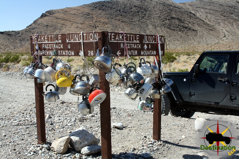
TeaKettle Junction lets you know you are starting to get close to the Racetrack.

Racetrack valley is a rough graded road which departs the Ubehebe Crater site and heads south into the desert. The road is rough, but easily passable in a regular car. However, when entering back country areas such as this it is always a good idea to have the insurance of a reliable vehicle, high clearance, four wheel drive, etc…  Do yourself a huge favor and air down your tires if you are properly equipped to air up when the trip is over.

Looking north from the Lippincott Mine towards the Racetrack off in the distance.

The racetrack valley road is a 25 miles one way trip to the playa. The road is grated, but can be heavily wash-boarded depending on the time of year, rain fall, etc…

Along the way, there are many side trips and alternate trails to help expand your visit.

As you leave Ubehebe Crater, you will be driving south and gradually gaining elevation. Take your time and enjoy the drive, if you are lucky you may see a big horn sheep herd. The road gradually gains in elevation and climbs through a Joshua Tree Forest.

Once you reach the pass, the road continues to drop in elevation all the way down to the playa. Continue straight through tea kettle junction, and bear left down the valley past the side road to the Lippincott mine, which is a great side trail.

The Racetrack Playa of Death Valley.

As you continue past the road to the Lippincott mine the road drops down to the Racetrack Playa itself. The first stop is ‘The Grandstand’ which is an outcropping of rock located in the north west corner of the racetrack. The second stop is the parking area to hike towards the stones. Don’t try to hike to the stones from the first Grandstand parking lot, or you will be hiking significantly further.

The highlight of the trip, is a short hike to the sailing or racing stones. The start of the hike is the parking area at the southern end of the racetrack playa.

Jeeps and Labradors are not allowed on the playa!

To reach the stones hike east from the parking lot across the playa towards the dark stone hillside. It is short FLAT, meaning really FLAT hike towards the stones. Be sure the check the temperatures before you leave, and bring lots of water. This is true with anything you might want to do in Death Valley. Don’t walk on the playa if it is wet or muddy.

The Racing stones.
The Racing stones.

At the end of the 30 miles road there is a small primitive campground for overnight visits. Be sure to check with the National Park Service for regulations of back country camping within the park.

Every racetrack needs a grandstand.

Notoriety

On September 19th, 1969 a Michigan front end loading is found burning along the road near the playa. Apparently, Manson order the machine burned. Park Rangers were deployed to the Racetrack. The rangers followed a set of tire tracked which belonged to a Toyota Land Cruiser which was stolen by Manson. The follow up investigate lead to the arrest of Charles Manson at Barker Ranch on October 12th, 1969.

Racetrack Valley Trail Map

References