Aurora, Nevada, was a prominent mining boomtown in Mineral County, founded in 1860 during the early silver and gold rushes of the American West. Known for its rich mineral deposits and vibrant community, Aurora briefly flourished as one of Nevada’s most significant early settlements, reaching a peak population of around 5,000 by 1863. However, its prosperity was short-lived, and by the late 19th century, it had become a ghost town. This report examines Aurora’s origins, economic and social development, decline, and historical legacy, drawing on primary sources, historical accounts, and archaeological evidence.

Origins and Early Development (1860–1861)
Aurora was established in September 1860 following the discovery of gold and silver in the Esmeralda Mining District by prospectors James M. Braley, William B. Hurd, and James Corey. The trio staked claims in what became known as Esmeralda Gulch, sparking a rush to the area. The town was named “Aurora” after the Roman goddess of dawn, reflecting the optimism of its founders. Its location, straddling the border of Nevada and California (then part of Utah Territory), led to jurisdictional disputes until a survey in 1863 confirmed Aurora’s placement in Nevada.
By 1861, Aurora had grown rapidly, with an estimated population of 1,400. The town’s early development was marked by the establishment of a post office, general stores, saloons, and rudimentary housing. The rich ore deposits, particularly silver, attracted miners, speculators, and entrepreneurs. Early mining operations were labor-intensive, but the high-grade ore justified the effort, laying the foundation for Aurora’s brief prominence.
Peak Prosperity (1862–1864)
Aurora reached its zenith between 1862 and 1864, driven by the productivity of its mines and its role as a regional hub. By 1863, the town’s population swelled to approximately 5,000, with some estimates as high as 6,000. The Esmeralda Mining District boasted over 1,000 mining claims, with major mines like the Real Del Monte, the Wide West, and the Antelope producing significant quantities of silver and gold. Between 1860 and 1869, Aurora’s mines yielded an estimated $27 million in ore (equivalent to over $500 million in 2025 dollars), making it one of Nevada’s most lucrative mining centers at the time.
The town’s infrastructure reflected its prosperity:
- Civic Institutions: Aurora served as the county seat of Esmeralda County from 1861 to 1863, with a courthouse, jail, and other government buildings. It later became part of Mono County, California, before being reassigned to Mineral County, Nevada.
- Business and Media: The town supported two newspapers, the Esmeralda Star and the Aurora Times, as well as numerous businesses, including 20 general stores, 65 saloons, and several hotels. A Wells Fargo office facilitated financial transactions.
- Social Life: Aurora was known for its lively social scene, with theaters, dance halls, and fraternal organizations. The town’s diverse population included miners, merchants, and professionals from across the United States and abroad.
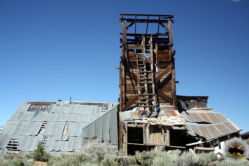
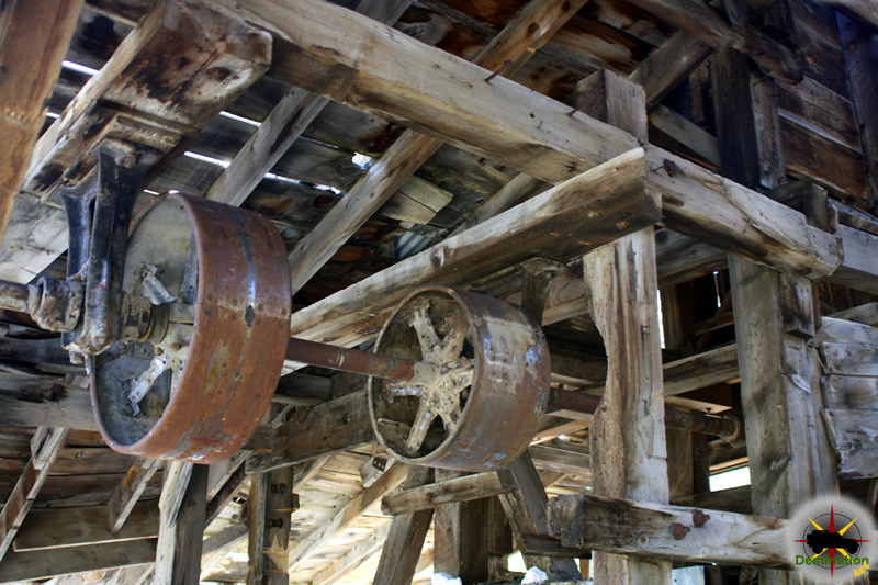
- Infrastructure: A brick schoolhouse, churches, and a cemetery were established, alongside mills for processing ore. The town’s main street, lined with adobe and wooden buildings, bustled with activity.
Aurora’s prominence was further enhanced by its association with notable figures, including a young Samuel Clemens (later Mark Twain), who briefly mined and wrote for the Esmeralda Star in 1862. His accounts in Roughing It provide a vivid, albeit humorous, glimpse into Aurora’s frontier life.

Decline and Abandonment (1865–1900)
Aurora’s decline began in the mid-1860s as the richest ore veins were depleted. By 1864, many mines were no longer profitable, and the population began to dwindle. The closure of major mills, such as the one relocated to Columbus, Nevada, in 1866, further eroded the town’s economic base. By 1869, the population had dropped to around 500, and the post office closed in 1897, signaling Aurora’s near abandonment.
Several factors contributed to Aurora’s rapid decline:
- Resource Depletion: The high-grade ore that fueled Aurora’s boom was exhausted, and lower-grade deposits were uneconomical to mine with existing technology.
- Economic Shifts: The rise of other mining towns, such as Virginia City and Tonopah, drew investment and labor away from Aurora.
- Jurisdictional Confusion: The town’s ambiguous status between Nevada and California created legal and administrative challenges, discouraging long-term investment.
- Natural Challenges: Aurora’s remote location and harsh climate, with limited water and arable land, made sustained habitation difficult.
By the 1880s, Aurora was largely deserted, though sporadic mining attempts persisted. A brief revival in the early 20th century, spurred by new milling technologies, failed to restore the town’s former glory. The final blow came in the 1940s when the last standing structures, including brick buildings, were dismantled for materials to support World War II efforts.

Archaeological and Historical Significance
Today, Aurora is a ghost town with minimal visible remains. Archaeological surveys have identified foundations, mine tailings, and scattered artifacts, such as bottles and tools, which provide insight into the town’s layout and daily life. The site, located approximately 22 miles southwest of Hawthorne, Nevada, is accessible via rough roads but is largely unmarked, with no official historical marker. The surrounding Esmeralda Mining District remains of interest to historians and geologists for its role in Nevada’s early mining history.
Historical records, including newspapers, mining reports, and personal accounts, are preserved in institutions like the Nevada State Archives and the Bancroft Library at UC Berkeley. Works such as Stanley W. Paher’s Nevada Ghost Towns & Mining Camps and Robert E. Stewart’s Aurora: Nevada’s Ghost City of the Dawn offer detailed accounts of Aurora’s rise and fall.

Legacy
Aurora, Nevada, encapsulates the fleeting nature of mining boomtowns in the American West. Its rapid growth and equally swift decline highlight the challenges of resource-dependent economies in the 19th century. The town’s contributions to Nevada’s early mining industry, its role in shaping regional development, and its association with figures like Mark Twain ensure its place in historical narratives. Aurora’s story serves as a case study in the boom-and-bust cycles that defined the frontier era, offering lessons on resilience, adaptation, and the impermanence of prosperity.

In 1863 Aurora is pictured as a cluster of huts made of stone, sheltered by canvas or tin roofs, with streets of wooden buildings , and many substantial brick structures near the center of town, and uncountable tents and dugouts in the surrounding hils. About 5,000 persons lived in these makeshift shelters and in the 700 houses, and enjoyed the services provided by the hotels , churches, 20 stores, 22 saloons and 16 quartz mills .
National Register of Historic Places Inventory – Nomination Form – July 30, 1974
Conclusion
From its founding in 1860 to its peak in the early 1860s and eventual abandonment, Aurora, Nevada, was a microcosm of the American West’s mining frontier. Its rich mines and vibrant community briefly made it a cornerstone of Nevada’s early history, but its decline underscores the volatility of resource-driven settlements. Though little remains of Aurora today, its legacy endures through historical scholarship, archaeological remnants, and its enduring place in Nevada’s cultural heritage.

Aurora Town Summary
| Name | Aurora |
| Location | Mineral County, Nevada |
| Latitude, Longitude | 38.2871421, -118.9006963 |
| GNIS | 858760 |
| Elevation | 7400 feet |
| Post Office | – 1919 |
| Newpapers | Esmeralda Star May 17, July 5, Sept 20, 1862; Nov 18, Dec 30, 1863 Aurora Daily Times Nov 27, 28, 30, Dec 1, 9, 11, 12, 1863; July 11, Oct 7, 1864 Esmeralda Daily Union Mar 23, 1864 – Mar 15, 1865; Nov 27, 1867 – Oct 3, 1868 Esmeralda Herald Oct 20, 1877 – July 29, 1882; Aug 18, 1883 – Apr 19, 1884 Aurora Borealis Dec 3, 1905 |
Aurora Trail Map
Aurora Personalities
 Samuel Langhorne Clemens – “Mark Twain”Before he wrote American classic novels as Mark Twain, Samuel Langhorne Clemens was a miner and newpaper reporter in Mineral County, Nevada. Prior to picking… |
Aurora Newspapers
Aurora Borealis NewspaperThe Aurora Borealis newspaper was published in Aurora, Nevada, during the early 20th century. . As a product of a once-thriving mining town, the Aurora… |
Aurora Daily Times NewspaperThe Aurora Daily Times newspaper was a short-lived but significant newspaper published in Aurora, Nevada, during the early 1860s, a period marked by the region's… |
Esmeralda Daily Union NewspaperThe Esmeralda Daily Union newspaper was a short-lived but significant publication in Aurora, Nevada, during the mid-19th century. Operating in a bustling mining town during… |
 Esmeralda Star NewspaperEsmeralda Star Newspaper The Esmeralda Star was a pivotal publication in the early history of Aurora, a bustling mining town in Esmeralda County, Nevada, during… |
Further Reading
 Aurora, Nevada 1860-1960: Mining Camp, Frontier City, Ghost TownThis expanded Second Edition of Aurora, Nevada 1860-1960 chronicles the history of one of Nevada’s earliest and most important mining boomtowns. It is a reference-oriented… |
 Nevada Ghost Towns and Mining CampsNevada Ghost Towns and Mining Camps - By Stanley W. Paher Nevada Ghost Towns and Mining Camps is a wonderful book written by Stanley W.… |