Carson City Station – Pony Express Station

Carson City Station was a pony express station located between on Carson Street between Forth and Fifth Street in Carson City, Nevada. Founded in 1858, Carson City was was named for frontiersman, Kit Carson. The town operated as a social and supply center for the nearby mining settlements of the Comstock Lode in the mid-1800’s. In 1864 it was designated the state capital. The station is designated as a home station, where extra horses, firearms, men and provision are kept.

King Street, General View, 1880, Carson City, Carson City, NV

In 1860. the town only had one street, which is lined with a double row of saloons, a few assay offices, a general store, and the hotel. The pony express station operated out of a hotel that located between 4th and 5th Streets, near the original Ormsby House.

Pony Express

Sources generally agree on the identity of Carson City as a pony express stop. Little information is available about the Carson City Station site, which was located on what is now Carson Street between Fourth and Fifth. Bolivar Roberts, division superintendent, used site as a base in March 1860 to hire riders and station keepers. Since he worked as part of a team to build or acquire other stations along the route, Roberts also probably helped established the location.

Carson City, Nevada - 1880
Carson City, Nevada – 1880

NameCarson City Station
LocationCarson City, Nevada
Latitude, Longitude
NPS Statopm Number164
Next Westbound StationGenoa
Next Eastbound StationDayton Station

References

Sutro Nevada

Located at 4,478 feet, Sutro Nevada is a ghost town located in Lyon County Nevada built to support construction of the Sutro Tunnel.

The town of Sutro Nevada, taken in 1874

The story of Nevada can not be told without the Comstock Load. The Comstock Load was a massive silver mine located under the eastern slope of Mount Davidson, near Virginia City, Nevada. The strike is made public in 1859 and lead to the largest rush into Nevada since the California Gold Rush of 1849.

Miners following the silver ore tunneled deeper and deeper into the mountain. Natural springs frequently flooded the tunnels and many miners escaped with their lives after tapping into a large underground reservoir of water. The deeper the miners tunnelled, the more expensive to remove the scalding hot water from their tunnels.

Adolph Heinrich Joseph Sutro (1830–1898) was the 24th mayor of San Francisco, California, serving in that office from 1894 until 1896 - Photographer Mathew Benjamin Brady
Adolph Heinrich Joseph Sutro (1830–1898) was the 24th mayor of San Francisco, California, serving in that office from 1894 until 1896 – Photographer Mathew Benjamin Brady

Adolph Heinrich Joseph Sutro proposed a solution to the water problem. His proposal was to build a drainage tunnel from the deepest part of the Comstock Lode.

The Sutro Tunnel

In 1865, Sutro’s tunnel gained traction and had gained approval from the federal and state governments. The Sutro Tunnel Company is formed and started selling stock certificates to raise funds. Construction began in 1869 and connected to the Savage Mine on July 8th, 1878. On June 30th, 1879, the tunnel is connect of all of the mines and the first water is released. The tunnel was 3.88 miles in length and runs from Dayton to Virginia City.

Town Summary

NameSutro Nevada
LocationLyon County, Nevada
Latitude, Longitude39.28, -119.584167
GNIS856145
Elevation4,478 ft (1,365 m)
Population600 – 800
Post OfficeMarch 1872 – October 1920
NewspaperSutro Independent Sept 25, 1875 – Nov 22, 1880

Sutro Map

References

Sutro Tunnel

The Sutro Tunnel was a drainage adit into the Comstock Load, which is located in Lyon County, Nevada. Following Silver discovers and in the Comstock Load, a rush of people came into Nevada. Production from the Comstock is hindered by water flooding the tunnels at depth.

The entrance to the Sutro Tunnel in the late 1800s. Suntro, Lyon County, Nevada.

In 1865, Sutro’s tunnel gained traction and had gained approval from the federal and state governments. The Sutro Tunnel Company is formed and started selling stock certificates to raise funds. Construction began in 1869 and connected to the Savage Mine on July 8th, 1878. On June 30th, 1879, the tunnel is connected all of the mines and the first water is released.

Adolph Sutro sold his interest in the company following the completion of the project, however he stayed on the board of the organization. Later, he moved to San Fransic The tunnel is 3.88 miles in length and runs from Dayton to Virginia City.

Nevada State Historic Marker Text

Sutro was a town, a tunnel and a man. The orderly town was headquarters for the Sutro drainage tunnel. Adolph Sutro, German born, came to the Comstock in 1860. He advocated a drainage tunnel, visualizing development of the Comstock resource by a system long used to drain and explore mineral deposits.

By 1865, his vision gained approval of state and federal legislation. However, the mining interests, having at first supported the tunnel, became strongly opposed.

When construction began in 1869, it was first financed by the mine workers, since the tunnel would improve mine safety. Later, the funding came from international bankers.

The main tunnel broke through in 1878. Lateral tunnels were extended and the project drained, ventilated and serviced the Comstock as planned. When the tunnel was proven, Adolph Sutro sold his interest in the tunnel company and returned to San Francisco. A “magnificent hole in the ground” remains.

Nevada State Historic Marker Summary

NameSutro Tunnel
LocationLyon County, Nevada
Nevada State Historic Marker85
Latitude, Longitude39.2744, -119.5645

Trail Map

References

Fort Churchill Nevada

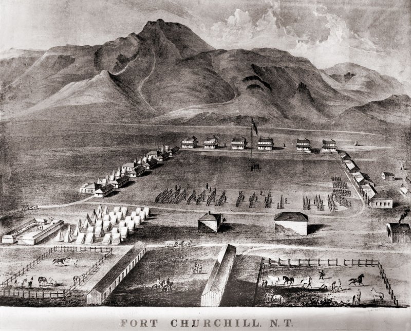
Fort Churchill is a Civil War era United States Army Fort, Pony Express Station and overland stage stop located in Lyon County, Nevada just West of Buckland’s Station. The station is designated as a home station, where extra horses, firearms, men and provision are kept. The fort was commissioned to protect early settlers from the east from Indian attacks. The garrison was the largest, most elaborate fortification in the Nevada Territory at the time.

A lithograph drawing of Fort Chuchill, Nevada Territory created by Grafton Tyler Brown in 1862

The discovery of gold in California caused a massive rush of people across the United States. Some of these early settlers came into the Nevada Territory and setup stage stops and mining operations. The arrival of settlers in their territory threatened the the Northern Paiute people. The increase populations of settlers increased the competition for local resources, such as game. These tensions, along with kidnapping and of rape of two young Paiute girls by prospectors from Williams Station erupted into Pyramid Lake War in 1860.

The U.S. Army fort was build along the Carson River and construction of Fort Churchill started on July 20, 1860. The base was named in honor of Sylvester Churchill who was the Inspector General of the Army. The fort is completed in early 1861 and home to some 200 soldiers charged with protecting settlers and mail routes. The post is abandoned in 1869.

On October 6, 1932, Nevada took control of the 200 acre fort and took steps to preserve the ruins as a state park.

Pony Express

Sources generally agree on the identity of Fort Churchill as a Pony Express stop. Built during the summer of 1860 by Captain Joseph Stewart and his men, the adobe fort housed the Pony Express station in its headquarters building. Construction on the fort began on July 20, 1860, approximately twenty-five miles from Comstock, Nevada, along the edge of the Carson River. When Richard Burton arrived at Fort Churchill on October 19, 1860, he gave it a positive review in his journal and named Captain F.F. Flint as the commander.

Since the Pony Express used Buckland’s as a home station, Fort Churchill probably assumed a similar function when the Pony Express transferred its station from Buckland’s to the fort. The Fort Churchill’s ruins existed as late as 1979, including the headquarters building, and it is a Nevada state park. 

Fort Churchill Map

NameFort Churchill
LocationChurchill County, Nevada
Other NamesFort Churchill Station
NPS Pony Express Station153
Next Westbound StationFairview Station
Next Eastbound StationBuckland’s Station
National Historic Landmark66000456

References

Buckland’s Station

Buckland Station is a pony express station, stage stop, boarding house and supplier near Fort Churchill in Lyon County, Nevada. The station is designated as a home station, where extra horses, firearms, men and provision are kept.

Buckland Station early 1900s

In 1857, Samual Buckland moved from California to the future site of Buckland’s Station. Buckland, a cattle rancher, improved the property by building a tradingpost, tent hotel, stage stop and toll bridge over the Carson River. A small log cabin was constructed in 1860.

Buckland’s Station served as a stop for the pony express when Buckland contracted with Bolivar Roberts in March 1860 for his ranch to serve as a Pony Express home station. Fort Churchill was established two miles to the west during the summer of 1860 as a result of the Pyramid Lake Indian War. With the establishment of Fort Churchill and its protective bulwarks, the pony express station was relocated.

On October 19, 1860, when Richard Burton visited Buckland’s, he described the station, as usual, in negative terms.

nps.gov

In 1861, Bucklands Station was honored as the county seat of Churchill County. It also served as the county seat for Lyon County Fort Churchill closed in 1869 and Samuel Buckland bought some of its building material and built a large impressive wooded framed house.

Buckland died on December 28, 1884 at 58 years in age. He and his family are buried at the Fort Churchill Cemetery. Today, the large house built by Buckland is restored and

Buckland Station Location Summary

NameBuckland’s Station
LocationLyon County, Nevada
Latitude, Longitude39.2946400, -119.2515470
GNIS856483
Elevation5000 feet
AliasBarnett, Barrett, Buckland Ranch, Bucklands, Tolles, Tolles Station, Weeks
Pony Express Stop No152

Buckland’s Station Trail Map

References