Chemung Mine

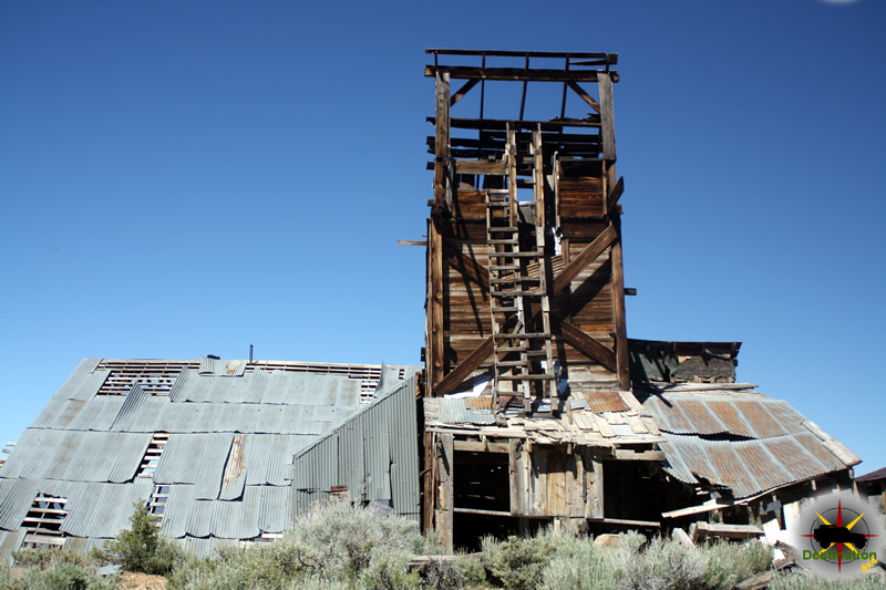
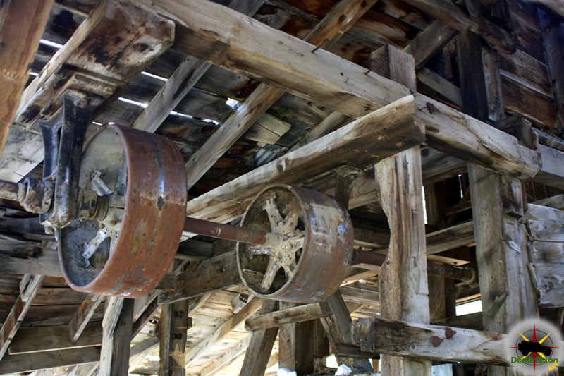
Located off the Masonic Road between Bridgeport, CA and the Masonic town site, are the remains of the Chemung gold mine.  The Chemung gold mine operated from from 1909 to 1938 and produced over one million dollars in gold.  In the 1920s, the Chemung mine was producing low grade and high grade ore.  The ore was processed onsite, and then shipped to near by Bodie for smelting.

The Chemung Mine located just outside of Bridgeport, CA. Photograph by James L Rathbun

Along with the increase cost of mining supplies which reduced growth, a poor gold market and the cost of hauling the ore to Bodie over the poor roads for smelting and little mine was doomed and closed its doors in 1938.

The Chemung mine history is not a mining failure, but a failure of management and litigation.  During its time of production, the mine built and tore down three mills.  During the last year of operation in 1938, 20 men worked the site and less than one year later the mine was closed.  The mine itself produced well, however endless litigation for various reasons doomed the mine.

The Chemung gold mine over looking the Bridgeport Valley.. Photograph by James L Rathbun

Throughout the 1950s and 1960s new life was found in the mine with the efforts of Elton “Heinie” Heinemeyer.  Heinemeyer mined for years but never struck it big.  Well liked by the town of Bridgeport, CA Heinemeters well being was the source of concern for the people of Bridgeport and it is reported that he would always find time to visit and entertain those who traveled to check up on him.

Currently, the mill building structure is intact but the years of harsh weather have taken its toll.  A mild wind will cause some of the walls to shake or shudder, and the lower outer wall is leaning outward.  In June 2016, bars restricted access to the mines themselves although the mines do offer a cold breeze on a warm day to cool you down.

The Chemung mine still maintains and impressive structure. Photograph by James L Rathbun

There are stories that the site is haunted by a spirit or ghost, but only on Saturday nights, which seems a bit odd to me.

The Chemung Mine working still seem ready to go. Photograph by James L Rathbun

On a personal note, the Chemung mine surprised me.  I have been to Aurora three times, Masonic at least three times, and Bodie… at least ten.  My last visit to Bodie was in 2013. Afterwards this last trip, I was looking in Google Earth when I “discovered” the Chemung gold mine.  How had this mine, such an impressive structure, evaded my radar for so many years?  It took me three years from that day to make my first visit to Chemung, and this place is definately on my list for a repeat visit.

Time, weather and gravity have taken its toll on the structure of the Chemung Mine.. Photograph by James L Rathbun
Time, weather and gravity have taken its toll on the structure of the Chemung Mine. Photograph by James L Rathbun

Chemung Mine Trailmap

Resources

Silver Star Mine

The Silver Star Mine is a small mine site located off of the Zinc Mountain Road in San Bernardino County, California. The site rests at 4931 feet above sea level in the Ivanpah montains. The lonely site features a small humble cabin the miners used to survive and beat the heat. There is also a wrecked automobile near at the site, which has long since given up the battle against rust.

Silver Star Mine Cabin

There is not much information available for this location on the Internet and hopefully I will be able to find some eventually. The mine site is also know as the Lucky Lode deposits. The route into the area is reasonably passable and should be suitable for most cars, provided the driver is used to operating on the back roads of the desert.

Silver Star Mine
Silver Star Mine rusted out auto

Some places claim that this mine produced lead, copper and zinc. The fact that this mine is found just off of Zinc Mountain Road offers some credence to a zinc mine. Other online sources claim this is a tungsten mine. A shallow mine shaft is located near the cabin. The shaft contains an old wooden ladder used by the miners and appears to be filled in, collapsed, or suspended after about 20 feet of workings.

Silver Star Mine Shaft
Silver Star Mine Shaft with ladder.

This stark hole in the ground reminds us what a challenges the life of a miner must endure. Hot, dry deserts, narrow, dark tunnels in a hostile landscape.

Silver Star Mine Trail Map

Resources

Lost Burro Mine

Founded in 1907 when Bert Shively picked up a rock to throw at some stray burros and discovered gold, the Lost burro Mine is a great destination in Death Valley. The mine was operated from 1907 to the 1970s, with its greatest production of gold being from 1912 – 1917. The road into the mine is just 1.1 mile from Hunter Mountain road located in Death Valley National Park.  The trail is very easy to pass and suitable for most stock SUVs, although it does get narrow in two places.

The Lost Burrow Mine is located off Hunter Mountain Road in Death Valley National Park, CA

As you approach the site, there is evidence of human occupation and the large amount of tin cans and artifacts gradually increase the closer you get to the mine site.  There is a long history of haunting and curses place upon people who remove artifacts from the location.  There are at least four structures still standing at the site.  The main cabin, a storage cabin, outhouse and the mine located high above on a cliff.  You can enter the cabin and storage cabin but posted warnings of Hantavirus warn of the potential danger.

The Lost Burrow Mine

The Upper Mill

The upper mill site is accessible using a steep short trail and well worth the effort.  The structure appears to be reinforced with guy wires to help maintain its state.  Much of the pulley system remains intact and the terrain and remote location reminds us of what these men endured to survive in this location.

The cabin found at the Lost Burrow Mine is in good shape.

There is evidence of many people returning removed items in the hopes of removing the curse. There are two buildings at the site with the Mill located just to the North.  Two short hikes to the hills above offer amazing views of the Racetrack Valley and Hunter Mountain.

The Lost Burrow Mine cabin interior

Lost Burro Mine Video

Lost Burro Mine Trail Map

Goldome Mill

The heavily vandalized Goldome Mill outside of Ivanpah, California.  Photo by James L Rathbun
The heavily vandalized Goldome Mill outside of Ivanpah, California. Photo by James L Rathbun

The Goldome Mill is an abandoned modern mill site in the New York mountains of San Bernardino, California just off of the Ivanpah Road. The site was abandoned in the 1998 following the formation of the Mojave National Preserve by the California Desert Protection Act in 1994 and has slowly fallen into a state of decay. The mill site is currently classified as a Superfund Site by the Environmental Protection Agency which means that the site is known to contain hazardous waste which is improperly contained.

  Photo by James L Rathbun
Photo by James L Rathbun

The mill was named Goldome, meaning “an abnormal growth of gold” out of an optimism as to the fortunes of those who invested in this venture. The construction of the site is very modern and industrial in appearance. All of the buildings are of metal construction and probably built during the late 1970s or early 1980s. All of the milling equipment, such as the trommel and sluice boxes appear to silently rest in state. This site was likely the mill site of choice for near by mines of its era, such as the Morning Start Mine or the

Graffitti on a wash plant at the Goldome Mill.    Photo by James L Rathbun
Graffitti on a wash plant at the Goldome Mill. Photo by James L Rathbun

In 2017, political vandals posing as “street artists” decided on their own to deface the site as part of their environmental message and forever changed the face of this site. The mill at Goldmine is heavily vandalized and at the time of our visit during the riots following the murder of George Floyd gave the site an uneasy felling. It is not too far a reach to understand that they vandals who defaced this site could be burning our cities down.

At the Goldome Mill, the work of vandals is undone by the harsh Mojave Desert.  Photo by James L Rathbun
At the Goldome Mill, the work of vandals is undone by the harsh Mojave Desert. Photo by James L Rathbun

During our visit to the site, a large swam of bees built a hive in the main building. This prevented me from entering and exploring further, however, I will return to do so, at some point.

Goldome Mill Map

Additional Reading

Vanderbilt California – San Bernardino County Ghost Town

A metal headframe marks a vertical shaft in the mining district outside of Vanderbilt California.

Located in the New York Mountains, Vanderbilt California was an short lived gold mining town which lasted just a few short years, from 1891 to 1895. The mining district is found in the northeastern section of San Bernardino County, right at the California and Nevada Border and almost within sight of Primm, Nevada.

Old Plumbing remains in the town of Vanderbilt, CA

Gold was discovered in the New York Mountains, in January 1891 by a Piute Indian named Robert Black. Soon after, the news of the strike traveled quickly and there were several mines in operation, including the Gold Bronze, the Sagmore and the Boomerang. The district was named for the the Vanderbilt Family, in the hopes the gold strike would prove as rich as the Vanderbilt Fortune. A small camp was built to support the operation and with additional gold veins found in the fall of 1892, word got out and the rush started.

Vanderbilt Business District

Two years later, in 1893, the small mining camp has attracted 150 people and boasted two stores, one saloon, three restaurants, stable, lodging house, a blacksmith shop and about 50 tents. The post office was added in February of 1893 and a Justice of the Peace, W. A. Nash was appointed. A weekly newspaper, the Shaft was soon published. A railway line and water works were planned, but never completed.

A horizontal mine shaft in Vanderbilt

A population of about 500 was found in the small town in 1894. In addition of adding more buildings and saw more saloons and businesses followed to service the town. Two ten-stamp mills were constructed at the two large mine sites, however the service was short lived. Almost as soon as the mills were built, the mines struck water and the ore changed and made it such that the mines could not recover gold. The town died with the gold production in 1895. 1895 also saw work on the railroad to Vanderbilt ceased. The school closed in 1898 and the Post office closed in 1910.

Exploring the ghost town of Vanderbilt, CA

Perhaps the towns biggest modern claim to fame was one of its famous citizens. Virgil Earp, older brother of Wyatt Earp and survivor of the infamous gunfight at the O. K. Coral, owned and operated a two story building which was served as saloon and hotel in the small town of Vanderbilt. It should be known that there were a lot of Earp Brothers, and there was a lot of migration during this period as populations moved quickly from town to town looking for fortune and opportunity.

Virgil Earp 1843 -1905

Town Summary

Town NameVanderbilt
LocationSan Bernardino County, California
Latitude, Longitude35.327222, -115.249722
Population500
Elevation4350 Feet
NewspaperThe Shaft
Post OfficeFebruary 1893 – 1910

Vanderbilt Trail Map

Further Reading