Camp Osito Road – 2N17

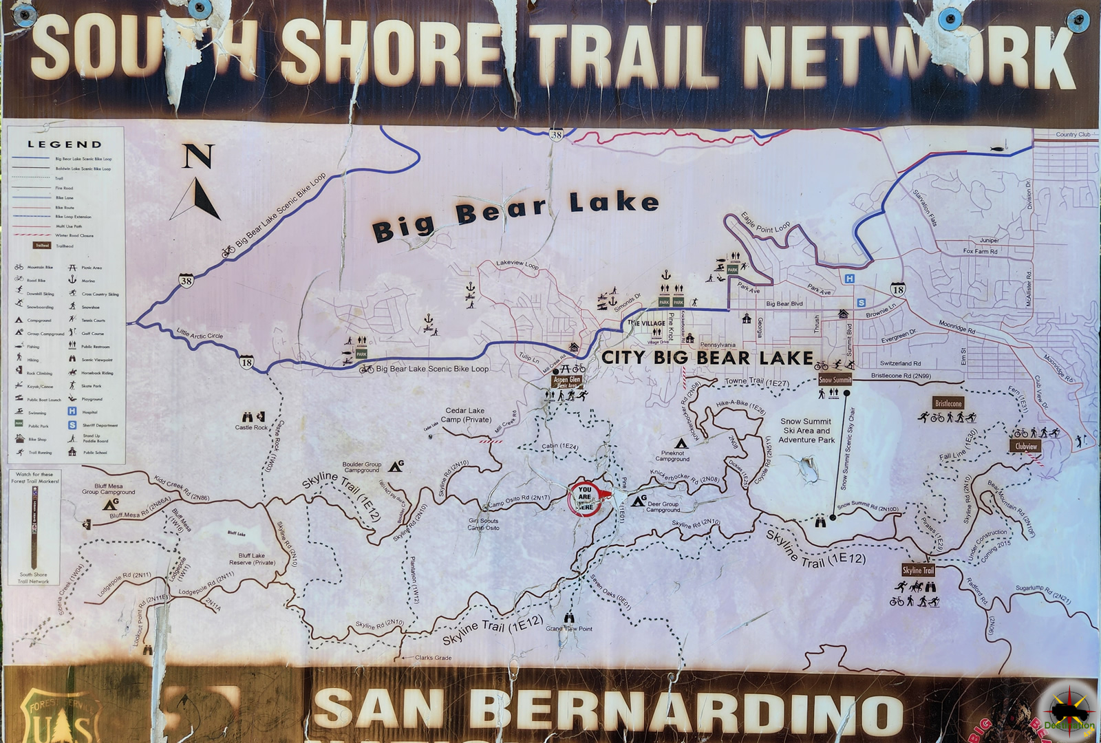
Camp Osito Road is a back country 4×4 trail which connects Knickerbocker Road to Skyline Drive in Big Bear, California. The seldom travelled road is an access route to a local Girl Scout Camp.

Camp Osito Road - 2N17 - Trailhead from Knickerbocker Road near Big Bear, California
Camp Osito Road – 2N17 – Trailhead from Knickerbocker Road near Big Bear, California

Route 2N17 branches from the Knickerbocker trail about two miles from either end and wanders towards the west by Camp Osito. From there, the route continues through the heart of the San Bernardino Mountains until it intersects with Skyline Drive. This is at best an intermediate trail and offers views of Big Bear Lake and the surrounding forests and manzanita groves.

Big Bear Mountains, nestled in the heart of Southern California, offer a breathtaking escape into nature’s splendor. With a majestic backdrop of towering pines and rugged terrain, this mountainous haven beckons outdoor enthusiasts and adventure seekers alike. The towering peaks, including San Gorgonio Mountain, provide year-round recreational opportunities, from exhilarating ski slopes in the winter to invigorating hiking trails during warmer months.

Due to the proximity to Big Bear, it is quite common for this route to be used by hikers, bickers, quad riders and 4x4s alike, so keep an eye out for traffic.

Trail Summary

NameCamp Osito Road
LocationBig Bear, San Bernardino, California
Latitude, Longitude34.2243, -116.9378
Elevation7,500 feet
Distance1.8 Miles
Elevation Gain352 feet

Trail Map

Camp Osito Road is part of the South Shore Trail Network located in the San Bernardino Mountains, near Big Bear, California.


Camp Osito Road - 2N17 - Trailhead from Knickerbocker Road near Big Bear, California

Camp Osito Road – 2N17

Camp Osito Road is a back country 4x4 trail which connects Knickerbocker Road to Skyline Drive in Big Bear, California. The seldom travelled road is…
Clarks Grade 1N54 Trail Head dropping down into Barton Flats from Skyline Drive.

Clarks Grade 1N54

Clarks Grade 1N54 Trail Head dropping down into Barton Flats from Skyline Drive. Clarks Grade 1N54 is a steep and scenic descent from the top…
Big Bear Lake viewed from Knickerbocker Road.

Knickerbocker Road – 2N08

Knickerbocker Road - 2N08 is a steep and beautiful drive from near the town of Big Bear, California to Skyline Drive. The route is a…
Skyline Drive 2N10 offers higher elevation views of Big Bear, California

Skyline Drive 2N10

Skyline Drive 2N10 offers higher elevation views of Big Bear, California Skyline Drive 2N10 is the unofficial name for USFS Road 2N10 that begins just…

Knickerbocker Road – 2N08

Knickerbocker Road – 2N08 is a steep and beautiful drive from near the town of Big Bear, California to Skyline Drive. The route is a popular destination and common for hikers, bikes and vehicles alike. The route winds up the mountain from the village in Big Bear up to the top of the mountain offering some spectacular vistas and the valley below.

Big Bear Lake viewed from Knickerbocker Road.

Knickerbocker Road – 2N08 is accessed from Highway 18 in Big Bear, about two blocks east of the village. The trail head is located 3/4 of a mile from the highway off of Knickerbocker Road. The trail begins with a tight left turn and steeply gains alititude. from the valley floor on its journey up to Skyline Drive.

Intersection with 2n17 about two miles from either end of Knickerbocker Road.

Along the route, you journey deep into a lush pine forest with a few seasonal streams to nourish the lush green plant life. Manzanita Bushes fill the landscape, along with a variety of seasonal wild flowers as you continue to climb to the ridge of the mountain. Don’t forget to admire the views of Big Bear lake as you make the journey.

Once the trail terminates at the Grand View Vista at Skyline drive, there is a very small parking area to relax, picnic and enjoy the alpine view of Barton Flats and valley below. From here, you can return as you came, or pick any of several trails from the South Shore Trail Network including Skyline Drive,

Knickerbocker Road Trail Summary

NameKnickerbocker Road – 2N08
LocationBig Bear, San Bernardino County, California
Latitude, Longitude34.2162, -116.9192
Length4 Miles
Elevation Gain890 feet

Trail Map

Knickenbocker Road is part of the South Shore Trail Network.


Camp Osito Road - 2N17 - Trailhead from Knickerbocker Road near Big Bear, California

Camp Osito Road – 2N17

Camp Osito Road is a back country 4x4 trail which connects Knickerbocker Road to Skyline Drive in Big Bear, California. The seldom travelled road is…
Clarks Grade 1N54 Trail Head dropping down into Barton Flats from Skyline Drive.

Clarks Grade 1N54

Clarks Grade 1N54 Trail Head dropping down into Barton Flats from Skyline Drive. Clarks Grade 1N54 is a steep and scenic descent from the top…
Big Bear Lake viewed from Knickerbocker Road.

Knickerbocker Road – 2N08

Knickerbocker Road - 2N08 is a steep and beautiful drive from near the town of Big Bear, California to Skyline Drive. The route is a…
Skyline Drive 2N10 offers higher elevation views of Big Bear, California

Skyline Drive 2N10

Skyline Drive 2N10 offers higher elevation views of Big Bear, California Skyline Drive 2N10 is the unofficial name for USFS Road 2N10 that begins just…

Warm Springs Canyon Road

The hottest place on earth, Death Valley National Park is on the order with California and Nevada

Warm Springs Canyon Road is a rugged, scenic backcountry route in the Panamint Range of Death Valley National Park, California, offering a challenging off-road adventure through stark desert landscapes, historic mining sites, and access to the tranquil Warm Springs Camp. This unpaved road is not a hiking trail but a 4×4-only route, winding through the heart of the Panamint Mountains from Panamint Valley to Butte Valley. Spanning approximately 17-20 miles one-way with elevations from 1,500 to over 4,000 feet, it features dramatic canyon walls, Joshua tree-dotted flats, and occasional wildlife like bighorn sheep or wild burros. As of August 14, 2025, the road is open following repairs from the August 2023 flash floods caused by Hurricane Hilary, but conditions remain rough with loose gravel, rocky sections, and potential washouts during monsoon season (July-September). Always check the National Park Service (NPS) website or visitor centers for real-time road status, as extreme heat (summer highs often exceed 110°F) and remoteness require meticulous preparation.

Route Description and Access

  • Starting Point: The road begins near the ghost town of Ballarat in Panamint Valley, accessible via paved roads from Trona or Highway 178. A sign marks the turnoff from Panamint Valley Road onto the graded dirt of Warm Springs Canyon Road, entering Death Valley National Park after a few miles.
  • Length and Elevation: Approximately 17-20 miles one-way to Butte Valley, with an elevation gain of about 2,500 feet. The first 10-12 miles to Warm Springs Camp are relatively manageable, while the final stretch to Butte Valley includes steeper, rockier terrain.
  • Primary Route: From Ballarat, the road heads east through Warm Springs Canyon, passing abandoned talc mines and climbing through narrow, rocky washes to Warm Springs Camp (mile 10-12). It then continues to Anvil Spring and Striped Butte in Butte Valley.
  • Alternative Routes: A southern spur from West Side Road (25 miles south of Furnace Creek) joins the main route near Warm Springs Camp but is rougher and less direct. For experienced drivers, the road can extend over Mengel Pass (extremely rugged, with boulder fields) to Goler Wash and Barker Ranch, though this requires advanced 4WD skills.
  • Travel Time: 2-4 hours one-way, depending on vehicle speed, road conditions, and stops for photography or exploration.

Difficulty and Vehicle Requirements

  • Difficulty: Moderate to difficult for off-roading. The initial 8-10 miles to Warm Springs Camp require high-clearance vehicles due to loose gravel, washouts, and occasional boulders. Beyond the camp, 4WD with low-range gearing is mandatory for steep grades and rocky sections, especially toward Butte Valley or Mengel Pass.
  • Vehicle Requirements: High-clearance 4×4 vehicles with all-terrain tires are essential. Standard cars or low-clearance SUVs are unsuitable and risk damage or stranding. Carry a full-size spare tire, recovery gear (shovel, traction mats), and air-down tires for better traction. Novice drivers should avoid solo trips due to the remote setting and lack of cell service.
  • Safety Note: Recovery services are expensive and may take hours to reach you. Carry extra fuel (nearest gas is 50+ miles away in Furnace Creek or Trona), water (1 gallon per person per day), and a satellite phone or communicator, as cell coverage is nonexistent.

Current Conditions (August 2025)

  • Road Status: Reopened in December 2023 after significant flood damage from Hurricane Hilary in August 2023. Recent reports confirm passability for properly equipped 4×4 vehicles, though sections remain washboarded, rocky, and prone to erosion. Monsoon season (July-September) increases flash flood risks, potentially causing temporary closures. No snow concerns in summer, but extreme heat poses a danger—travel early morning or late afternoon.
  • Weather Considerations: Daytime temperatures often exceed 110°F in summer, dropping to 80-90°F at night. Spring and fall offer milder conditions (60-80°F), with occasional wildflower blooms. Winter may bring light snow at higher elevations.
  • NPS Alerts: Check www.nps.gov/deva for real-time updates, as flash floods or heavy rains can alter road conditions rapidly.

Trail Map

Points of Interest

  • Warm Springs Camp: Located 10-12 miles from the start, this oasis features natural hot springs feeding concrete pools (around 100°F), shaded by palm trees. It’s a primitive campsite with pit toilets but no potable water—bring your own or treat spring water. A perfect spot for a break or overnight camping.
  • Talc Mines: Abandoned mining sites, including the Pfizer and Western Talc operations, dot the canyon with rusted equipment and structures. Explore on foot but avoid entering unstable shafts or removing artifacts.
  • Geological Features: The canyon showcases colorful rock layers, from volcanic tuff to metamorphic formations, with sparse vegetation like Joshua trees and creosote bushes.
  • Butte Valley Access: The road’s endpoint in Butte Valley offers access to Striped Butte (a colorful, 4,744-foot peak), the Geologist’s Cabin (a historic stone structure), and Stella’s Cabin at Greater View Spring.
  • Wildlife: Look for wild burros near the springs, bighorn sheep on rocky slopes, or desert tortoises in spring. Avoid disturbing wildlife and maintain distance.

Tips for Visitors

  • Permits: Free backcountry camping permits are required for overnight stays, available at Furnace Creek Visitor Center or online at www.nps.gov/deva. Day use requires no permit but a park entrance pass.
  • Safety Essentials: Bring ample water, food, first-aid kit, maps, and emergency supplies. Inform someone of your itinerary and expected return. Carry a satellite communicator for emergencies, as the nearest help is in Furnace Creek (50+ miles).
  • Best Time to Visit: October through April for cooler temperatures (60-85°F). Avoid summer unless highly experienced, as heatstroke is a serious risk. Group travel with 4WD clubs is recommended for safety.
  • Environmental Protection: Stay on designated roads to avoid damaging cryptobiotic soil crusts. Off-road driving is strictly prohibited. Pack out all trash and respect historical sites by leaving artifacts untouched.
  • Navigation: GPS can be unreliable; carry a detailed topographic map (e.g., National Geographic Death Valley map) and a compass. Road signs are minimal, and junctions can be confusing.

History of Warm Springs Canyon and the Panamint Range

The Panamint Range, including Warm Springs Canyon, has a rich history tied to Native American habitation, mining booms, and modern preservation efforts. The Timbisha Shoshone, indigenous to Death Valley, used the region for seasonal hunting and gathering as early as 1000 CE, navigating the canyons for resources like mesquite and water sources like Warm Springs. Their presence persisted despite later Euro-American encroachment.

Mining activity surged in the 1870s during the California Gold Rush’s tail end. The Panamint Range became a hotspot after silver and gold discoveries in nearby Panamint City (1873-1876), though Warm Springs Canyon itself saw more activity in the late 19th and early 20th centuries. By the 1880s, prospectors explored the canyon for gold, silver, and later talc, a soft mineral used in industrial applications. The Butte Valley Mining Company, incorporated in 1889, worked claims in nearby Goler Canyon and Warm Springs, targeting gold and silver veins yielding up to $20 per sack. Talc mining dominated by the 1930s, with operations like the Western Talc Company and Pfizer’s mines employing workers through World War II. Notable figures included Asa “Panamint Russ” Russell, who built the Geologist’s Cabin in Butte Valley in 1930 while prospecting gold, and Louise Grantham, who operated talc claims in the 1930s-1940s.

The early 20th century saw transient mining camps, with Warm Springs serving as a water source and rest stop for prospectors. The road itself evolved from wagon trails used by miners to access claims, later graded for vehicle use in the mid-20th century. By the 1960s, mining declined, and the area’s inclusion in Death Valley National Monument (established 1933, expanded to a national park in 1994) shifted focus to conservation. The Warm Springs Camp pools were constructed in the mid-20th century, possibly by miners or early park stewards, enhancing the site’s appeal for backcountry travelers.

Today, Warm Springs Canyon Road remains a testament to the region’s mining heritage, with relics like rusted machinery and stone cabins preserved under NPS oversight. Its remote beauty and historical significance make it a must-visit for those equipped to handle its challenges, offering a window into Death Valley’s rugged past and pristine present.

Goler Wash and Mengel Pass

Goler Wash and Mengel Pass over a route into Butte Valley from Panamint Valley. Although not technically in Death Valley, this trail is consider part of the area. Trail conditions vary from easy to difficult depending upon recent rainfall, with one section near Mengel pass being difficult.

The route twists and turns through a narrow valley, until it opens a bit into Goler wash itself. There is a short side trip to Baker Ranch and Meyer Ranch which was the one time, although short lived home of Charles Manson and his family prior to their arrest by Inyo County Sheriffs Department in October of 1969. Manson and others were responsible for the famous Tate – La Bianca murders in Los Angeles, California. Mason and his family drove a school bus up to Barker Ranch. The ranch was used as a mining and recreational property before Manson.

Barker Ranch - The building complex was heavily vegetated with trees, with a sparsely planted understory. Note the Manson bus in the left hand side of the image. View northwest, 1969 (DEVA collection). - NPS
Barker Ranch – The building complex was heavily vegetated with trees, with a sparsely planted understory. Note the Manson bus in the left hand side of the image. View northwest, 1969 (DEVA collection). – NPS

Barker Ranch

Barker Ranch is originally built in the 1930s by Bluth and Helen Thomason who were attempting mining operations at the site. They built a small stone building in the 1940’s and a windmill generated electricity. In 1955 the property was purchased by Jim and Arlene Barker. The Barkers expanded the original stone build for Barker family gatherings. In 1969, over the period of two days Charles Manson and his “family” are pursed and arrested. The arresting officer was CHP Officer Jim Jim Pursell.

In 2009, Barker Ranch is destroyed by a fire which tore though the dry wood of the buildings.

Asa Russell "Panamint Russ" in front of the Geologist cabin - Courtesy of Desert Magazine April 1955
Asa Russell “Panamint Russ” in front of the Geologist cabin – Courtesy of Desert Magazine April 1955

Follow the trail up to Megel pass, which offers the explorer access to Butte Valley, Megel’s Cabin, the Geologists Cabin and Russell’s camp.

Futher Reading

Goler Wash and Mengel Pass

Old Spanish Trail

The Old Spanish Trail was a historic trade route that linked Santa Fe, New Mexico to Los Angeles, California. The trail was established in the early 19th century and was primarily used for the transportation of goods, such as furs, horses, and mules.

The Told Spanish Trail BLM Sign

The trail began as a network of routes used by Native American tribes, who traded goods such as salt, obsidian, and turquoise. In the late 18th century, Spanish traders began to use these routes to transport goods between Santa Fe and California. These traders were known as the “Comancheros” and were primarily focused on trading with the Ute and Navajo tribes in the area.

The route became known as the Old Spanish Trail in the early 19th century, when American traders began using the trail to transport furs and other goods to California. The trail was difficult to traverse, with harsh deserts, steep mountains, and treacherous canyons, but it was a vital link between the Southwest and the West Coast.

The trail was not a single route, but rather a network of different paths that crossed the desert and mountains of the Southwest. The most popular route followed the Virgin River in Utah, crossed the Colorado River at the mouth of the Virgin River, and then passed through the Mojave Desert to Los Angeles. Another route followed the Gila River in Arizona and crossed the Sonoran Desert to California.

The Old Spanish Trail played an important role in the development of the American West, as it provided a direct link between the remote and isolated communities of the Southwest and the growing cities of California. The trail was also a source of conflict, as American traders often clashed with Native American tribes over access to resources and trading rights.

In the mid-19th century, the discovery of gold in California brought thousands of settlers to the West Coast, and the Old Spanish Trail became a major thoroughfare for travelers and goods. The trail was also used by the Mormon pioneers, who traveled to California in the late 1840s and early 1850s.

In the late 19th century, the construction of railroads and highways made the Old Spanish Trail less important as a trade route. However, the trail remained an important part of the cultural history of the American Southwest, and efforts were made to preserve the trail and its landmarks.

Today, several sections of the Old Spanish Trail have been designated as National Historic Trails by the National Park Service, including sections in Utah, Colorado, New Mexico, and California. These trails allow visitors to experience the beauty and history of the Old Spanish Trail and to appreciate the legacy of the traders, Native Americans, and settlers who traveled its rugged terrain.

Old Spanish Trail Routes

All routes came together at Fork of Roads, east of present-day Barstow in the Mojave desert, and then crossed Cajon Pass between the San Gabriel and San Bernadino Mountains to Coastal California. After negotiating the pass, traders had an easy two to three days travel to the San Gabriel Mission and beyond to Los Angeles.

Armijo Route

Exterior, south facade of Mission San Gabriel Arcangel - 1878
Exterior, south facade of Mission San Gabriel Arcangel – 1878

The first complete trip across the trail began in Abiquiú, northwest of Santa Fe. The Armijo party followed well-known trails northwest to the San Juan River, then nearly due west to the Virgin River. They used the Crossing of the Fathers, cut into rock canyon wall some 75 years earlier by the Domínguez-Escalante party. Armijo’s caravan went down the Muddy River and across
the Mojave Desert to the Amargosa and Mojave Rivers, through Cajon Pass and down to Mission San Gabriel.

The Armijo and Northern Route diverge from each other on the east bound trail near the town of Tecopa, California.

Main Northern Route

First blazed by William Wolfskill and George C. Yount in 1831, this route veered northwest from Abiquiú through Southern Colorado and central Utah. It avoided the rugged canyons of the Colorado River that the Armijo party had encountered and took advantage of the better water and pasture resources across central Utah before returning to the Colorado River and Armijo’s route not far from Las Vegas.

Northern Branch

This route followed well-known trapper and trade routes north through the Rio Grande gorge to Taos and into southern Colorado. It then went west through Cochetopa Pass, largely open during the winter when other passes were snowed in and up the Gunnison River valley, rejoining the Northern Route near present-day Green River, Utah.

Mojave Road

Afton Canyon in the Mojave National Preserve.

The Mojave Road is a 188-mile crossing of the Mojave Desert long used by area Indians and by Spanish explorers and missionaries, it was first traveled by Jedediah Smith, an American trapper, in 1826.

Old Spanish Trail Locations

Government Holes in the central section of the Old Mojave Road.

Old Mojave Road

The Old Mojave Road (Government Road) is an east-west route that enters the Mojave National Preserve off the highway 95 in Nevada, and Afton Canyon…
The Old Spanish Trail BLM Sign

Old Spanish Trail

The Old Spanish Trail was a historic trade route that linked Santa Fe, New Mexico to Los Angeles, California. The trail was established in the…
Francisco Hermenegildo Tomás Garcés O.F.M. (April 12, 1738 – July 18, 1781)

Old Spanish Trail (Garces Expedition)

Old Spanish Trail (Garces Expedition) is a Nevada State Historic Marker Number 140 located in Clark County, Nevada. This marker is one of several which…
Captain John C. Frémont, explorer first mapped Diamond Valley Nevada

Old Spanish Trail (Journey of the Dead Man)

Old Spanish Trail (Journey of the Dead Man) is a Nevada State Historic Marker Number 139 located in Clark County, Nevada. This marker is one…

Old Spanish Trail Mountain Springs Pass – Nevada State Historic Marker

Old Spanish Trail Mountain Springs Pass is located along highway 160 and Nevada State Historic Marker No. 142 in Clark County, Nevada. The Old Spanish…
Old Tecopa house at smelter on Willow Creek, Amargosa Valley. Dr. Noble, Mrs. Noble. Inyo County, CA. 1922 - Photo from Herbert E. Gregory Book 8: 1915 - 1924.

Tecopa Inyo County

Nestled in the stark, sun-scorched expanse of the Mojave Desert in southeastern Inyo County, California, Tecopa stands as a resilient outpost shaped by ancient indigenous…
The Old Spanish Trail 1829-1850 - Nevada State Historic Marker 33

The Old Spanish Trail 1829-1850 – Nevada State Historic Marker 33

Old Spanish Trail 1829-1850 is Nevada State Historic Marker Number 33, located in the town of Blue Diamond, in Clark County, Nevada. The Old Spanish…
Old Spanish Trail 1829-1850 - Nevada State Historic Marker #34 located in Mountain Springs, Nevada

The Old Spanish Trail 1829-1850 – Nevada State Historic Marker 34

Old Spanish Trail 1829-1850 is Nevada State Historic Marker Number 33, located in the town of Mountain Springs, in Clark County, Nevada. Old Spanish Trail…

References