
Big Bear, CA
I quiet mountain community full of back country adventure.
The Journey is the destination


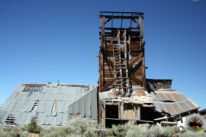
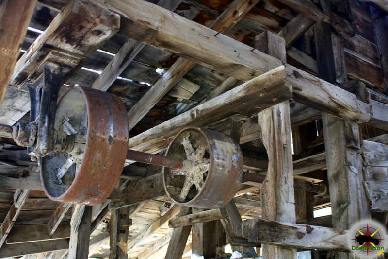
Located off the Masonic Road between Bridgeport, CA and the Masonic town site, are the remains of the Chemung gold mine. The Chemung gold mine operated from from 1909 to 1938 and produced over one million dollars in gold. In the 1920s, the Chemung mine was producing low grade and high grade ore. The ore was processed onsite, and then shipped to near by Bodie for smelting.

Along with the increase cost of mining supplies which reduced growth, a poor gold market and the cost of hauling the ore to Bodie over the poor roads for smelting and little mine was doomed and closed its doors in 1938.
The Chemung mine history is not a mining failure, but a failure of management and litigation. During its time of production, the mine built and tore down three mills. During the last year of operation in 1938, 20 men worked the site and less than one year later the mine was closed. The mine itself produced well, however endless litigation for various reasons doomed the mine.

Throughout the 1950s and 1960s new life was found in the mine with the efforts of Elton “Heinie” Heinemeyer. Heinemeyer mined for years but never struck it big. Well liked by the town of Bridgeport, CA Heinemeters well being was the source of concern for the people of Bridgeport and it is reported that he would always find time to visit and entertain those who traveled to check up on him.
Currently, the mill building structure is intact but the years of harsh weather have taken its toll. A mild wind will cause some of the walls to shake or shudder, and the lower outer wall is leaning outward. In June 2016, bars restricted access to the mines themselves although the mines do offer a cold breeze on a warm day to cool you down.
There are stories that the site is haunted by a spirit or ghost, but only on Saturday nights, which seems a bit odd to me.
On a personal note, the Chemung mine surprised me. I have been to Aurora three times, Masonic at least three times, and Bodie… at least ten. My last visit to Bodie was in 2013. Afterwards this last trip, I was looking in Google Earth when I “discovered” the Chemung gold mine. How had this mine, such an impressive structure, evaded my radar for so many years? It took me three years from that day to make my first visit to Chemung, and this place is definately on my list for a repeat visit.


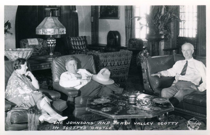
Named after Walter Scott AKA “Death Valley Scotty”, Scottys Castle or the Death Valley Ranch is located on some 1500 acres in Grapevine Canyon in Death Valley.
Built by Scott’s benefactor Albert Johnson in 1922, the Death Valley ranch cost between 1.5 – 2.5 million to construct at that time. The stock market crash of 1929 cost Johnson a considerable amount of money, and the ranch was never finished.
Scotty was a prospector, stunt rider and con man who used to con investors in to backing his “mining” adventures. It was reported that when the investor’s delegation wanted the view their new mine, Scotty would march them around the hot valley until they forgave or forgot about their investment.
On March 11, 1906 Scotty stared as himself in a play which opened in Seattle to a full house. We was arrested after his only performance and the charged for his crimes, the publicity exposed him to new investors. In spite of this Albert Johnson maintain interested in his “mine”. Another investigator was sent, who reported back that the mine did not exist. Johnson refused to believe this, and the following year he visited the mine himself, but left without seeing the mine. He was later sued by his investors in 1915 and ended up in jail.

In 1922, Johnson started building Scotty’s castle as a vacation home. When the size and scope of the property was realized, people assumed Scotty used the proceeds for his gold mine to pay for the Ranch. Scotty, ever the promoter did nothing to correct the record and soon The Johnson’ vacation home is associated with him
The Death Valley Ranch was know as “Scotty’s Castle in spite of the fact that Scotty rarely stayed over, rather living and sleeping at a 5 room cabin in lower vine canyon a short distance away

Due to its remote location, the Death Valley Ranch needed to maintain its own power station and water supply and evaporation cooling system. Despite the conditions, Scotty’s Castle boasts a 1,121 pipe theater organ, fountains, clock tower and a massive unfinished swimming pool.

There is no longer gas available at Scotty’s castle or grapevine canyon.
Scottys Castle was flooded in 2015 and not currently open to the public. The opening date has been pushed many times and currently scheduled for 2022. The flood was the result of over 3 inches in rain in just over 5 hours. The flash flood left debris in the visitors center over one foot deep and washed out the road.
| Name | Scotty’s Castle |
| Location | Death Valley National Park, California |
| National Register of Historic Places | 78000297 |
The story of the westward expansion is the story of the railroads. Beginning in 1862, the Union Pacific Railroad sought expansion opportunities along the western coast of the United States. To secure a foothold into California the railroads must cross the Mojave Desert and the depot in Kelso was crucial to accomplish this goal. Located at the junction of Kelbaker Road and the Kelso Cima Road, the Kelso Depot stands in testimony of the technological progress of the nations trains.

August of 1900, Montana Senator William A. Clark invested in a small Los Angeles based railway which would become the San Pedro, Los Angeles & Salt Lake Railroad. In 1902, in mine owner made a deal to sell half of the stock to the Union Pacific even before the railway was completed.

In 1905, after 235 miles of track are laid, three warehouse men placed their names in a hat and drew out the winner John Kelso, for whom track siding #16 of the Salt Lake route was named. Later in 1905, Kelso was just one depot along the Salt Lake Route which now stretched from San Pedro, CA to Salt Lake City Utah. This new route opened southern California to the Union Pacific Railroad. In 1921, Union Pacific convinced Senator Clark to sell his remaining shares.
Additionally, in 1905 Senator Clark divested himself of some land in southern Nevada along another rail stop. This auction is considered the birth of Las Vegas, and Clark Country was named for the man.

Built in 1921, The Kelso Depot is architecturally styled as a Mission Revival and just one of several depots along the route which were designated as division points and provided facilities for operations and maintenance purposes. The buildings original design included a telegraph office, conductor’s room, baggage room, staff dormitories, a billiard room, library and locker. The spring water in the nearby Providence mountains allowed the location to service the steam engines. Additionally, the relatively steep 2% 2000 foot grade necessitated the use of helper engines by the steam locomotives of the day to crest the Kessler Summit.
Union Pacific continued to operate the depot from 1921 to 1985. The depot provided much need infrastructure during World War 2, at which point the facility started a long decline in utility. Diesel engines improved efficiency and duration allowed the Union Pacific railroad to reduce their personnel requirements. The 1960’s introduced the second generation of more powerful and efficient diesel engines which eliminated the need for the helper engines. Combined with the cessation of passenger travel in August, 1964 the Kelso depot is destined to languish on the back roads of history. The Kelso Depot ceased operations as a train depot in 1962.
The Kelso Depot is currently in use as a Visitors Center of the Mojave National Preserve.

Doc Holliday, born John Henry Holliday, died on November 8, 1887, at the age of 36 in Glenwood Springs, Colorado. A dentist turned gambler and gunslinger, he suffered from tuberculosis for much of his life, which progressively worsened. By 1887, his health had deteriorated significantly, and he sought relief in the mineral springs of Glenwood Springs, hoping the warm waters might ease his condition. However, the disease, combined with his heavy drinking and frail state, led to his death in a sanatorium. Legend has it that his final words, upon looking at his bare feet and realizing he wasn’t dying in a gunfight, were, “This is funny.” He was buried in Linwood Cemetery overlooking Glenwood Springs.
News of Doc Holliday death was reported on November 10, 1887, by the Denver Republican.
Doc Holliday is dead. Few men have known better known to a certain class of sporting people and few men of his character had more friends or stronger champions. He represented a class of men who are fast disappearing the New West. He had the reputation of being a bunco-man, desperado and bad man generally. yet he was a very mild mannered man; was genial and companionable, and had many excellent qualities. In Arizona he was associated with the Wyatt Earp gang. These men were officers of the law, and were opposed to the ’‘rustlers” or cattle thieves. Holliday killed several men during his life in Arizona his body was full of wounds received in bloody encounters. His history was an interesting one. He was sometimes in the right, but quite often in the wrong, probably, in his various escapades.
The Doctor only had one deadly encounter in Colorado, and this was in Leadviile. He was well known in Denver and had lived here a good deal in the past few years. He had strong friends in some old-time detective officers and in certain representatives of the sporting element. He was a rather good looking man and his coolness and courage, his affable ways fund of interesting experiences, won him many admirers. He was a strong friend, a cool and determined enemy and a man of quite strong character. He has been well known to all the States and Territories west of Kentucky, which was his old home. His death took place at Glenwood Springs Tuesday morning.
Denver Republican.
Nestled within the stunning Escalante Petrified Forest State Park in southern Utah, Wide Hollow Campground beckons adventurers, families, and nature enthusiasts to an idyllic retreat where ancient geology meets serene waters. Perched at approximately 5,900 feet elevation along the shores of the 130-acre Wide Hollow Reservoir—just a short drive west of the charming town of Escalante off Scenic Byway 12—this campground offers a perfect base for exploring the dramatic landscapes of Grand Staircase-Escalante National Monument. Imagine awakening to the golden hues of sunrise reflecting off the reservoir’s clear blue waters, with the rugged silhouettes of distant canyons and the Kaiparowits Plateau framing your view. The area, part of Utah’s “Swell” region, is a geologic treasure trove shaped by millions of years of erosion, where slot canyons, natural arches, and expansive vistas create a playground for outdoor pursuits. Here, the air is crisp and invigorating, the nights starlit and quiet, and the days filled with the symphony of birdsong from raptors, songbirds, and waterfowl that frequent the shores.
Wide Hollow Campground is enveloped by the park’s signature attractions, blending aquatic serenity with terrestrial marvels. The reservoir itself is a highlight, stocked year-round with rainbow trout, largemouth bass, and bluegill, making it a prime spot for shore fishing or casting from a rented canoe, kayak, or paddleboard—rentals available on-site during warmer months (March to November). Its calm, swimmable waters invite lazy afternoons lounging on the sandy beach, while the adjacent petrified forest showcases nature’s artistry: colorful, mineralized logs in kaleidoscopic shades of red, orange, yellow, and purple, remnants of ancient trees fossilized over 150 million years ago. Easy-access hiking trails, like the 1-mile Petrified Forest Loop, wind through these formations, offering interpretive signs that reveal the area’s rich paleontological history amid blooming wildflowers in spring or golden cottonwoods in fall. Beyond the park, the broader Escalante region unfolds into endless adventures—hike slot canyons, horseback ride through desert washes, or stargaze in one of the darkest skies in the U.S. The elevation provides cooler summers and mild winters, though visitors should prepare for high-desert conditions with plenty of sun and minimal rainfall.
Designed for comfort without sacrificing the rustic charm of camping, Wide Hollow Campground features modern amenities to enhance your stay. The park offers 29 full-hookup sites across its loops (including the adjacent Lake View Campground), accommodating tents, RVs, and trailers up to 40 feet. Each site includes a shaded shelter, picnic table, fire pit with grate, paved parking, and ample space for privacy—many boast premium reservoir views toward Escalante’s iconic canyons and Powell Point. Electrical hookups range from 20 to 50 amps, with potable water and sewer connections at every site; additional frost-free water spigots are scattered throughout for convenience.
Supporting facilities keep things clean and convenient:
Reservations are recommended year-round via Utah State Parks’ online system, with fees starting at $16 per night for basic sites (including park entry). Pets are welcome on leashes, and the campground remains open all year, though services like rentals may vary seasonally. Whether you’re toasting marshmallows by the fire ring or embarking on a dawn paddle, Wide Hollow Campground delivers an unforgettable blend of comfort, recreation, and raw natural beauty—your ideal launchpad for Utah’s red-rock wonders.