
Big Bear, CA
I quiet mountain community full of back country adventure.
The Journey is the destination


Goblin Valley is located in Utah is a state park and campground which is adjacent to eroded flood plain. Formed by water, time and a soft sandstone, erosion sculpted the limestone into unique rock formations which some have stated appears to be goblins. The Goblin Valley itself is a day use hiking area which allows one to get lost in the maze of spires and rock formations.

Each rock spire ranges in height from 3 feet to about 20 feet tall. The fragile structures litter the landscape and sadly on occasion have been felled by people who do not have respect for nature. There are three established self, however the Valley of the Goblins is a open trail flat mud plane after a easy and short trail down from the parking area.
Goblin Valley State Park does offer an established campground of 22 campsites just over a hill from the Valley of the Goblins. The campground features, paved sites, bathrooms, showers, water and dump stations. The campground is very popular destination due to location next to Goblin Valley and is also a wonderful centralized base camp location for exploring the San Rafael Swell.

We stated in Goblin Valley in the off season several years ago. We were greeted with lots of camp sites available, privacy and a minor wind and rain storm. Despite the less then desirable conditions, we enjoyed our stay and will try to make it back again in the future.
Continue Reading →
Established in 1976, the Antelope Valley California Poppy Reserve is located just west of Mojave and boasts the most consistent blooms that the California Poppy. The reserve does not plant or water the flowers, so the timing and abundance of the flowers is solely dependent upon rainfall each year. The bloom season begins late winter and may last throughout the spring depending upon conditions. In addition to the poppy, the Reserve also hosts a variety of species including Owl’s Clover, Davy Gilia, Goldfields, Lupine and Cream Cups.
The 1745 acre flower reserve ranges in elevation frim 2600 to 3000 feet in elevations and boasts 7 miles of trails. There are limited facilities, but the reserve does have some wheel chair access.

The California Poppy ( Eschscholzia californica ) is a small perennial is typically a short flowering planet which boasts a vibrant orange bloom. The flower itself grows on top of a sledder stalk and the four petal flower which has a silky texture, appears extremely delicate and vulnerable to the elements. The flowers open each morning and close in the evening with the cooler air.

The California Poppy has a large range which included more of California, parts of Oregon, Washington, Nevada, Arizona and Northern Baja California.

North Rim Campground, perched on the remote and rustic North Rim of Grand Canyon National Park at an elevation of 8,200–8,300 feet, is a scenic haven for campers seeking solitude and stunning views. With 90 mixed-use campsites, including 78 for tents, trailers, and RVs (up to 40 feet) and 12 tent-only walk-in sites, it operates from May 15 to October 15, with reservations required via Recreation.gov. Located 210 miles from the bustling South Rim, North Rim Campground offers a quieter, less crowded alternative, nestled in a dense forest of ponderosa pines and aspens. Its proximity to the canyon’s edge and trails like the Transept and North Kaibab makes it a prime base for exploring the North Rim’s dramatic vistas. Below is a detailed review of its setting, amenities, accessibility, and overall experience, paired with a vivid description of the Grand Canyon.
The Grand Canyon, one of the Seven Natural Wonders of the World, is a colossal chasm carved by the Colorado River over millions of years, stretching 277 miles long, up to 18 miles wide, and over a mile deep. From the North Rim, at an elevation of 8,000–9,000 feet, the canyon reveals a distinct character compared to the South Rim. Its higher elevation and forested Kaibab Plateau setting create a greener, cooler landscape, with sweeping views of layered red, orange, and cream-colored rock formations that tell a geological story spanning nearly two billion years. The North Rim’s vistas, such as those from Bright Angel Point or Cape Royal, emphasize the canyon’s depth and vastness, with distant buttes and temples rising from the depths, often framed by lush meadows and aspen groves that turn golden in fall.
The canyon’s ecosystem teems with wildlife, including the endemic Kaibab squirrel, mule deer, and elusive mountain lions, while condors soar above the cliffs. The North Rim, receiving only 10–15% of the park’s visitors, offers a serene experience, with quieter trails and viewpoints that feel intimate despite the canyon’s immense scale. Sunrises and sunsets paint the rock layers in vibrant hues, and the night sky, unmarred by light pollution, is a stargazer’s paradise. The rugged terrain and remoteness demand respect, with monsoon thunderstorms (June–September) and early snows adding to the wild, untamed beauty.
North Rim Campground is located at the end of State Highway 67, 41 miles south of Jacob Lake, AZ, and 210 miles (4.5 hours) from Grand Canyon Village on the South Rim. Accessible via Highway 89A to Highway 67, it’s a remote destination with no direct road across the canyon. The campground is one mile north of the North Rim Visitor Center and Grand Canyon Lodge, connected by the scenic Transept Trail (1.2 miles). A free shuttle operates within the North Rim area, though most attractions, like Bright Angel Point, are within walking distance.
The campground features paved roads and parking spurs, but many sites are not level, with tight curves and narrow passages through trees, limiting larger RVs. Five sites (11, 14, 15, 16, 18) offer canyon views, while tent-only sites (T-1 to T-6) border the Transept Canyon rim. Three wheelchair-accessible sites are available, with nearby flush toilets and sinks, though the tent-only area has a vault toilet. The uneven terrain and walk-in tent sites (20–200 feet from parking) may pose challenges for those with mobility issues.
Each campsite includes a picnic table, fire ring with grill, and access to shared bear-proof food storage lockers (required for food and scented items). The campground offers drinking water, flush toilets, and sinks throughout, with a vault toilet in the tent-only section. Coin-operated showers and laundry are available near the general store, though they may close during water restrictions. A free dump station and potable water for RVs are located near the entrance. The general store, a short walk away, stocks groceries, camping supplies, and firewood, while the Grand Canyon Lodge offers dining options, including sit-down and grab-and-go meals. No electric, water, or sewer hook-ups are available at sites.
The campground is nestled in a thick ponderosa pine and aspen forest, providing ample shade but limited privacy due to closely spaced sites. Premium sites (11, 14, 15, 16, 18, 23, 24, 25, 26, 29, 31) offer filtered canyon views, while tent-only sites T-1 to T-6 border the Transept Canyon rim, providing scenic outlooks. “Site 18 was incredible—steps from the rim with a jaw-dropping view,” noted a camper (Tripadvisor, 2024). Sites are generally well-spaced, but some, like site 51, have layout issues, with trees obstructing pull-through access, requiring backing out (Campendium, 2024). The forested setting and quiet atmosphere enhance the experience, though noise from nearby campers can occasionally disrupt the peace.
The campground accommodates tents, RVs, and trailers up to 40 feet, though many sites are limited to 15–27 feet due to tight turns and trees. The maximum length includes both the RV/trailer and tow vehicle, and pop-outs or awnings may not fit at some sites. Tent-only sites require a short walk (20–200 feet) from the parking lot, accommodating up to six people per site. Three group sites (A, B, C) allow up to 25 people and three vehicles (max 12 feet). Generators are permitted during restricted hours (7–9 AM, 12–2 PM, 5–7 PM). Free parking is available, with overflow near the general store.
Reservations are required from May 15 to September 15, bookable up to six months in advance via Recreation.gov, with sites costing $18–$50 per night (group sites up to $55). From October 16 to October 31, sites are first-come, first-served, weather permitting. Demand is high, and sites often sell out quickly. “Book at 7 AM sharp six months out, or check for cancellations daily,” advised a camper (PerfectCamp, 2024). A backcountry permit ($10 plus $8 per person/equine per night) is required for winter camping (snowshoeing or skiing in). Arizona uses Mountain Standard Time year-round, except in the Navajo Nation.
North Rim Campground is a gateway to the North Rim’s serene trails and viewpoints. The Transept Trail (1.2 miles) connects the campground to the Grand Canyon Lodge and Bright Angel Point, offering rim-hugging views. The North Kaibab Trail, accessible via the Bridle Trail (0.8 miles), descends 14.2 miles to Phantom Ranch, requiring a backcountry permit for overnight hikes. Other trails, like the Uncle Jim and Widforss, offer scenic loops with canyon vistas. The Cape Royal Scenic Drive (25 miles) features stunning overlooks like Roosevelt Point. Mule rides, ranger-led programs, and stargazing events (including the June Star Party) are available. The nearby general store and lodge provide dining, a gift shop, and a visitor center with educational exhibits.
The Kaibab Plateau hosts unique wildlife, including the tassel-eared Kaibab squirrel, found nowhere else. Black bears, mule deer, and elk roam the area, requiring strict food storage in bear-proof lockers to prevent encounters. “Bears are rare, but squirrels and ravens will steal anything not locked up,” warned a camper (The Dyrt, 2023). Rangers enforce compliance with citations. Trash must be disposed of in bear-proof dumpsters, and recycling is available. The 8,200–8,300-foot elevation can cause altitude issues, and weather varies from warm summer days (60–80°F) to cold nights (30–50°F), with monsoon thunderstorms (June–September) and potential snow in May or October. Check forecasts and pack rain gear and warm layers.
North Rim Campground is a gem for those seeking a quieter, more intimate Grand Canyon experience. Its forested setting, rimside views, and access to trails like the Transept and North Kaibab make it a hiker’s paradise. The campground’s clean facilities, friendly staff, and proximity to the lodge enhance its appeal, though competitive reservations and occasional site layout issues are drawbacks. “The North Rim’s solitude and stunning vistas make this the best NPS campground I’ve stayed at,” summed up a camper (Tripadvisor, 2024). With early booking, careful site selection, and preparation for the remote location, North Rim Campground offers an unforgettable escape into the Grand Canyon’s majestic beauty.
Sources: Recreation.gov, NPS.gov, The Dyrt, Tripadvisor, Campendium, PerfectCamp, Hipcamp, GrandCanyonTrust.org, JamesKaiser.com
Racetrack valley is a rough graded road which departs the Ubehebe Crater site and heads south into the desert. The road is rough, but easily passable in a regular car. However, when entering back country areas such as this it is always a good idea to have the insurance of a reliable vehicle, high clearance, four wheel drive, etc… Do yourself a huge favor and air down your tires if you are properly equipped to air up when the trip is over.

The racetrack valley road is a 25 miles one way trip to the playa. The road is grated, but can be heavily wash-boarded depending on the time of year, rain fall, etc…
Along the way, there are many side trips and alternate trails to help expand your visit.
As you leave Ubehebe Crater, you will be driving south and gradually gaining elevation. Take your time and enjoy the drive, if you are lucky you may see a big horn sheep herd. The road gradually gains in elevation and climbs through a Joshua Tree Forest.
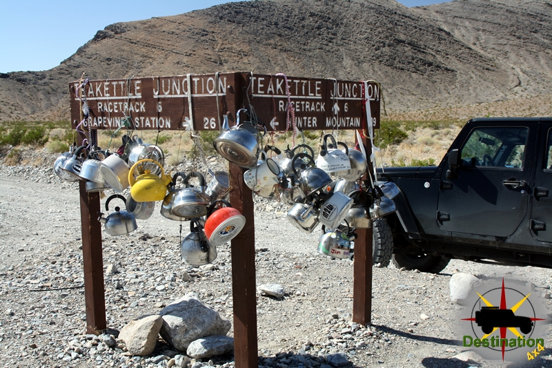
Once you reach the pass, the road continues to drop in elevation all the way down to the playa. Continue straight through tea kettle junction, and bear left down the valley past the side road to the Lippincott mine, which is a great side trail.

As you continue past the road to the Lippincott mine the road drops down to the Racetrack Playa itself. The first stop is ‘The Grandstand’ which is an outcropping of rock located in the north west corner of the racetrack. The second stop is the parking area to hike towards the stones. Don’t try to hike to the stones from the first Grandstand parking lot, or you will be hiking significantly further.
The highlight of the trip, is a short hike to the sailing or racing stones. The start of the hike is the parking area at the southern end of the racetrack playa.
To reach the stones hike east from the parking lot across the playa towards the dark stone hillside. It is short FLAT, meaning really FLAT hike towards the stones. Be sure the check the temperatures before you leave, and bring lots of water. This is true with anything you might want to do in Death Valley. Don’t walk on the playa if it is wet or muddy.

At the end of the 30 miles road there is a small primitive campground for overnight visits. Be sure to check with the National Park Service for regulations of back country camping within the park.

On September 19th, 1969 a Michigan front end loading is found burning along the road near the playa. Apparently, Manson order the machine burned. Park Rangers were deployed to the Racetrack. The rangers followed a set of tire tracked which belonged to a Toyota Land Cruiser which was stolen by Manson. The follow up investigate lead to the arrest of Charles Manson at Barker Ranch on October 12th, 1969.
The Standard Mill, also known as the Standard Consolidated Mining Company Mill, was a pivotal element in the history of Bodie, California. The building is one of the most iconic images or Bodie, and dominates the landscape. Located in the Bodie Hills east of the Sierra Nevada mountain range, this mill played a crucial role in the processing of ore from one of the richest gold-mining areas in the American West.

The Standard Company was founded in 1877, quickly becoming one of the most prominent and productive mines in the Bodie District. The company consolidated several claims, thereby gaining control over a large portion of the mineral-rich land. The successful extraction and processing of gold ore by the Standard Company were instrumental in Bodie’s transformation from a small camp into a bustling mining town.
The Standard Mill was constructed in 1877 to process the ore extracted from the company’s mines. It employed the latest technology of the time, using a combination of steam power, gravity, and chemical processes to extract gold from the ore. The mill utilized the amalgamation process, which involved crushing the ore to a fine powder and then using mercury to separate the gold. This process was later supplemented with cyanidation, which allowed for the extraction of gold from low-grade ore, significantly improving recovery rates.

Originally, as built, the mill is powered by large steam boilers. There boilers are fed using wood brought up to Bodie on the Bodie and Benton Railroad. The mill initially featured a 20-stamp system, but as operations expanded, it was upgraded to a 30-stamp system. Later, the mill is converted to Hydroelectric power from a plant built approximately thirteen miles from the town at Dynamo Pond.
Ore is loaded into the mill using one of two trestles. The primary trestle connects to the backside of the mill, and used to haul ore from the mines deep inside mines inside of the mountain. The secondary trestle is sloped to the north and is used to haul ore up sevens stories above the the loading room. From there, the ore is sorted with grizzly bars before being dropped into the powerful stamps.

The stamps, which were heavy iron rods, repeatedly crushed the ore into a fine powder. This powder was then passed over mercury-coated copper plates, where the gold particles would adhere to the mercury. The amalgam of gold and mercury was then collected and heated to separate the gold from the mercury.
The Standard Mill was the most significant factor in Bodie’s economic boom during the late 19th century. By 1879, Bodie’s population had swelled to approximately 10,000 people, with the Standard Company producing gold worth millions of dollars by today’s standards. The wealth generated by the mill attracted a diverse population, leading to the establishment of various businesses, schools, and a newspaper. During the height of operations, the stamps from the mill could be heard four miles away, and operated twenty-four hours per day, six days a week.


Despite its success, the Standard Mill faced numerous challenges, including harsh weather conditions, fires, and fluctuating gold prices. The mill experienced several fires, the most devastating occurring in 1898, which necessitated extensive rebuilding. Additionally, as the richest veins of ore were exhausted, the profitability of the mill declined. The Standard Company ceased operations in 1913, marking the end of Bodie’s major gold production.
Today, the Standard Mill stands as a testament to Bodie’s rich mining history. It is one of the best-preserved examples of a 19th-century mill in California. The site is now part of Bodie State Historic Park, established in 1962, which aims to preserve the town and educate the public about its historical significance. The mill’s machinery, structures, and surrounding buildings offer valuable insights into the technological advancements and industrial processes of the time.

Tours are available several times per day for a tickets price of $6 a person. The hour long takes you past the Hoover House up past the stream plant to the trestle, which fed ore up the the top of the mill. From there, the tour route enters the machinery room and power room before dropping into the slucing room and clean up rooms.
The Standard Mill was a cornerstone of the town’s mining industry and played a vital role in its economic development. Through its innovative use of technology and its contribution to gold production, the mill significantly influenced the growth and prosperity of Bodie during its peak years. Today, it remains an important historical site, providing a window into the challenges and achievements of the mining era in the American West.

