Lincoln County, located in southeastern Nevada, is a region defined by its vast desert landscapes, rich mineral resources, and a history shaped by Native American heritage, Mormon settlement, mining booms, and modern controversies. Established in 1866, the county spans 10,637 square miles, making it one of Nevada’s largest, yet it remains sparsely populated, with a 2020 population of 4,499. Its history reflects the broader narrative of Nevada’s frontier era, from indigenous stewardship to 19th-century mining and 20th-century military and extraterrestrial intrigue. This report provides a comprehensive overview of Lincoln County’s historical development, drawing on primary and secondary sources.

Prehistoric and Native American Era (Before 1800s)
Lincoln County’s human history begins with its indigenous inhabitants, primarily the Southern Paiute and Shoshone peoples, who lived in the region for thousands of years. Archaeological evidence, including petroglyphs and artifacts found in areas like the White River Narrows and Mount Irish, indicates occupation dating back to at least 3000 BCE. The Southern Paiute, known as the Nuwuvi, practiced a semi-nomadic lifestyle, utilizing the region’s springs, such as those in the Pahranagat Valley, for hunting, gathering, and seasonal agriculture. Their deep connection to the land persisted despite later Euro-American incursions, with descendants maintaining cultural ties to sites like the Kane Springs Wash Caldera, used for ceremonial purposes.
Early Exploration and Mormon Settlement (1820s–1860s)
European-American exploration of Lincoln County began in the 1820s with fur trappers and traders traversing the Great Basin. The Old Spanish Trail, a trade route connecting Santa Fe to California, passed through the region, notably along the Virgin and Muddy Rivers. By the 1840s, Mormon pioneers, under the direction of Brigham Young, began exploring southern Nevada for settlement opportunities. In 1855, Mormon missionaries established a mission at Las Vegas Springs, and by the 1860s, settlers moved into the Pahranagat Valley and Clover Valley. The town of Panaca, founded in 1864 by Mormon settlers led by Francis C. Lee, became one of Nevada’s oldest permanent communities. Initially part of Utah Territory, the area was incorporated into Nevada when the state was created in 1864.

County Formation and Early Development (1866–1880s)
Lincoln County was officially established on February 26, 1866, named in honor of President Abraham Lincoln. At its creation, it encompassed a vast portion of southeastern Nevada, including areas that later became Clark, Nye, and White Pine Counties. The county seat was initially set at Hiko, a small settlement in the Pahranagat Valley, reflecting the region’s early agricultural focus. The Mormon settlers in Panaca and surrounding areas developed irrigation systems to support farming and ranching, which remain economic staples today.
The discovery of silver in the Pahranagat Valley in 1865 sparked the county’s first mining boom. The Pahranagat Mining District attracted prospectors, and towns like Hiko and Logan Springs briefly flourished. However, the shallow ore deposits depleted quickly, and by the 1870s, attention shifted to other parts of the county. Pioche, founded in 1869 after silver discoveries at Mount Ely, emerged as the county’s economic hub. By 1871, Pioche’s rich silver veins, particularly from the Raymond & Ely Mine, produced millions, leading to a population of over 7,000 and the relocation of the county seat from Hiko to Pioche in 1871. Pioche gained notoriety as a lawless boomtown, with frequent gunfights and a reputation for violence; local lore claims 72 men were buried in the town’s cemetery before any died of natural causes.
Mining Boom and Bust (1880s–1910s)
The late 19th and early 20th centuries marked Lincoln County’s peak as a mining powerhouse. Pioche remained a major silver producer, with over $40 million extracted by 1930. The town’s infrastructure grew, including a narrow-gauge railroad connecting Pioche to the main line at Caliente by 1907, facilitating ore transport. However, the most significant mining activity occurred in Delamar, dubbed “The Widowmaker” due to the deadly silica dust produced during gold extraction. From 1895 to 1900, Delamar was Nevada’s leading gold producer, yielding approximately $13.5 million and supporting a population of over 3,000. The town’s prosperity was short-lived, as health hazards, a 1900 typhoid epidemic, and a fire led to its decline by 1909.
Other mining districts, such as Bristol, Tem Piute, and Eagle Valley, contributed to the county’s economy, producing silver, lead, copper, and tungsten. Caliente, established as a railroad and mining supply hub, grew steadily, while smaller towns like Alamo and Rachel emerged as agricultural and ranching centers. By the 1910s, many mining operations waned due to depleted ores, and Lincoln County’s population began to decline, with ghost towns like Delamar and Hiko becoming relics of the boom era.

20th Century: Ranching, Railroads, and Military Presence (1910s–1980s)
As mining declined, ranching and agriculture became Lincoln County’s economic backbone. The Pahranagat Valley, with its reliable springs, supported cattle and alfalfa production, while Panaca and Caliente remained community hubs. The railroad, particularly the San Pedro, Los Angeles, and Salt Lake Railroad (later Union Pacific), bolstered Caliente’s importance as a division point, with repair shops and a depot constructed in 1923. However, the railroad’s significance diminished after diesel locomotives reduced the need for servicing, and by the late 20th century, Caliente’s economy shifted toward tourism and services.
The 20th century also saw the federal government’s increasing presence in Lincoln County. In 1940, the U.S. established the Tonopah Bombing Range, part of which overlapped with Lincoln County. During the Cold War, this area expanded into the Nevada Test and Training Range, including Groom Lake, where the secretive Area 51 military base was developed in the 1950s. Area 51, located near Rachel, became a focal point for testing classified aircraft, such as the U-2 and SR-71, and later fueled UFO conspiracy theories, drawing global attention to the county.
Modern Era and Extraterrestrial Tourism (1980s–Present)
Since the 1980s, Lincoln County has embraced its association with Area 51 to boost tourism. In 1989, Bob Lazar’s claims of working on extraterrestrial technology at Area 51 sparked widespread interest, amplified by media and pop culture. The county capitalized on this by designating State Route 375 as the “Extraterrestrial Highway” in 1996, promoting attractions like the Little A’Le’Inn in Rachel and annual events like Alienstock. These efforts have drawn visitors worldwide, complementing the county’s historical tourism centered on ghost towns like Delamar and Pioche’s preserved 19th-century buildings.
Economically, Lincoln County remains reliant on ranching, small-scale mining, and government employment, with Nellis Air Force Base and federal land management agencies playing significant roles. The county’s population has stabilized at around 4,500, with Pioche, Caliente, Panaca, and Alamo as the primary communities. Recent decades have seen renewed mining exploration, particularly in the Delamar district, where companies like Integra Resources reported significant gold and silver resources in 2019.
Controversies have also shaped the modern era. Land use disputes, particularly over federal control of 98% of the county’s land, have fueled tensions, exemplified by the 2014 Bundy standoff in nearby Clark County, which resonated with Lincoln County ranchers. Additionally, environmental concerns, such as water rights in the Pahranagat Valley, remain ongoing issues.
Cultural and Historical Legacy
Lincoln County’s heritage is preserved through its historic sites and cultural traditions. Pioche’s Million Dollar Courthouse, built in 1872, and the Lincoln County Historical Museum showcase the county’s mining past. Panaca’s Mormon pioneer legacy endures, with its 1864 founding celebrated annually. The county’s ghost towns, including Delamar, Hiko, and Bristol, attract historians and adventurers, while archaeological sites like the White River Narrows are protected for their Native American significance.
The Southern Paiute continue to advocate for cultural preservation, with efforts to protect sacred sites and maintain traditional practices. Lincoln County’s blend of frontier history, military secrecy, and extraterrestrial lore creates a unique identity, making it a microcosm of Nevada’s diverse historical tapestry.
Conclusion
Lincoln County, Nevada, encapsulates the dynamic history of the American West. From its Native American roots and Mormon pioneer settlements to its mining booms and modern extraterrestrial tourism, the county has navigated cycles of prosperity and hardship. Its vast landscapes, dotted with ghost towns and military installations, tell a story of resilience and adaptation. As Lincoln County looks to the future, its rich heritage and strategic location ensure it will remain a significant, if understated, part of Nevada’s historical and cultural landscape.
Lincoln County Trail Map
Lincoln County Ghost Towns
 Bristol Nevada – Lincoln County Ghost TownBristol, Nevada, also known as National City, Bristol City, and briefly Tempest, is a ghost town located in Lincoln County, 14 miles northwest of Pioche,… |
 Bullionville Nevada – Lincoln County Ghost TownBullionville, Nevada, is a ghost town in Lincoln County, located approximately one-quarter mile east of U.S. Route 93, one mile north of Panaca, and ten… |
 Delamar Nevada – Lincoln County Ghost TownDelamar, Nevada, known as "The Widowmaker," is a ghost town in Lincoln County, located in the Delamar Valley approximately 30 miles southwest of Caliente. Its… |
 Fay Nevada – Lincoln County Ghost TownFay, Nevada, is a ghost town located in Lincoln County, approximately 10 miles northeast of Alamo. Once a small but active mining community, Fay has… |
 Hiko NevadaHiko, Nevada, is a small, agrarian community located in the Pahranagat Valley of Lincoln County, along State Route 318. Known for its brief but vibrant… |
 Jackrabbit Nevada – Lincoln County Ghost TownJackrabbit, Nevada, is a ghost town and former silver mining camp located in Lincoln County, on the eastern slopes of the Bristol Range. Originally named… |
 Logan City Nevada – Lincoln County Ghost TownLogan City, Nevada, also known as Logan, Logan Springs, or Logans Springs, is a ghost town located in the Mount Irish Range, approximately 9.5 miles… |
Lincoln County 4×4 Trails
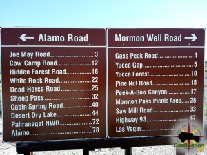 Alamo RoadAlamo Road and parts beyond. Photo by James L Rathbun The Alamo Road is the central route north through the Desert National Wildlife Refuge north… |
Logan City Nevada – Lincoln County Ghost TownLogan City, Nevada, also known as Logan, Logan Springs, or Logans Springs, is a ghost town located in the Mount Irish Range, approximately 9.5 miles… |
 Mormon Wells RoadEntering Peek-a-boo Canyon on the Mormon Wells Road. The Mormon Well Road is a long, rough, dirt road that runs across the Desert National Wildlife… |
Campgrounds
 Upper Lake CampgroundThe Upper Lake Campground is a free camp ground which features lakeside camping along the shore of Upper Lake Pahranagat, in Lincoln County, Nevada. Upper… |
Historic Markers
Bullionville Nevada – Lincoln County Ghost TownBullionville, Nevada, is a ghost town in Lincoln County, located approximately one-quarter mile east of U.S. Route 93, one mile north of Panaca, and ten… |
 Crystal SpringsCrystal Springs, Lincoln County, Nevada is an old watering stop, townsite and Nevada State Historic Marker number 205. The Nevada State Marker is location just… |
 Culverwells RanchCulverwells Ranch is Nevada State Historical Marker number fifty five located in Lincoln county, Nevada. The meadow area around the junction of Meadow Valley Wash… |
Delamar NSHM Nevada State Historic Marker #90Delamar NSHM is Nevada State Historical Marker number ninety seven and is located in Lincoln County, Nevada. Nicknamed "The Widowmaker", Delamar, Nevada is a ghost… |
Hiko NevadaHiko, Nevada, is a small, agrarian community located in the Pahranagat Valley of Lincoln County, along State Route 318. Known for its brief but vibrant… |
Jackrabbit Nevada – Lincoln County Ghost TownJackrabbit, Nevada, is a ghost town and former silver mining camp located in Lincoln County, on the eastern slopes of the Bristol Range. Originally named… |
Old Boundary (Nevada’s Southern Boundary 1861-1867)Old Boundary (Nevada's Southern Boundary 1861-1867) is Nevada State Historical Marker number fifty seven located in Lincoln county, Nevada. The marker is located about 6… |
 Pahranagat ValleyThe beautiful Pahranagat Valley is located in Lincoln County, Nevada and Nevada State Historic Marker number 38. Pahranagat Valley, nestled in the vast expanse of… |
 Pioche – Nevada State Historic Marker 5Pioche, Nevada is a silver mining town and Nevada State Historic Marker 5 located in Lincoln County, Nevada. Pioche was founded in 1864, during the… |