Ophir Nevada
Ophir Nevada is a ghost town and Nevada State Historical Marker number sixty four and is located in Lander County, Nevada.

In 1864, R. B. Canfield purchased the principal ledge, also known as the Murphy ledge. Canfield utilized the Twin River Mining Company to secure financing. A wagon road is constructed, in 1865, to the site from the Big Smokey Valley for a cost of $8,000 for the two and a half mile road. The steep route suffered from grades of 10 degrees and nine creek crossings are made with wooden bridges.
A Growing Town
The newly founded Toiyabe City has a population of 400 citizens and a tri-weekly stage from Austin brought in people and supplies for the mines. In 1886, a twenty stamp mill is constructed at great costs, from the natural granite and shale sourced in the area. The mill produced over $750,000 in silver in the next two years. Despite this seemingly high rate of production, the mines did not produce a profit, due to the unusually dense rock which slowed operations considerably.
During its heyday, Ophir Canyon boasted saloons, stores and hotels. A post office operated at the site from June 18, 1867 to December 5, 1893.
Nevada State Historical Markers identify significant places of interest in Nevada’s history. The Nevada State Legislature started the program in 1967 to bring the state’s heritage to the public’s attention with on-site markers. Budget cuts to the program caused the program to become dormant in 2009. Many of the markers are lost of damaged.
Nevada State Historic Marker Text
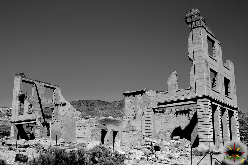
Well up into the canyon above, the massive stone foundations of a costly and splendid stamp mill as well as the stone walls of an elegant office and mansion are visible. This is the site of Ophir, now a ghost town.
In 1863, S. Boulerond discovered ore at Ophir. In 1864, the Murphy Mine opened and became the leading local producer. In 1865, a 20-stamp mill was completed costing over $200,000. This included the first experimental Stetefeldt furnace ever built. When the Murphy Mill was built, the town of Toiyabe City was established, growing to a population of 400. Through poor management, the work in the mines declined in 1869. Ophir was almost deserted. In the 1880s, the mines were reactivated, and Ophir had another period of prosperity. By the 1890s, the town was deserted but some mining activity at the Murphy Mine continued sporadically into the 20th century.
More than $3,000,000 worth of gold and silver were mined from the Murphy vein and from surrounding properties. Iron, copper and arsenic were also found in the area.
Ophir managed to have all the accouterments of a large community, including a school, a church, various lodges, and, of course, several saloons.
STATE HISTORICAL MARKER NO. 64
STATE HISTORIC PRESERVATION OFFICE
CENTRAL NEVADA REDEVELOPMENT ASSOCIATION
Nevada State Historic Marker Summary
| ID | 64 |
| Name | Ophir, Nevada |
| Location | Lander County, Nevada |
| Latitude, Longitude | 38.9385, -117.1971 |
Nevada State Historic Marker Map
References
Galena Nevada – Lander County Ghost Town
Galena Nevada was a silver mining from 1869 to 1907 and currently a ghost town located just just a west of highway 305 south of Battle Mountain, in Lander County, Nevada. The discovery of Silver at the head of Galena Canyon first lead miners in the area in 1863. Following the silver discovery three years later, in 1866, a mining camp forms to prospect the land.
In 1869, the townsite of Galena is plotted and originally located in Humboldt County. Daily stage service from nearby Battle Mountain delivered peoples and supplies to the small town. The town grew in size and citizens by the month. The town boasts a park plaza, water system, public hall, schools, and a post office is started in 1732.
Within the boundary of Humboldt County, the towns fortunes could have been secured, however it lost the battle for county seat to Winnemucca. A court house is planned within the town to seat this honor.
After 1875, the town of several hundred people began to succumb to reality as production slowed. In 1874, plans for the court house are abandoned when the Galena Range is ceded to Lander County. By 1886, the French Mining Company took over the mines and later halted development. After the post office closed, there was mining activity in Galena starting around World War I and sporadically into the 1960’s
Town Summary
| Name | Galena Nevada |
| Location | Lander County, Nevada |
| Latitude, Longitude | 40.564, -117.13 |
| GNIS | 854456 |
| Elevation | 1877 meters / 6158 feet |
| Population | Several Hundred |
| Post Office | June 2, 1871 – March 1873 [Humboldt Co.] March 1873 – May 27, 1887 [Lander Co.] As “Blanco” – October 11, 1888 – November 15, 1907 |
Galena Trail Map
References
Delamar NSHM Nevada State Historic Marker #90
Delamar NSHM is Nevada State Historical Marker number ninety seven and is located in Lincoln County, Nevada. Nicknamed “The Widowmaker”, Delamar, Nevada is a ghost town and gold mining town in Monkeywrench Wash, Lincoln County, Nevada. Prospectors and Farmers from Pahranagat, John Fergusen and Joseph Sharp officially discovered gold in 1889 around Monkeywrench Wash. This event lead to the founding of the Fergusen Mining District and a camp of that name was established. Initial assays ranged from $75 to $1000 per ton of gold ore. This was more than enough to attract the attention of investors.

Nevada State Historical Markers identify significant places of interest in Nevada’s history. The Nevada State Legislature started the program in 1967 to bring the state’s heritage to the public’s attention with on-site markers. Budget cuts to the program caused the program to become dormant in 2009. Many of the markers are lost of damaged.
Gold was discovered here in 1889. This isolated, treeless metropolis of over 1,500 residents, had a newspaper, hospital, school, churches, saloons and a stockbroker. Entertainment included brass bands, dance orchestras and stage attractions at the Opera House.
Water came from Meadow Valley Wash, 12 miles away. All other materials were hauled through the mountains by mule team 150 miles from a railroad head at Milford, Utah. For 16 years, most of the bullion was hauled out in the same manner.
The dry milling processes used prior to the introduction of wet methods created a fine silicon or “death” dust which caused the deaths of many residents and gave the town its nickname.
Delamar produced $15,000,000 in gold and was Nevada’s leading producer of that decade.
NEVADA HISTORIC MARKER #90
Delamar NSHM Map
Delamar NSHM Summary
| Nevada State Historic Marker | 90 |
| Name | Delamar “The Widow Maker”, Nevada |
| Location | Lincoln County, Nevada |
| Latitude, Longitude | 37.6207, -114.7839 |
References
Manhattan Nevada State Historic Marker #97
Manhattan Nevada is Nevada State Historical Marker number ninety seven and is located in Nye County, Nevada.
The town is originally founded in 1867 as part of a silver mining boom. The district abandoned in 1871. In 1905 a boom in gold mining activity brought over 4,000 people into the area. The Nye and Ormsby County Bank, the only stone structure to be built in the town, was erected in 1906. In 1906, the San Francisco earthquake literally shocked the region. The depression of 1907 tooked hold over investment capital and Manhattan faltered along with other gold mining towns including Rhyolite, Nevada.

The town on Manhattan saw a resurgance in 1909 and the population of 800 to 1000 people and their town matured into great little town. Local mines produced Gold, Silver and Copper, while Frank Garside published a weekly newspapper, the Post. The town continued its mining operations, including a gold dredge.
Nevada State Historical Markers identify significant places of interest in Nevada’s history. The Nevada State Legislature started the program in 1967 to bring the state’s heritage to the public’s attention with on-site markers. Budget cuts to the program caused the program to become dormant in 2009. Many of the markers are lost of damaged.
A Manhattan Mining District to the northeast was first organized in 1867, and some tunnel mining was done. The place name persisted in local use and was adopted in 1905 when John Humphrey found gold at the foot of “April Fool Hill,” near the old stage route. A typical boom followed. A post office was started late in 1905, and the camp soon had telegraph, telephone, utilities and businesses. Transport was to Tonopah and the railroad at Sodaville.
The 1906 San Francisco earthquake stopped mining investment. As a result, most of the productive work here was by lessees. The gold strikes were in ore and placer, and by 1909 there were 13 mines and 16 placers. Some of the operations were the Big Four, Litigation Hill Merger, Stray Dog, September Fraction and White Caps. Hydraulic placering started in 1909. In 1938, dredging began, continuing 13 years. Over $10,000,000 was produced.
“Manhattan always was a good camp.”
NEVADA STATE HISTORIC MARKER #97
Manhattan NSHM Map
Manhattan NSHM Summary
| Nevada State Historic Marker | 97 |
| Name | Manhattan, Nevada |
| Location | Nye County, Nevada |
| Latitude, Longitude | 38.5707, -117.1816 |
References
Candelaria and Metallic City NSHM Marker #92
Candelaria and Metallic City NSHM is Nevada State Historical Marker number ninety two and is located in Mineral County, Nevada.

Nevada State Historical Markers identify significant places of interest in Nevada’s history. The Nevada State Legislature started the program in 1967 to bring the state’s heritage to the public’s attention with on-site markers. Budget cuts to the program caused the program to become dormant in 2009. Many of the markers are lost of damaged.
Seven miles to the west lie the ghost towns of Candelaria and Metallic City.
Candelaria was presumably named after a mine of that name located in 1885, and also after the Catholic Candlemas Day. Metallic City, the “sin city” of Candelaria, and also known as Pickhandle Gulch, lies 3/4 mile to the south Candelaria. The name, pickhandle, was derived from the most popular weapon used for settling disputes.
In 1880, Candelaria was the largest town in the immediate area and boasted of having 3 doctors, 3 lawyers, 2 hotels, 6 stores and 10 saloons. Water piped from Trail Canyon in 1882 caused the price of water to drop from $1.00 to $0.05 per gallon.
The leading mine, the Northern Belle, was first located in 1864 (relocated in 1870). It is reported to have produced an estimated $7 million, mainly in silver.
NEVADA STATE HISTORIC MARKER #92
Nevada State Historic Marker Map
Ghost Town Summary
| ID | 92 |
| Name | Candelaria and Metallic City, Nevada |
| Location | Mineral County, Nevada |
| Latitude, Longitude | 38.2080, -118.0011 |


