
Big Bear, CA
I quiet mountain community full of back country adventure.
The Journey is the destination


My wife and I just got back from a camping trip in Death Valley National Park a few weeks ago. During this trip, for the first time we used a new “Family Sized” doom tent. The camping tents sleeps 6 people, is tall enough for me to stand up, came with a rain fly and outside vestibule. The new tent certainly had it all, which also caused me to think back to all the tents I have used and known.
The earliest and oldest tent I have used was a 1950’s era pup tent my father used in the Boy Scouts during the late 1950’s. The tent was nothing more than a piece of green canvas, two polls, wooden stakes and some string. The tent had no floors and no doors at either end. I used this tent once when I was about 9 years old, in my back yard. My dad helped me set it up in our backyard. From what I remember, it took about 10 hours to set. Most of this was watching my confused dad trying to remember how it was supposed to work. As I recall several of the wooden stakes split in the touch enriched soil of our backyard lawn. Once erected, and musty and the smell of mildew filled the air, but after a few hours it was aired out enough to crawl underneath. There was only enough room for my sleeping bag, and the tent was just tall enough that I could crawl underneath looking much like a WW2 G.I. going underneath the barbed wire.
That night, I slept under the “stars” in Los Angeles, CA. It was a mild fall evening as I recall, yet somehow my dads old pup tent managed to make it colder. Now having any doors meant that our cat could wander in during the night and scare me, which he did. I woke up early in the morning, went inside the house and finally got some sleep. I do not know whatever happened to this tent. It was better than nothing, but just barely.

During the late 70’s my family went camping a lot with my cousins. I don’t recall the true “owner” of tent, but the group had a family style tent. This thing was huge and seemed perfectly suited to host a sultan and his harem. Anyways, this thing was a beast and required a troop of 6 to move it into place. I know for a fact that when it was collapsed from the previous trip my mom and/or aunt would spend a hour sweeping out all the dust,dirt and grime brought in by four boys, It always confused me that each time we setup the tent again, we unfolded it to a cloud of dust and it was dirty inside.
These were great tents if weight was no object, but I suspect that these tents would not do well in a breeze yet alone a windy night. There was a complex exoskeleton of polls which could never be assembled unless you had a masters in engineering. There was one large door, and a floor, which is a much needed feature over my dads pup tent. I don’t remember any windows, but I do recall that unlike my dads pup tent which “cooled the air”, this tent always ran HOT.
Prior to a spot horse packing trip in the early 1980’s. Dome tents had yet to come into their own. My folks purchased two pup tents for the trip. The modern version of the pup tent was constructed with rip stop nylon and did include a floor, short side walls, a closed off back along with a door and screen door. The tent did not include any sort of rain fly, so my folks made one witch attach using a three inch standoff my dad built on his lathe. This proved very important as during the trip we were deluged with rain.
Dome tents have dominated the market since they were introduced to the market. They range in size from small two man models to large family sized. They may contain multiple rooms, vestibules and some have a small door to access an ice chest to gain access to a much needed beverage. All in all they are the best of the best, strong, flexible and lightweight.

Many years ago I was camping with a boy scouts at the annual desert caravan, which was a large camp out with scouts from around southern CA. There were probably 800 campers there that weekend. The previous year high winds buffeted our campsite, and learning from the previous year I came prepared. During the day I erected my dome tent which was about six feet tall. Knowing the winds were coming, I ran a guy wire from each of the polls out 50 feet. Whenever possible, I would tie it down to a sage bush. So, I effectively had my tent anchored to the earth in a 50 foot radius all around. A few of my friends made fun of me for my setup.
And then the winds came….
Throughout the night, the winds howled. It was far, far worse than any previous year. It was difficult to sleep with the sound of the wind buffeting the tent. After a long and sleepless night, I emerged from my tent to discover the damage done by the winds that night. It wipe out the camp, the entire dessert caravan. Outhouses were lifted and thrown 100 feet, and broke car windshields. Worst of all, every tent was broken, torn and shattered by the wind. Tent poles were split, bowed and broken. Every tent was wiped out…. except mine.
In the days of tablet computers and smart phones, it is trendy to rely on the latest technology rather than maps and communications. There is nothing wrong with that, however, it is still important to maintain a backup plan. For example, any device that relies on cell phone tower will be virtually useless in the back country.
There are methods with image caching, that you can utilize these types of devices when the cell signal is unavailable, which is great. But if you plan for the eventuality that at some point that device will fail, or the batteries die or you visit Death Valley, you will be significantly better off carrying maps and communications radio gear with you.
The best backup plan is a quality map of the area you are going to be in. Part of any good trip into a new area involvces planning, what better way to plan a trip, is to lookup the area and learn more about it. There are a variety of websites which offer topomaps, such as mytopo.com not to mention that you can order high quality Topograph maps online. Maps such as these offer a valuable look into the area, and provide a level of detail not found on most tablets or GPS units.
It is always a good idea to carry a compass. A compass makes it easier to use the maps you have, or with general familiarity of the area area valuable tool to get unlost. Should you be willing to drop $400 on an iPhone or the latest tablet, spend another $4 and have a backup, which is probably more useful.

Family Radio, CB and HAM radios are huge assets in the back country. Locations such as Death Valley’s Racetrack valley don’t even try to offer cell service. Turning a cell phone on in locations like this, will just drain your battery turning your phone into a poor paper weight.
Family Radio (FRS) – Family Radio is very popular, and the radios can be purchase in pairs from almost any large department store for about $50. The radios are small, cheap and light weight and has no licensing requirements. They are limited to short little antannes and .5 watts of power. As a result, the range is limited, but work well in open areas over short distances.
Citizens Band (CB) – Citizens Band or CB radio is probably the standard communication system with many backraoding groups. Frequently, clubs will require a CD radio in order to join. The Radios can be purchased online or from some electonics stores, starting at $75. There is no regulartory limit on the antannae systems, unlike the FRS. In the United States, the Radios are limited to 4 Watts for AM service. There is no license requirement for CB Radio
Amatuer or HAM Radio – If you really what to reach out and touch someone, then Ham Radio is the way to go. However you are required to get a license and pass a test to operate these radios. Ham Radio’s may be purchased online or from a local electronics store. Mobile UHF/VHF units start at about $180 and can come with up to 75 Watts of power. Additionally the use of repeaters allow the HAM operator to bounce their radio signal thousands of miles.
Additionally licenses for HAM Radio opens up the HF bands. Mobile HF radios tend to start at $500 for the radio, and the car may need to be modified to operated the radio correctly. One of the many benefits of HF Radio is the ability to communicated beyond the horizon without the need for a repeater. Maps and communication gear is important, if you know how to use it.
For those interested in getting a HAM radio license, the practices tests can be found at: https://hamexam.org/exam/12-Technician.
After our recent trip to the center section of the Old Mojave Road, my wife Heather was really excited to run the western section and complete the entire length of the trail. Her idea was to drive the western section on our way to our annual trip to Big Bear, CA over the Memorial Day holiday. I worried that such a trip during this time of year could be a rough trip due to high temperatures in the desert. In late April we finished the center section in Baker, CA and the air temperature was only 107 degrees. Despite my concerns, we gladly planned our trip and embraced her good idea.

As we prepared for our trip, gathered our gear, food, and checked out the mechanics of the jeep, I decide to check the local weather report. To my surprise, weather.com predicted the temps in the mid 80s with clear sky’s and light wind. The weather could not be any better.
Another interesting development, is that Heather kept offering to drive in the event I got tired of driving. She didn’t just offer once, but several times per day for several days before our departure. Being the good husband that I am, after about twenty or thirty offers, I started to get the idea that, subconsciously, Heather might want to drive this run. So after some arm twisting and bartering, I finally convinced her and Heather agreed to take the wheel. This of course, would be a great source of confusion for me during the trip, however I am certain I can persevere this new dynamic. This is not to imply that Heather is not one of the finest drivers I know, far from it.
An old trail leads off through the lava and into the great unknown.
All packed up, we left the Las Vegas area at 7:00 am on Saturday morning, and headed towards Baker. A quick stop in Baker, we topped off the fuel tank and took our respective bathroom breaks. Once Heather reminded me that she was driving this trip, I took my seat on the right had side of the jeep and we headed down Kelbaker Road.
It took me a few miles, but soon I became used to having my coffee cup on the wrong side, no pedals, eta… This must be what it is like in England. The map and guide-book took some getting used to as well, but somehow I managed to get us to the trail head. It certainly didn’t hurt that we were here just a few weeks before. A quick turn on to the trail, and we stopped to air down the tires for some ride comfort.
After dreaming of this trip for the past few weeks we are finally on our way. We followed the trail around 17 mile point and then turned southwest into the Mojave. The road steadily looses elevation as it cross a fallout zone of lava and start to head down into the valley.
After our recent trip to the center section of the Old Mojave Road, my wife Heather was really excited to run the western section and complete the entire length of the trail. Her idea was to drive the western section on our way to our annual trip to Big Bear, CA over the Memorial Day holiday. I worried that such a trip during this time of year could be a rough trip due to high temperatures in the desert. In late April we finished the center section in Baker, CA and the air temperature was only 107 degrees. Despite my concerns, we gladly planned our trip and embraced her good idea.
As we prepared for our trip, gathered our gear, food, and checked out the mechanics of the jeep, I decide to check the local weather report. To my surprise, weather.com predicted the temps in the mid 80s with clear sky’s and light wind. The weather could not be any better.

Another interesting development, is that Heather kept offering to drive in the event I got tired of driving. She didn’t just offer once, but several times per day for several days before our departure. Being the good husband that I am, after about twenty or thirty offers, I started to get the idea that, subconsciously, Heather might want to drive this run. So after some arm twisting and bartering, I finally convinced her and Heather agreed to take the wheel. This of course, would be a great source of confusion for me during the trip, however I am certain I can persevere this new dynamic. This is not to imply that Heather is not one of the finest drivers I know, far from it.
All packed up, we left the Las Vegas area at 7:00 am on Saturday morning, and headed towards Baker. A quick stop in Baker, we topped off the fuel tank and took our respective bathroom breaks. Once Heather reminded me that she was driving this trip, I took my seat on the right had side of the jeep and we headed down Kelbaker Road. It took me a few miles, but soon I became used to having my coffee cup on the wrong side, no pedals, eta… This must be what it is like in England. The map and guide-book took some getting used to as well, but somehow I managed to get us to the trail head. It certainly didn’t hurt that we were here just a few weeks before. A quick turn on to the trail, and we stopped to air down the tires for some ride comfort.
After dreaming of this trip for the past few weeks we are finally on our way. We followed the trail around 17 mile point and then turned southwest into the Mojave. The road steadily looses elevation as it cross a fallout zone of lava and start to head down into the valley.
After a few more miles, we “discovered” the Little Cow Hole Mountain Mill Site just north of the road. The short drive over to the site was well worth it and provided you are at all interested in locations such as these. There is a large concrete foundation which appears to be the footings for the mill itself, along with several retaining walls. There is a very minor uphill section of to the foundation level of the mill. Heather did a great job on this minor obstruction. I am still amazed that she easy handled the slope despite my exaggerated gesturing and attempts to apply the brake or depress the gas from the passenger seat.

The next stage of the Old Mojave Road, drops the remaining elevation down to the Soda Dry Lake. For those who drive the I-15 highway between Barstow and Primm, this is the large desolate dry lake bed just off the highway as you drop into Baker from the South. The Soda Dry Lake is a flat expanse, that when dry is easily passable. However, judging from the troughs through the dried mud, it seems to be very rough terrain to traverse unless you have significantly more horsepower and larger tires. Most definitely bad form in my opinion and I certainly would never put my Jeep to this test.
Driving across the soda lake is an awesome experience. Either you appreciate terrain such as this, or you don’t. The flat dry desolation along with the white color of the soda lake combines perfectly with the crunch below your feet and the wind blowing. Oddly enough, the higher the temperature and wind speed, the more I appreciate this environment. There is a tranquility in this place and really gives on the feeling that you are alone and out in the middle of no where.

We did make the prerequisite stop at the “Travelers” monument. My son Ryan added to the pile and we let Ryan and our Labrador Retriever, Rooger AKA the boys, run around and stretch their legs. The boys played while I explored the area photographically.
Again we loaded up the boys and continued our travels. Once we left the dry lake, we found ourselves in a deep sandy road after a quick right and then left turns at the “Granites” rock formation. There was no danger of getting stuck in the sand for us, but Heather was naturally concerned. She gained experience and confidence as we crossed over Shaw Pass and followed the rocky road down the backside. This was soon shattered when a high-pitched voice from the back seat sang out, “Mom, can you let dad drive?”
Once we crossed the rather nondescript pass, we dropped into the Mojave River Wash. This section of the trail is just sandy river bed and marked with either Cairns or railroad ties. During the Mojave River wash section, both Heather and I had to really keep an eye open for the markers. In many locations I noticed several parallel trails and multiple markers. For the most part you just travel in a western direction and keep to the left side of Cave Mountain.
Sandy conditions aside, this section of the trip was a lot of fun. There are an abundance of birds, and we jumped several large jack rabbits. As the terrain is sandy and with intermittent bushes, when we did see a rabbit, it was easy to follow them when they ran into the distance. Although we are in middle of the Mojave desert, an extremely harsh and arid place you would not know that considering the size and number of these rabbits.
Towards the end of the Mojave River Wash at the intersection with Basin Road, there is a large mining complex. We stopped for lunch and a hike. ’The boys’ were very exciting to hike an old track line which had rail road ties embedded into the rocky soil. One a future trip we will have to return and explore this area further as there are trails and roads all over this site. I don’t know much of the history of this spot, what was mined, etc… but this is a very interesting place and will be the subject of future adventures.
Back on the trail we headed towards and under the infamous railroad bridge. The bridge itself glistened in the sun and shined like a beacon in the distance. The bridge moaned as a train crossed over head on its way to drop off its cargo. I got out of the car to take some photos of the jeep and the bridge. Thankfully, Heather in an act of kindness did turn around and picked me up.
We continued to follow the river bed down and through Afton canyon. Afton Canyon is a gem of the Mojave desert. On the trail, we found a buried rail road car and soon crossed paths with the only other traffic on this forty mile side trip.
The rail road car is a great example of why the Mojave desert is such a wonderful place. Scattered across the landscape is the history of this country. Old rail cars, mines, camps, watering holes and even crashed jet airplanes can still be found lying around. You just need to learn to look.
Afton Canyon is just an amazing spot and the trail follows the riverbed through the water and wind-swept canyon. The colors and geology are amazing and photographically offer a lot of opportunities. A fence clocks the trail from following the river further for environmental rehabilitation purposes and the trail jumps up next to the train tracks for a while.
After two short water crossings this section of the Old Mojave Road dumps out into the Afton Canyon Campground. Once again Heather’s jeep confidence grew as I asked her to back up into the water crossing again to take some photographs of some cat tails growing in the river. The Afton Canyon Campground isn’t much to look at, and personally I would rather camp in the back country.
Once past the campground, we drove up the road towards the I-15. A quick stop to add some air pressure back into the tires and make us safe for high-speed travel. Once we aired up, Heather announced that she was tired and decided that I should drive. A bit over an hour later, we arrived at the house in Big Bear and unpacked. Following a quick dinner, the boys quickly crashed out.
This was the first time the Heather did significant driving on the back roads. She did a great job, and I am thrilled that she is taking to our trips with such a wonderful attitude and sense of adventure. This weekend, she drove 75 of the 110 miles of back road driving. I am very proud of her.
Back country ethics came to the forefront recently. Over the last weekend, my wife and I decided to take a camping trip into the back country of Death Valley National Park. We were inspired to return to Racetrack Valley, and over night at the Homestake Dry campground. Upon our return, we were greeted with the grim news that another hiker had died in Zion National Park. Zion is a personal favorite location and I know it well, and every time someone has an accident in the area I can’t help of think of the small little details that allow these tragedy’s to occur. I would later recall that an actor died in Death Valley National Park this year. There is, in fact, a book series written by Michael P. Ghiglieri that emphasizes death in various National Parks and the locations of each, are places which I frequent.

To be sure, although stories like these grab attention and headlines I am sure that they are overblown in their publicity and for the most park the National Parks are safe. The drama in each example is that we all visit there locations and with rare exception we all return with photo graphs and memories to last a life. Many of this accidents are preventable, with the understanding the hindsight is always clear, I still can’t help but wonder what would happen should I ever find myself in a one of these situation?
Prior to any trip, I check and double checked my gear list. The list changes depending upon time of year, destination, etc… but known the less I try to anticipate potential issues while I am loading the jeep. The jeep is always packed with a first add kit, tools, 2 meter ham and CB radio, area maps, cell phone, extra water, fuel and food. This is standard operating procedure for us.
During our weekend in Racetrack Valley we ran into a total of four other vehicles over the course of 24 hours. Of these autos, two were in need of some assistance and I was more than happy to provide help. The first car was a new Jeep Grand Cherokee which appeared to be just off the lot. The Grand Cherokee is a great car, and they just had a flat tire. The racetrack playa road claims many tires each year, and the owner was able to get the tire changed in just a few minutes. The flat tire was a minor issue and they were soon on their way, although there had to be careful because they did not have a true spare tire but rather one of those light weight little donuts tires.
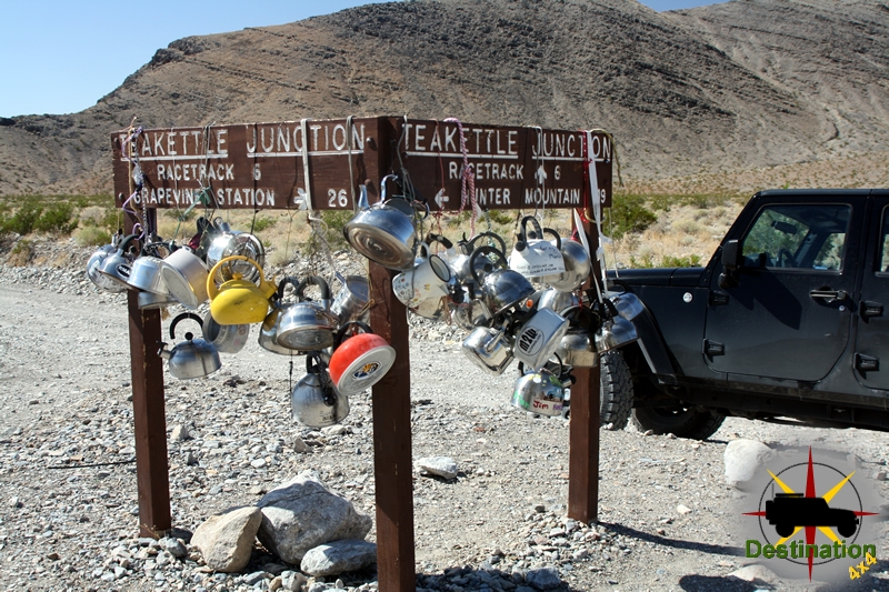
After an overnight stay at the Homestake dry camp, we left for our day full of explorations. After a brief stop at the Lippincott Mine we headed north towards Teakettle Junction. Upon arrival, our plan was to head east towards Hunter Mountain, however before we could make the turn the driver of a parked white Infinity coupe flagged us down requesting help. So, I stopped the jeep, got out and walked towards the Infinity. Our of the car, a woman in her 20’s or early 30’s stepped out of the car. She was dressed like she was going to a summer bar-be-queue, complete with perfume, tight shorts, stylish shoes and make up in place. So, seventeen miles in the back country of Death Valley National park, she pulled out a cheap gas station map and asked for directions.

I took a minute for me to completely comprehend what was being asked of me. So, she starts out, pointing to Teakettle Junction of the map and asks if she was in fact “there”. I told her “Yes, this is Teakettle Junction” which is funny to me since Teakettle Junction has a huge sign which reads “Teakettle Junction”, which is turn, is covered with about 50 Teakettles. To which she points in the area of Saline Valley and tells me she is meeting her friends and wanted to know if she should take “this road” and points to the Lippincott Mine Road. For those how are not aware, the Lippincott Mine Road is a non-maintained steep 4×4 trail with a sheer cliff on one side. This is not the sort of thing you should try in an Infinity coupe with no low range and street tires and I told her politely that she is foolish for thinking of it. She responded, “yeah, my friend told me that.”
To summarize now, I ran into someone, clearly not prepared for her environment, who did not listen to the advice of her friend, and is now asking for directions, 17 miles down a wash-boarded road, from a complete stranger. I suggest that she turn around, head back to the highway, and jump on the pavement and take the long way around. To which, she asked about “this road” and she points to the “Hunter Mountain Road”. I told her that I didn’t know about the condition of “that road”, and my guess is that the road was more of the same of what she had already done, but “I hasten to add, I am not sure.” She thanked me, and just as I left I told her to “turn around”. I jumped back in the Jeep and went on to my next destination, the Lost Burro Mine.
After some time at Lost Burro, lunch and some further exploration a front arrived in the area and rain began to fall. We made our may make down to the Hunter Mountain Road. Prior to ending our trip, I want to run down to some other mines as the rain fell harder. At which point, I noticed that we were following fresh street tire tracks on the road. The car in front of us lost traction as it struggle to climb out of a sandy 6 inch gully which would not been an issue for any small SUV, but a different story from an Infinity car. Each turn we were surprised not to find this woman, stuck by the side of the road with a flat tire or something else. Mile after mile we followed the tracks until we reached our final destination at the Quakenbush Mine, at this point the turned around and ended our trip.
On the drive home, my lovely wife Heather and I discussed her situation. We both agree that she was stupid for putty herself in danger. She did not listen to her friend. She did not appear prepared for anything, yet alone the back country of Death Valley. I potentially saved her life that day, but I can’t help but wonder if I should have been more firm or blunt in getting her to turn around. But then again, would it have mattered? She already ignored her friends advice.
Where does my obligation to help end? Or does it ever end? Of coarse, if our paths crossed deep in the Hunter Mountain Road we would completely helped her out and ensure her safety. However, if you have an dealing with an adult, presumably of sound mind, when is enough help, enough? She wasn’t in danger sitting at Teakettle Junction. She is probably made her destination and is probably safe and sound. She probably still does not realize the potential danger of her situation that day. I believe I talked her out of the Lippincott Mine Road “shortcut”, but I don’t know. Perhaps, a series of small seemingly unimportant events was already cascading to push her towards her destiny which can only be seen with hindsight. Perhaps, I interrupted the series of unfortunate events and removed a chapter from Mr. Ghiglieri’s next book