Eureka Dunes Dry Camp

Death Valley National Park Campground

Eureka Dunes Campground (Primitive) is a remote, no-frills outpost at the base of California’s tallest sand dunes in the far northwestern corner of Death Valley National Park. It delivers solitude, dramatic scenery, and exceptional dark skies for those willing to drive rough roads and fully self-sufficient.

Geographic Description

The campground sits at about 2,880 feet elevation in Eureka Valley, an isolated enclosed basin northwest of the main Death Valley floor. The Eureka Dunes themselves rise more than 680 feet above the dry lakebed—among the tallest in California and possibly North America—spanning roughly 3 miles long by 1 mile wide. They form a pale mountain of sand against the rugged, color-banded limestone walls of the Last Chance Mountains, which tower another 4,000 feet above the valley. The setting feels otherworldly: golden, wind-sculpted dunes framed by stark desert mountains under vast, empty skies. The area is a true “island in the desert,” home to endemic plants found nowhere else (including the endangered Eureka dunegrass, Eureka evening primrose, and shining milkvetch). Under the right dry conditions the dunes can “sing,” producing a deep bass-like or organ-pipe hum as sand avalanches.

Access requires high-clearance vehicles (4WD recommended, especially after weather). From the park’s Scotty’s Castle Road / Ubehebe area it’s a long graded dirt route; from Big Pine on US 395 it’s roughly 28 miles paved then 21+ miles dirt, with the final ~10 miles on South Eureka Valley Road often washboarded, rutted, and sandy. RVs and trailers are generally not advised.

Amenities

This is a true primitive campground with seven first-come, first-served sites (no reservations, no camping fee beyond the park entrance fee).

  • Concrete picnic tables and metal fire rings at each site
  • Vault/pit toilet (condition varies; sometimes poorly maintained)
  • Sites are spaced for relative privacy

What you will not find: water, electricity, showers, trash service, dump station, or cell service. Pack in all water and supplies and pack out all trash. Fires are allowed only in the provided rings; propane stoves are fine. Pets are generally allowed but keep them leashed and off the sensitive dunes. Sandboarding and driving on the dunes are prohibited to protect the fragile endemic species.

Best Times to Visit

Open year-round, but summer (roughly June–August) is strongly discouraged—daytime temperatures frequently exceed 100°F and the exposed valley offers little shade or relief.

Ideal seasons are spring (March–May) and fall (September–November), when daytime highs are typically in the 60s–80s°F and nights are cool and clear—perfect for hiking the dunes and stargazing. Winter can be excellent for solitude and dark skies (nights get cold; bring warm gear), though roads may be affected by weather. Weekdays are quieter than weekends. Always check current road conditions and weather with the park (760-786-3200) before committing to the long dirt drive.

Nearby Points of Interest

  • Eureka Dunes themselves — The main attraction. Hiking to the summit is a strenuous but rewarding slog (steep loose sand; ~3 miles round-trip with significant elevation gain). Early morning or late afternoon light is spectacular; the “singing” phenomenon is a rare bonus when conditions are right.
  • Ubehebe Crater — A large volcanic maar crater (and smaller Little Hebe) reachable via the approach roads; rim walks and views of colorful layered walls.
  • Scotty’s Castle area — Historic (flood-damaged and long closed to full tours, but the vicinity remains part of the northern park experience).
  • Further afield within the park: the Racetrack Playa (famous sliding rocks, longer rough road), Mesquite Flat Dunes, and classic Death Valley highlights such as Badwater Basin or Artist’s Palette if continuing south.

Overall verdict: Eureka Dunes Campground ranks among Death Valley’s most memorable remote experiences for self-reliant campers who prize solitude, night skies, and unique geology over comfort. The payoff—waking up at the foot of towering golden dunes with almost no one else around—is outstanding. Come prepared, tread lightly on the fragile ecosystem, and the isolation becomes the highlight rather than a drawback.

Campground Summary

Campground NameEureka Dunes Dry Camp
LocationDeath Valley National Park, California
Latitude, Longitude37.111773, -117.680898
Elevation2890
Number of Sites4
AmenitiesRestrooms, tables

Eureka Dunes Campground Map

References

Thorndike Campground

Death Valley National Park Campground

Thorndike Campground is a small, free, first-come, first-served primitive campground in Death Valley National Park’s Panamint Mountains. It offers a quiet, forested high-elevation escape from the extreme heat of the valley floor.

Geographic Description

Thorndike sits at about 7,400 feet (2,250 m) elevation among pinyon pine and juniper trees. This creates a cooler, shadier, more alpine feel than the typical Death Valley landscape far below. The surrounding terrain is rugged and mountainous, with sandy sites in places and views into the surrounding peaks and canyons. Temperatures here are often 20–30°F cooler than the valley floor, making it a genuine refuge during warmer months.

Access requires a high-clearance vehicle (maximum recommended length ~25 feet); 4WD is often needed, especially on the final stretch of rough dirt road beyond the Charcoal Kilns. The campground is remote—roughly 50–60+ miles and 1.5–2 hours from Furnace Creek or Stovepipe Wells depending on the route.

Amenities

This is true primitive camping with minimal facilities:

  • 6 sites (tent or small high-clearance vehicles/RVs)
  • Picnic tables and fire rings/grates at sites
  • Seasonal vault toilets (often noted as surprisingly clean)
  • Seasonal trash collection
  • No potable water, showers, electricity, dump station, cell service, Wi-Fi, camp store, or firewood for sale

You must bring all water (nearest sources are many miles away—Emigrant area or Stovepipe Wells) and your own firewood (gathering is prohibited). Wood fires are allowed only in provided NPS pits and are banned during high fire danger periods (typically mid-June to mid-September). Quiet hours are 10 pm–7 am; max 8 people and limited vehicles per site; 30-day stay limit.

Best Times to Visit

The campground is typically open mid-April through December, weather and snow permitting. It can remain snowy or icy into late spring, and winter access is often impossible or closed.

  • Best overall: Late spring through fall (especially May–October/early November). Daytime temperatures are comfortable (often 60s–80s°F), nights are cool to cold, and the elevation provides a welcome break from valley heat.
  • Summer is viable here when lower elevations are dangerously hot.
  • Avoid or carefully check conditions in winter/early spring due to snow, ice, and road closures.
  • Arrive early on weekends or holidays—there are only six sites and no reservations.

Always check current road and weather conditions with the National Park Service before going, as high-elevation conditions change quickly.

Nearby Points of Interest

Thorndike makes an excellent base for high-country exploration:

  • Wildrose Charcoal Kilns — Just down the road (a short drive or walk). These well-preserved 1870s beehive-shaped stone kilns are among the best surviving examples in the West and offer easy exploration plus trailheads.
  • Mahogany Flat Campground — A few miles farther up the road at ~8,200 ft; more sites and the primary trailhead for Telescope Peak.
  • Telescope Peak (11,049 ft) — The highest point in Death Valley National Park. The strenuous ~14-mile round-trip hike (with ~3,000 ft gain) starts at Mahogany Flat and delivers spectacular views of Death Valley, the Sierra Nevada, and surrounding ranges. Thorndike works well as a lower staging camp if Mahogany Flat is full or the final road section is too rough.
  • Wildrose Peak trail (from near the kilns)
  • Broader Panamint Range hiking, stargazing (excellent dark skies), and wildlife viewing

Overall impression: Thorndike is ideal for self-sufficient campers seeking solitude, cooler temperatures, and a forested mountain setting within Death Valley. It is not for those needing amenities, large RVs, or easy access. The combination of free camping, shade from pinyon and juniper, and proximity to the Charcoal Kilns and Telescope Peak trail makes it a standout high-elevation option when conditions allow. Pack thoroughly, drive carefully, and enjoy the quiet.

Campground Summary

NameThorndike Campground
LocationPanamint Mountains, Death Valley National Park, California
Latitude, Longitude36.236893, -117.071446
Elevation7400 feet
Site6
AmenitiesTables, Fireplaces, and vault toilets.

Thorndike Campground Map

References

Empire Wash

Empire wash is a short cut from Cal Nev Ari to the Lake Mead Davis Powerline road through a narrow canyon. This offers great access to several of the wash roads which take you down to Lake Mojave by connecting to the southern end of the Lake Mead Power Line road.  A easy and fun trail which leads you to better destinations.

The kids go for a walk while we air down at Empire Wash

Just off the pavement, we opted to air down the jeeps to bring some comfort to this long road. We did not need any more traction, we just opted to float across the desert. Empire wash runs through the mountains in the distance.

Empire Wash - You know you are not lost when there is a sign.
Empire Wash – You know you are not lost when there is a sign.

Once you approach the mountains, a nice little sign reminds you that this can be rough county. From the looks of the sign, there is quite a bit of evidence of flooding from the level of sand piled around the base of the sign.

A narrow valley on the Empire Wash Trail near Lake Mojave
A narrow valley on the trail near Lake Mojave

The road and canyon twist and turn through the mountains. This was a lot of fun to drive. Although overcast on our trip, we looked forward to swimming in Lake Mojave at the end of the next trail. On this day, we chose Sandy Wash.

Empire Wash Trail Map

Burro Wash

My one week old, Black Jeep on our first 4x4 trail to Burro Wash
My one week old, Black Jeep on our first 4×4 trail to Burro Wash

This scenic backcountry adventure takes you down Burro Wash into the depths of Black Canyon below Hoover Dam by the only route possible on the Nevada side of the Colorado River. The route offers a jeeper access to the Colorado River below the damn in the Lake Mead National Recreational area.

There is one steep section.

This is a legitimate and open 4×4 trail that will take you down some rocky descents, sandy washes and over a few minor but fun rock obstacles right before reaching the river. This trail should not be taken lightly but for the most part is stock friendly for 4 wheel drive vehicles equipped with low range gears and all-terrain tires. This is an out-and-back trail meaning you will head back the same way you came in. Down by the river would be an excellent spot to stop and have lunch so bring your lawn chairs and a camera and have some fun!

The low water left us a muddy beach.

Burro Wash was the first 4×4 trail that I ran with the Black Jeep. My wife and I purchased it just a few weeks before and it seemed natural to exercise the 4×4 a bit. The 28 inch street tires left much to be desired and the lower ground clearance made this reasonable easy trail more challenging for a rookie driver.

Trail Summary

NameBurro Wash Trail
LocationLake Mead National Recreation Area, Clark County, Neada
Latitude, Longitude
Length12 miles
Elevation Gain– 1200 Feet
DifficultyEasy

Burro Wash Trail Map

Clarks Grade 1N54

Clarks Grade 1N54 Trail Head dropping down into Barton Flats from Skyline Drive.

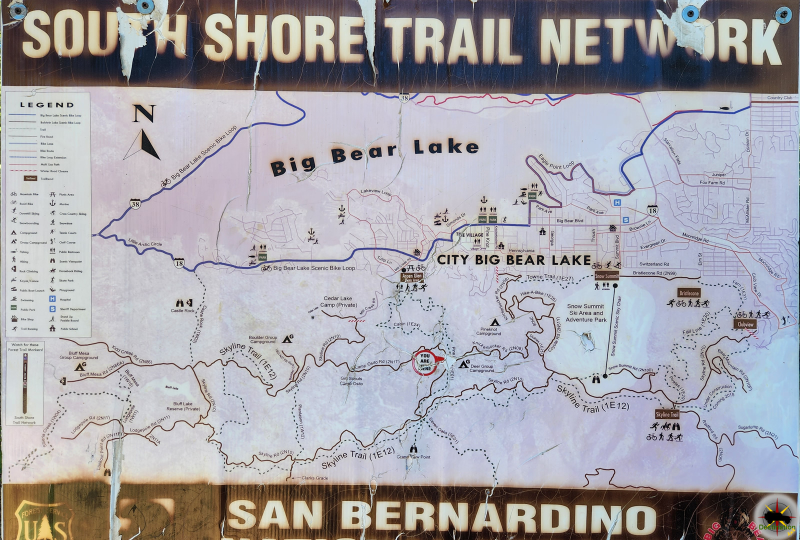
Clarks Grade 1N54 is a steep and scenic descent from the top of Skyline drive and Snow Summit down to Angeles Oaks from Big Bear. The trail is located in the San Bernardino Mountains of Southern California.  This road is steep enough, that low range will be utilized on the trail and four wheel drive is recommend. The trail starts at about 7800 feet in elevation, and over the course of its 7.6 mile length, drop down to 4800 feet. This is 3000 feet of elevation drop from the top of the trail to the bottom.

Last reports from Clarks Grade indicate decent sized rocks and rutting which will be of concern for some stock vehicles.

The Forrest Service routinely closes this trail during the winter due to snow, mud and / or heavy rain, which could cause excessive erosion to the trail.

A Forest Service Adventure Passes are required if you plan on stopping along the way. As of September 2016, forest visitors parked in standard amenity recreation fee sites in the four southern California national forests must display a valid recreation pass. This includes sites on the Angeles, Cleveland, Los Padres and San Bernardino National Forests. Such is the once great state of California.

Trail Summary

NameClarks Grade
LocationBig Bear, Sand Bernardino, California
Length7.6 Miles
Elevation change3000 feet
Forest Service Road1N54

Clarks Grade Trailmap


Camp Osito Road - 2N17 - Trailhead from Knickerbocker Road near Big Bear, California

Camp Osito Road – 2N17

Camp Osito Road is a back country 4x4 trail which connects Knickerbocker Road to Skyline Drive in Big Bear, California. The seldom travelled road is…
Clarks Grade 1N54 Trail Head dropping down into Barton Flats from Skyline Drive.

Clarks Grade 1N54

Clarks Grade 1N54 Trail Head dropping down into Barton Flats from Skyline Drive. Clarks Grade 1N54 is a steep and scenic descent from the top…
Big Bear Lake viewed from Knickerbocker Road.

Knickerbocker Road – 2N08

Knickerbocker Road - 2N08 is a steep and beautiful drive from near the town of Big Bear, California to Skyline Drive. The route is a…
Skyline Drive 2N10 offers higher elevation views of Big Bear, California

Skyline Drive 2N10

Skyline Drive 2N10 offers higher elevation views of Big Bear, California Skyline Drive 2N10 is the unofficial name for USFS Road 2N10 that begins just…