Butte Valley is a remote and captivating backcountry destination in the southwestern corner of Death Valley National Park, offering a blend of stunning geology, historical mining relics, and rugged off-road adventure. Situated at elevations ranging from about 3,800 to 4,500 feet, the valley is framed by the Panamint Mountains and features dramatic landscapes, including the iconic Striped Butte—a colorful, layered peak rising to 4,744 feet with bands of brown, yellow, orange, blue, and gray metamorphic rock. This area is not accessible by standard vehicles; it’s primarily reached via high-clearance 4×4 roads, making it ideal for experienced off-road enthusiasts rather than casual hikers. While there are no formal maintained trails within the valley itself, visitors often explore on foot once arrived, hiking short distances to viewpoints, cabins, or the butte. As of August 2025, road conditions can vary due to flash floods, erosion, and seasonal weather—always check the latest NPS updates before venturing out, as the park’s extreme heat (summer highs often exceed 120°F) and isolation demand thorough preparation.
Route Description and Access
The most common access to Butte Valley is via the Warm Springs Canyon Road, a challenging backcountry route starting from the Panamint Valley side (near Ballarat or Trona). This unpaved road stretches approximately 15-20 miles from the canyon entrance to the heart of Butte Valley, following a historic mining path past several abandoned talc mines. The drive typically takes 2-4 hours one-way, depending on vehicle speed and stops.
- Difficulty: Moderate to difficult for off-roading. The road includes steep grades, rocky sections, loose gravel, and potential washouts. High-clearance 4WD is required; aired-down tires and a spare are essential. Novices should avoid it, as recovery in this remote area can be costly and time-consuming.
- Length and Elevation: About 15 miles from Warm Springs Canyon entrance to Anvil Spring (the valley’s southern hub), with an elevation gain of around 2,000 feet. The road climbs through narrow canyons before opening into the brush-covered valley floor.
- Alternative Routes: For a more adventurous approach, enter via Mengel Pass from the west (extremely rough, with boulder fields and steep descents) or from the east through Death Valley proper, though these are less direct and often gated or restricted seasonally. Another option is the Striped Butte Valley 4×4 drive, starting from Badwater Road about 25.5 miles south of Badwater Basin, covering similar terrain.
- Current Conditions (as of Recent Reports): Roads are generally passable for properly equipped vehicles, but monsoon seasons (July-September) can cause flash flooding, leading to temporary closures. Winter may bring snow at higher elevations, while spring wildflowers can enhance the scenery. No recent major incidents reported, but always carry extra water, fuel, and communication devices like a satellite phone, as cell service is nonexistent.
Once in the valley, exploration is flexible. Park at Anvil Spring (a small oasis with limited water—treat before drinking) and hike short, unmaintained paths. A popular informal hike is ascending Striped Butte (1-2 miles round-trip, 500-700 feet elevation gain, Class 2 scrambling), offering panoramic views of the valley and surrounding ranges. Other foot explorations include visiting mining ruins or wandering the valley floor, but stick to established paths to minimize impact on fragile desert ecosystems.
Points of Interest
- Striped Butte: The valley’s namesake, a striking geological formation created by ancient metamorphic processes. It’s a photographer’s dream and a moderate hike from the valley floor.
- Geologist’s Cabin: A historic stone structure near Anvil Spring, open for day use (overnight stays require permits). It features a simple interior with a fireplace, tables, and shelves—respect the site and leave no trace.
- Other Historic Sites: Ruins of talc mines, a three-stamp gold mill northwest of Anvil Spring, and Stella’s Cabin (also known as Greater View Spring Cabin), associated with early prospectors.
- Natural Features: Sparse vegetation, wildlife like bighorn sheep or desert tortoises, and nearby canyons like Anvil Canyon for side explorations.
Tips for Visitors
- Permits and Regulations: Free backcountry permits are required for overnight camping; obtain them at visitor centers or online via NPS.gov. No fires allowed; pack out all trash.
- Safety: Bring at least 1 gallon of water per person per day, sun protection, and emergency supplies. The area is extremely remote—nearest services are over 50 miles away in Furnace Creek.
- Best Time to Visit: Late fall through early spring to avoid deadly heat. Four-wheel-drive clubs often run group trips for added safety.
- Environmental Note: Stay on roads to protect cryptobiotic soil; off-road driving is prohibited.
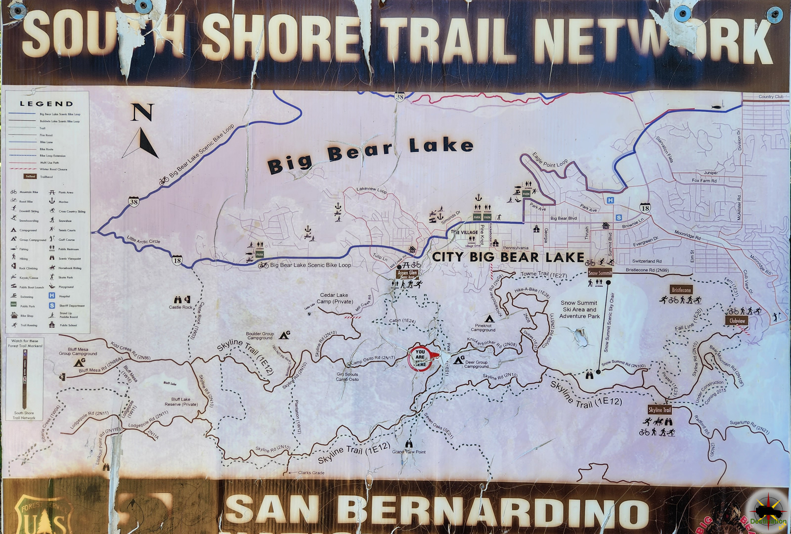
Trail Map
History of Butte Valley
Butte Valley’s human history spans millennia, beginning with Native American groups like the Timbisha Shoshone, who inhabited the broader Death Valley region as early as 1000 CE, using seasonal camps for hunting and gathering. European exploration intensified in the mid-19th century, with the 1849 “Forty-Niners” passing through during the California Gold Rush, though the valley itself saw limited activity until the 1870s.
Mining boomed in the late 1800s, driven by gold and silver discoveries. The Gold Hill mines north of the valley were among the first, recorded in the Cleaveland (later Panamint) Mining District. By 1889, the Butte Valley Mining Company was incorporated with a $300,000 capital stock, focusing on claims in Goler Canyon and nearby areas, including the Queen of Sheba and Belmont mines. Prospectors like J.A. Mack and D.R. Kimball worked rich veins of gold, silver, and tellurium in the 1890s, with placer gold yields reaching $20 per sack. The Anvil Spring area, initially called Anvil Springs and later Striped Butte, hosted up to 30 miners by 1899, with plans for stamp mills that were slow to materialize due to transportation challenges.
The early 1900s saw sporadic activity, with camps supporting companies and individual claims. Key figures emerged in the 1920s-1930s: Carl Mengel, a German prospector, filed claims like Topah and Mah Jongg in 1924 and is buried at Mengel Pass after his 1944 death. Asa “Panamint Russ” Russell built the Geologist’s Cabin in 1930 at Anvil Spring while mining gold near Manly Peak; he also discovered a rich vein with partner Ernie Huhn in 1925, though it was lost. Louise Grantham established a talc mining camp in the 1930s, operating eleven claims with Huhn’s help during World War II. The Western Talc Company employed workers here into the 1930s.
By the mid-20th century, mining waned, with only assessment work by owners like Clinton and Stella Anderson (who acquired Russell’s claims in 1962 and lived at Greater View Spring until the 1970s). The area’s inclusion in Death Valley National Monument (established 1933) shifted focus to preservation, though historical sites remain as testaments to the boom-and-bust era. Today, Butte Valley preserves this legacy amid its geologic wonders, reminding visitors of the hardy souls who sought fortune in one of Earth’s harshest environments.