
Big Bear, CA
I quiet mountain community full of back country adventure.
The Journey is the destination


Clarks Grade 1N54 is a steep and scenic descent from the top of Skyline drive and Snow Summit down to Angeles Oaks from Big Bear. The trail is located in the San Bernardino Mountains of Southern California. This road is steep enough, that low range will be utilized on the trail and four wheel drive is recommend. The trail starts at about 7800 feet in elevation, and over the course of its 7.6 mile length, drop down to 4800 feet. This is 3000 feet of elevation drop from the top of the trail to the bottom.
Last reports from Clarks Grade indicate decent sized rocks and rutting which will be of concern for some stock vehicles.
The Forrest Service routinely closes this trail during the winter due to snow, mud and / or heavy rain, which could cause excessive erosion to the trail.
A Forest Service Adventure Passes are required if you plan on stopping along the way. As of September 2016, forest visitors parked in standard amenity recreation fee sites in the four southern California national forests must display a valid recreation pass. This includes sites on the Angeles, Cleveland, Los Padres and San Bernardino National Forests. Such is the once great state of California.
| Name | Clarks Grade |
| Location | Big Bear, Sand Bernardino, California |
| Length | 7.6 Miles |
| Elevation change | 3000 feet |
| Forest Service Road | 1N54 |
 Camp Osito Road – 2N17Camp Osito Road is a back country 4x4 trail which connects Knickerbocker Road to Skyline Drive in Big Bear, California. The seldom travelled road is… |
 Clarks Grade 1N54Clarks Grade 1N54 Trail Head dropping down into Barton Flats from Skyline Drive. Clarks Grade 1N54 is a steep and scenic descent from the top… |
 Knickerbocker Road – 2N08Knickerbocker Road - 2N08 is a steep and beautiful drive from near the town of Big Bear, California to Skyline Drive. The route is a… |
 Skyline Drive 2N10Skyline Drive 2N10 offers higher elevation views of Big Bear, California Skyline Drive 2N10 is the unofficial name for USFS Road 2N10 that begins just… |
Willow Creek road is an easy gentle ride located near Big Bear, California. The easy trail runs from Hooks Creek Road to Highway 173 and offers excellent opportunities to get out and commune with nature.
Willow creek can get rather full after heavy rains, but for the most part this trail is suitable for most stock SUV’s and truck. The road is open to green sticker vehicles, so be cautious of oncoming traffic. Most of the route is dry and should not require four wheel drive. However higer ground clearance is a concern and four wheel is likely needed for one or two climbs.
A Forest Service Adventure Passes are required if you plan on stopping along the way. As of September 2016, forest visitors parked in standard amenity recreation fee sites in the four southern California national forests must display a valid recreation pass. This includes sites on the Angeles, Cleveland, Los Padres and San Bernardino National Forests. Such is the once great state of California.
| Name | Willow Creek |
| Location | Big Bear, San Bernardino, California |
| Length | 6.4 Miles |
| Elevation Gain | 950 Feet |
| Route Type | Out and Back |
| Difficulty | Moderate |
Snow Slide Trail (2N13) connects Green Valley Lake to Fawnskin, in San Bernardino, California. The Green Valley Lake trail head is located by the campground at the far end of town. The Fawnskin side trailhead is located about 5 miles out of the town on Rim of the World Drive.
From the Green Valley Lake side the trail winds along the mountain side, which was recently burned by fire. There is a lot of new growth in the burn area as the environment begins to heal itself. The burned area now offers wonderful views of the valley and not only reminds us to be careful with our natural areas, but also provides some insight into the dynamic resilience of nature.
Spring – 2013. The entire trail was open from the Green Valley Lake side, but closed at the intersection with Rim of the World Drive.
A Forest Service Adventure Passes are required if you plan on stopping along the way. As of September 2016, forest visitors parked in standard amenity recreation fee sites in the four southern California national forests must display a valid recreation pass. This includes sites on the Angeles, Cleveland, Los Padres and San Bernardino National Forests. Such is the once great state of California.

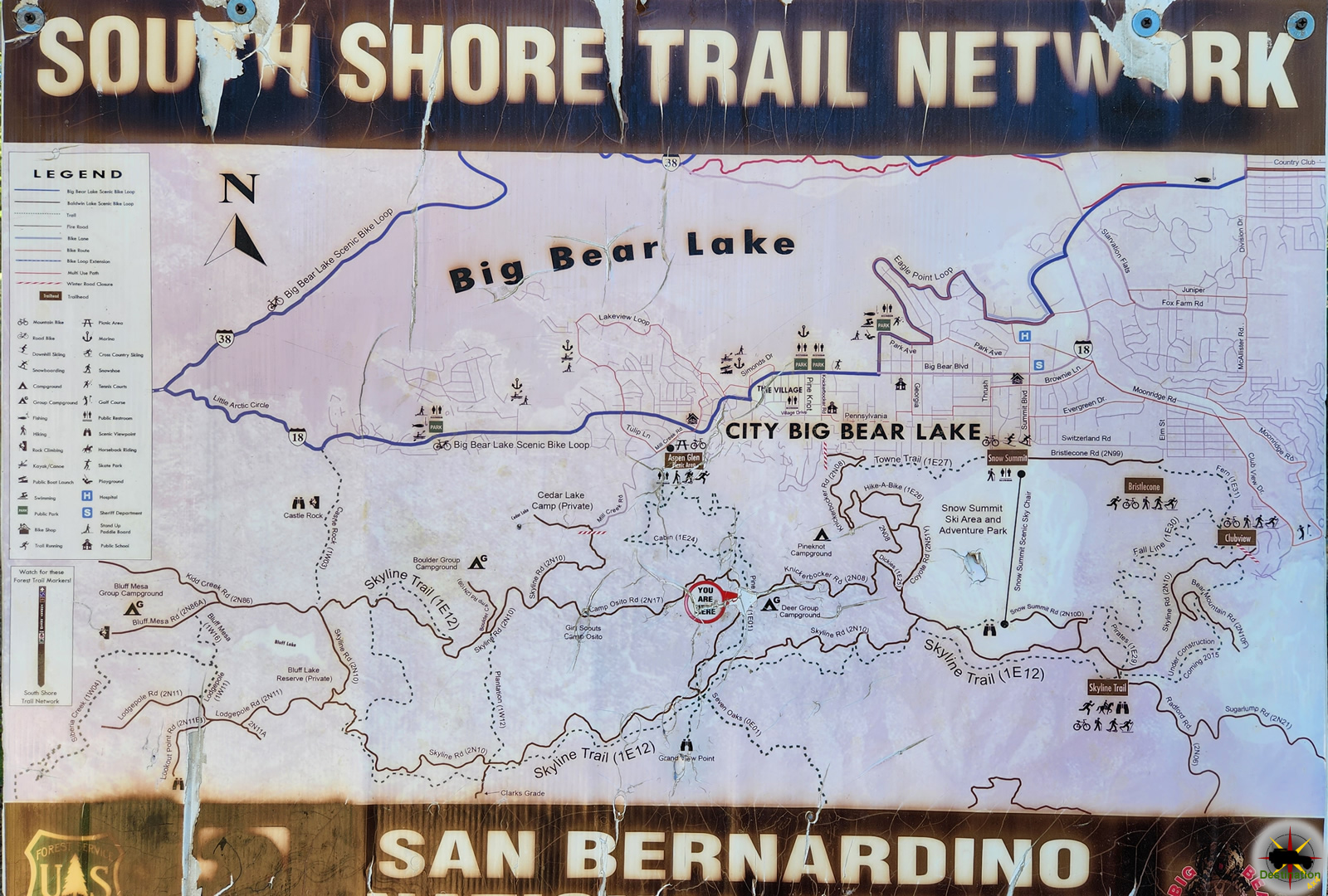
Skyline Drive 2N10 is the unofficial name for USFS Road 2N10 that begins just west of Big Bear village off Mill Creek road, and heads south into the mountains, then east along the ridge line behind Big Bear Village and Snow Summit, and eventually re-enters the valley in the upper Moonridge area.
This little adventure is a vehicle off road safari through one of the most beautiful parts of our Big Bear mountains. You don’t need a four wheel drive, but a 2 wheel drive vehicle with good ground clearance is recommended.
This scenic loop is a well maintained dirt road about 9 to 10 miles long. It can be driven straight through in about an hour or so, but plan on giving yourself plenty of time to occasionally stop to picnic, take photos, or just admire the views. There is a lot to see on this high country venture. Parts of Skyline Drive 2N10 are along the 8,000 ft ridge line providing spectacular panoramic views of San Gorgonio, the Santa Ana river, and Big Bear lake. On a clear day you can see all the way to Los Angeles and even Catalina island. Don’t leave your camera home on this adventure.
A Forest Service Adventure Passes are required if you plan on stopping along the way. As of September 2016, forest visitors parked in standard amenity recreation fee sites in the four southern California national forests must display a valid recreation pass. This includes sites on the Angeles, Cleveland, Los Padres and San Bernardino National Forests. Such is the once great state of California.
Skyline Drive is closed at the intersection with the Coyote Trail moving east. This Forest Service closure is the result of a recent wild fire. Caution should be taken, as this road is frequently used by 4×4’s, Dirt Bikes, Mountina Bikers and hikers alike.
Skyline Drive is part of the South Shore Trail Network.
Camp Osito Road – 2N17Camp Osito Road is a back country 4x4 trail which connects Knickerbocker Road to Skyline Drive in Big Bear, California. The seldom travelled road is… |
Clarks Grade 1N54Clarks Grade 1N54 Trail Head dropping down into Barton Flats from Skyline Drive. Clarks Grade 1N54 is a steep and scenic descent from the top… |
Knickerbocker Road – 2N08Knickerbocker Road - 2N08 is a steep and beautiful drive from near the town of Big Bear, California to Skyline Drive. The route is a… |
Skyline Drive 2N10Skyline Drive 2N10 offers higher elevation views of Big Bear, California Skyline Drive 2N10 is the unofficial name for USFS Road 2N10 that begins just… |
Also known as the Deep Creek Trail, Dish Pan Springs offers a short but hardcore trail in Big Bear. Dishpan springs trail contains large boulders and steep rocky climbs and the water crossing at Deep Creek to challenge the driver and the 4×4 on this trail.

The Deep Creek crossing on this trail was notorious for drowning engines, stalling trucks and causing everything, including the ‘Dishpan’ to float away. Since then, the forest service has “improved” the crossing. Crossing Deep Creek is no longer as difficult as it once was since the forest service has built a bridge. sigh…
The Eastern trail head is located out of Crab flats near Green Valley Lake. From highway 18, take the Green Valley Lake Road. Â After about 5 miles take a left on Crab Flats Road and follow the road down about 5 miles to the trail head.
Again from highway 18, take highway 173 into Arrowhead.  Continue on highway 173 until you reach Hook Creek Road.  Turn right onto Hook Creek road and stay on hook creek until you reach the trail head.
A Forest Service Adventure Passes are required if you plan on stopping along the way. As of September 2016, forest visitors parked in standard amenity recreation fee sites in the four southern California national forests must display a valid recreation pass. This includes sites on the Angeles, Cleveland, Los Padres and San Bernardino National Forests. Such is the once great state of California.