Lost Burro Mine

The Lost Burro Mine is one of the best-preserved historic gold mining sites in Death Valley National Park, California. Located in a remote draw at the northern end of the mountain range separating Hidden Valley from Racetrack Valley (near Teakettle Junction in the Ubehebe Mining District), the mine sits in rugged terrain accessible only by high-clearance 4WD vehicles via a rough 1-mile dirt track off the Hidden Valley road. Its isolation has helped protect the site from vandalism, making it a fascinating glimpse into early 20th-century prospecting life.

The Lost Burrow Mine is located off Hunter Mountain Road in Death Valley National Park, CA

Discovery (1907)

The story of the Lost Burro Mine began on April 18, 1907, with a classic tale of serendipity. Prospector Bert Shively, while searching for his stray burros in a remote canyon, picked up a rock intending to throw it at the animals to get their attention. Instead of tossing it, he noticed the rock was laced with visible free gold. Surface assays from the outcroppings reportedly ran from $40 to $1,000 per ton — incredibly rich values for the era.

Shively quickly filed six claims and partnered with others, securing options worth around $45,000. The accidental discovery turned the site into one of the most promising gold properties in the Ubehebe District (an area otherwise known more for lead, silver, and copper).

The Lost Burrow Mine

Early Development and Peak Years (1907–1910s)

Despite the financial panic of 1907, work continued at the Lost Burro, regarded as one of the richest claims in the district. Ore samples averaged high gold values (some reports cite up to $80–$1,450 per ton in early assays), and the mine attracted multiple ownership changes and optimistic plans.

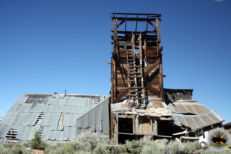
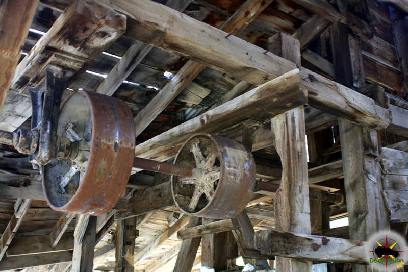
By the 1910s, development included short tunnels along the vein, with ore intersections averaging $25 per ton in later reports. Foundations were laid for a five-stamp mill and cyanide plant, intended to process ore on-site, with water piped in from Burro Spring (about 7.5 miles northeast on Tin Mountain) via a 2-inch pipeline. Remnants of this pipeline — along with rusted oil drums, tin cans, old chairs, and other debris — still litter the site.

The mine’s greatest production likely occurred between 1912 and 1917, though official records are sparse. It stands out as the only exclusively gold-bearing property in the Ubehebe District.

Later Operations and Decline (1920s–1970s)

The mine changed hands several times over the decades and was worked intermittently. In 1942, claims were relocated, and further amendments occurred in 1948 and 1970. A small amount of recorded production (about 255 ounces of gold between 1935 and 1942) exists, but unofficial estimates suggest the total lifetime output may have approached $100,000 in gold value.

Operations wound down by the 1970s, and the site was eventually incorporated into Death Valley National Park, where all mining claims became inactive.

The cabin found at the Lost Burrow Mine is in good shape.

Modern Legacy

Today, the Lost Burro Mine features a remarkably intact wooden cabin (in good condition, with stories of a “curse” leading some visitors to return removed artifacts), an outhouse, multiple adits (some used for storage), a one-chute ore bin, mill foundations stairstepping down the hillside, scattered machinery (including a small retort/smeltor and sluice box remnants), and tailings piles.

The site’s remoteness — requiring a challenging 4WD journey often combined with trips to the nearby Racetrack Playa — has kept it well-preserved and largely free of modern vandalism. Visitors are reminded to leave everything as found, as the area is protected wilderness.

The Lost Burrow Mine cabin interior

The Lost Burro Mine remains a testament to the tenacity of Death Valley prospectors — turning a frustrated burro chase into a legendary gold story in one of the harshest environments on Earth. Always check current road conditions and permits with the National Park Service before visiting!

Lost Burro Mine Video

Lost Burro Mine Trail Map

Ubehebe Lead Mine

The Ubehebe Lead Mine is located just west of theRacetrack Playa Road off of the Bonnie Claire Road.  Discovered in 1906, the mine is located on the west side of the Racetrack valley just south of Teakettle junction.    The site was started as a copper mine and during to coarse of its operation would produce lead, copper, gold and zinc.

Ubehebe Lead Mine Trail sign located just off of the Racetrack, Death Valley, CA
Ubehebe Trail sign located just off of the Racetrack, Death Valley, CA

Early Discovery and Initial Interest (1875–Early 1900s)

The deposit was first discovered by copper prospectors in 1875, with surface samples reportedly assaying as high as 67% copper. However, the extreme remoteness, lack of water, and poor transportation made development unfeasible at the time. The area saw little activity until the early 1900s, when rising copper demand (driven by widespread electrification) sparked renewed interest in Death Valley’s mineral prospects.

Ubehebe Mine with tramway visible at the top of the hill, Death Valley, CA

Boom Period and Jack Salsberry’s Involvement (1906–1908)

The modern era began in 1906, when the site gained attention amid the broader mining excitement in the region (including the short-lived Greenwater copper boom). Promoter Jack Salsberry (who later had Salsberry Pass named after him) acquired the property, built access roads from Ubehebe Crater, and promoted ambitious plans — including a proposed Bonnie Claire & Ubehebe Railroad to haul ore to Nevada rail lines. Some hype even linked it to legendary “Lost Spanish Mine” tales.

In February 1908, miners uncovered a thick vein of lead ore (described as up to eight feet wide), shifting focus from copper to lead and prompting the name change to Ubehebe Lead Mine. The first recorded production came that year, with shipments including 491 ounces of silver. Enthusiasm led to stockpiling 26,000 pounds of supplies for an eight-man crew, but assays and processing yielded far lower values than expected.

Exploring the Ubehebe Mine tails pile, Death Valley, CA

Intermittent Operations (1910s–1950s)

Production remained sporadic due to isolation, high transport costs, and inconsistent ore grades. Key highlights include:

  • 1916: Peak year, with 254 tons of 15% lead ore shipped.
  • 1930s: Successive lessees cleaned out old stopes; in 1937, operator Sol Camp attempted revival amid rising lead prices, contracting hauls to Death Valley Junction for shipment to Utah smelters.
  • 1940s–1950s: Activity continued on a small scale, with shipments in 1951 (averaging 13.8% lead, 4.93% zinc, 3.47 oz silver/ton) and 1952 (12.4% lead, 12.4% zinc, plus silver, copper, and gold). Total historical output from the broader Ubehebe Peak area (1908–1951) included thousands of tons of ore yielding significant lead (over 2.6 million pounds), plus zinc, silver, copper, and minor gold.

The nearby area also saw World War II use for aerial gunnery practice.

Decline and Modern Status

Operations wound down by the mid-20th century, with some reports of activity into the late 1960s. The mine never became a major producer due to logistical challenges. It is now within Death Valley Wilderness on National Park Service land — closed to mining, with no plans for reopening. The site serves as a fascinating (but dangerous) historical remnant of Death Valley’s mining era.

Looking back at the jeep, Death Valley National Park, CA

The Ubehebe Lead Mine exemplifies the boom-and-bust pattern typical of Death Valley mining: high hopes fueled by rich surface showings, dashed by the desert’s unforgiving realities. Access requires high-clearance (often 4×4) vehicles via the rough Racetrack Road — check current conditions with the National Park Service before visiting!

Ubehebe Mine Trail Map

Death Valley Campgrounds

Death Valley National Park

Emigrant Campground

Emigrant Campground is a tent only campground located next to CA Route 190 near the boundary of Death Valley National Park, California. The campgrounds is…
Death Valley National Park

Eureka Dunes Dry Camp

Eureka Dunes Campground is near a small localize sand dunes formation with Death Valley National Monument. Eureka Dunes Dry Camp is located next to the…

Furnace Creek Campground

Furnace Creek Campground is located at -200 below sea level in Death Valley National Park, California. The campground is the most popular in the Death…
Homestake, Death Valley

Homestake Dry Camp

Homestake Dry Camp - A primative campsite at Racetrack Valley The Homestake Dry camp is a primitive campground located in Racetrack valley inside Death Valley…
Death Valley National Park

Mahogany Flat Campground

Mahogany Flat Campground lies at 8,200 feet in the Panamint Mountain Range in Death Valley National Parl. The campground provides access to hiking and backpacking,…

Mesquite Springs Campground

Mesquite Springs Campground located near Scotty's Castle in Death Valley Mesquite Springs is a campground in Death Valley National Park, Located just a few short…
Sand dunes near Stovepipe Wells in Death Valley National Park

Stovepipe Wells

Stovepipe Wells Campgound is located in Stovepipe wells just off the 190 highway in Death Valley National Park. Located about 25 miles away from Furnace…
Sunset Campground located in Furnace Creek, Death Valley National Park. Photo by Heather Rathbun

Sunset Campground

Sunset Campground is another large, flat parking lot campground primary for RV camping located near Furnace Creek in Death Valley National Park, California. The Campground…
Death Valley National Park

Texas Springs Campground

Texas Springs Campground is another large campground, primarilyy for RV and trailer camping within Death Valley National Park. The campground a mile of the Furnace…
Death Valley National Park

Thorndike Campground

Thorndike campground is located at 7,400 feet in the Panamint Mountains in Death Valley National Park. The campground is accessible to high clearance vehicles only…
Death Valley National Park

Wildrose Campground

Wildrose Campground is located at 4100 feet above sea level in the Paramint Mountains within Death Valley National Park. This semi-primative campground is located off…

Death Valley Points of Interest

Artist's Palette, Death Valley National Park - Photo by James L Rathbun

Artist Drive

Artist Drive is perhaps one of the most popular and scenic drives through a colorful palette of geology, located in Death Valley National Park, California.…
Badwater Basin located at 282 feet below sea level in Death Valley National Park. - Photo by James L Rathbun

Badwater Basin

Badwater Basin, located in Death Valley National Park, Inyo County, California, is the lowest point in North America, sitting at 282 feet (86 meters) below…
Ballarat, California - Marriedtofilm at English Wikipedia - Transferred from en.wikipedia to Commons by Malafaya using CommonsHelper.

Ballarat California – Inyo County Ghost Town

Ballarat, California Located in Inyo County, Ballarat California is a ghost town which supposedly has a few residents living their dream within the town. Ballarat…
This image, taken circa 1940, shows the main residence, workshop, retaining walls, and ornamental vegetation. Note the windmill located behind the workshop. View north (DEVA collection) - NPS

Barker Ranch

Thomason/Barker Ranch is a five-acre property within Death Valley National Park. This historic site is located off of Goler Wash in the southern Panamint Range…
Cerro Gordo overlooking the then full Owens Lake.

Cerro Gordo California – Inyo County Ghost Town

Located in the Inyo Mountains on the eastern side of Owens Valley, Cerro Gordo California is a currently a ghost town after almost 100 years…
Crowells Mill under construction in Chloride City, CA about 1915

Chloride City California – Inyo County Ghost Town

Chloride City California is located within Death Valley National Park and Inyo County, California. The town arose out of silver discoveries in nearby Chloride Cliff…
Darwin Falls is a nice hike near Death Valley National Park, CA

Darwin Falls

The waterfalls of Darwin are located on the western edge of Death Valley National Park near the settlement of Panamint Springs, California. Although there exists…
Baldwin Locomotive No 1 Engine, D V R R

Death Valley Railroad

The Death Valley Railroad (DVRR) was a historic 3 ft (914 mm) narrow-gauge railroad that once operated in Death Valley. Built primarily to support mining…
A completely flattened structure at Goldbelt Springs, Death Valley, California - Photo by James L Rathbun

Goldbelt Springs

A discovery by the famous prospector "Shorty Harris", led to the founding on the Goldbelt Springs mining district off Hunter Mountain Road in Death Valley…
Greenwater Mining District, CA 1906

Greenwater California – Inyo County Ghost Town

In the scorched embrace of the Funeral Mountains, where the Mojave Desert meets the unrelenting heat of Death Valley, lies the spectral outline of Greenwater—a…
Cashier Mill ruin and Pete Aguereberry, 1916. From Dane Coolidge Collection,

Harrisburg California – Inyo County Ghost Town

Harrisburg, California, a now-abandoned ghost town in Inyo County, was a fleeting but significant mining camp in Death Valley’s history. Established in 1905 following a…
Henry Wade Escape Route Monument located on Highway 127

Henry Wade Escape Route

The Henry Wade Escape Route is an easy 4x4 trail suitable for almost any vehicle and connects highway 127 to Badwater Road. The route is…
Keane Wonder Mine - 1916 - Quartz mill. Mine said to have produced $1,000,000. Closed May 1916 as the developed ore bodies were worked out.

Keane Wonder Mine – “King of the Desert”

The Keane Wonder Mine is perhaps the most visited gold mining facility in Death Valley National Park in eastern California. Mining operations began in December…
Leadfield Sign, Death Valley, California

Leadfield California – A Death Valley Ghost Town

Leadfield California is a ghost town located in Inyo County and Death Valley National Park and found on the Titus Canyon Trail. The town boom…
The cabin found at the Lost Burrow Mine is in good shape.

Lost Burro Mine

The Lost Burro Mine is one of the best-preserved historic gold mining sites in Death Valley National Park, California. Located in a remote draw at…
Myers Ranch, Panamint Mountain

Myers Ranch

Myers Ranch is a privately owned ranch located in Goler Wash in the Panamint Mountains of Death Valley National Park, California. The forty acre ranch…
U2's Joshua Tree - 2016

One Tree Hill, A trip to the U2 Joshua Tree

A trip to the U2 Joshua Tree brought back a life time of memories. There was never a point in time that I was not…
Panamint City Stamp Mill

Panamint City California – Inyo County Ghost Town

Panamint City California - 1875 Panamint City California is a ghost town and silver mine site located in Inyo County. The town site was built…
The Racing stones.

Racetrack Valley

TeaKettle Junction lets you know you are starting to get close to the Racetrack. Racetrack valley is a rough graded road which departs the Ubehebe…
Rhyolite, Nevada photo by James L Rathbun

Rhyolite Nevada – Nye County Ghost Town

Rhyolite is a ghost town location just outside of the Eastern edge of Death Valley National monument in Nye country, Nevada.  Founded in 1904 by…
Photograph of the "Baby Gauge" (aka "Baby Gage") mine train at the mining camp of Ryan, Death Valley, ca.1900-1950. A car with one headlight can be seen at center on tracks pulling a platform with four benches upon it. Someone can be seen driving the car, while four men and women sit on the benches. A small wooden shack with a portion of the roof missing can be seen behind the platform, while a ladder, wooden planks, and more tracks are visible at left. A valley and mountains can be seen in the background. - “University of Southern California. Libraries” and “California Historical Society” as the source. Digitally reproduced by the USC Digital Library.

Ryan California – Inyo County Ghosttown

Perched precariously on the steep eastern flanks of the Amargosa Range at an elevation of 3,045 feet (928 meters), Ryan, California—once a thriving borax mining…
Schwab, California - “In the afternoon the townsite company drinks tea,” Death Valley Chuck-Walla magazine, Vol 2. No. 1, June 1907

Schwab California

Schwab is a gold mining camp and ghost town located in Echo-Lee Mining District of Death Valley National Park in California. The little townsite of…
Scotty's Castle located in Grapevine Canyon in Death Valley.

Scottys Castle – The Death Valley Ranch

Scottys Castle located in Grapevine Canyon in Death Valley. Named after Walter Scott AKA "Death Valley Scotty", Scottys Castle or the Death Valley Ranch is…
Skidoo, CA 1907

Skidoo California – Inyo County Ghost Town

Skidoo, California, once a bustling gold mining town in the early 20th century, now stands as a ghost town within Death Valley National Park. Located…
Teakettle Junction at the intersection of Hunter Mountain Road and Race Track Valley Road, Death Valley National Park, California - Photo by James L Rathbun

Teakettle Junction

Located at the intersection of Hunter Mountain Road and Race Track Valley Road, Teakettle Junction is a unique point of interest in Death Valley National…
The Arargosa Opera House is located in Death Valley Junction, California.

The Amargosa Opera House

Recently, on a whim, my wife and I loaded up the jeep and opt to just explore the desert West of our home town of…
Ubehebe Crater, Death Valley National Park, California - Photo by James L Rathbun

Ubehebe Crater

Ubehebe Crater is a volcanic crater located near Grapevine Canyon in Death Valley National Park in California. The crater is approximately 600 deep and one…
Ubehebe Mine with tramway visible at the top of the hill, Death Valley, CA

Ubehebe Lead Mine

The Ubehebe Lead Mine is located just west of theRacetrack Playa Road off of the Bonnie Claire Road.  Discovered in 1906, the mine is located…
Looking down at the Lippencott Mine Road from the Lippencott Mine, with Saline Valley in the distance.

Warm Springs Road

A short side trip from the Saline Valley Road to the Saline Valley Warm Springs in Death Valley National Park, California. The road is used…
Zabriskie Point bathed in warm afternoon light in Death Valley National Park - Photo by James L Rathbun

Zabriskie Point

Zabriskie Point is perhaps one of the best known and popular overlooks in the entire Death Valley National Park, California. The landmark is named for…

Lucy Grey Goldmine

The Lucy Grey Goldmine trail is a short 4×4 trip out of Primm, Nevada up to an old mine site.  The route is fairly accessible and almost any SUV or 4×4, but the route finding can be tricky is you are not careful.  A slight mistake in navigation and you will be in some rough country.  To find the trail head, exit and head past the outlet stores and the Lotto Store. The trail head is the dirt road where the paved road turns left.

Lucy Grey gold mine - An old truck marks the trail up to the mine. Built rigs might be able to make it, but I choose to hike. Photo by James L Rathbun
Lucy Grey gold mine – An old truck marks the trail up to the mine. Built rigs might be able to make it, but I choose to hike. Photo by James L Rathbun

The trail heads straight out into the desert. When you reach the railroad tracks, turn right and follow the road next to tracks until you reach a railroad signal station. There is a pass through under the train track and a nice little sign which reads Lucy Grey to let you know you are on your way.

From the railroad signal station the trail heads up an alluvial fan into the hills. Once you reach the gully and head into the hills, the trail becomes hard to follow, so pay attention to GPS coordinates, or your map. The trek is mostly easy with one or two small sections that will require you to pay a little more attention. The most difficult part of this trail is the route finding up to the mine and town site.

Continue Reading →

Chemung Mine

Located off the Masonic Road between Bridgeport, CA and the Masonic town site, are the remains of the Chemung gold mine.  The Chemung gold mine operated from from 1909 to 1938 and produced over one million dollars in gold.  In the 1920s, the Chemung mine was producing low grade and high grade ore.  The ore was processed onsite, and then shipped to near by Bodie for smelting.

The Chemung Mine located just outside of Bridgeport, CA. Photograph by James L Rathbun

Along with the increase cost of mining supplies which reduced growth, a poor gold market and the cost of hauling the ore to Bodie over the poor roads for smelting and little mine was doomed and closed its doors in 1938.

The Chemung mine history is not a mining failure, but a failure of management and litigation.  During its time of production, the mine built and tore down three mills.  During the last year of operation in 1938, 20 men worked the site and less than one year later the mine was closed.  The mine itself produced well, however endless litigation for various reasons doomed the mine.

The Chemung gold mine over looking the Bridgeport Valley.. Photograph by James L Rathbun

Throughout the 1950s and 1960s new life was found in the mine with the efforts of Elton “Heinie” Heinemeyer.  Heinemeyer mined for years but never struck it big.  Well liked by the town of Bridgeport, CA Heinemeters well being was the source of concern for the people of Bridgeport and it is reported that he would always find time to visit and entertain those who traveled to check up on him.

Currently, the mill building structure is intact but the years of harsh weather have taken its toll.  A mild wind will cause some of the walls to shake or shudder, and the lower outer wall is leaning outward.  In June 2016, bars restricted access to the mines themselves although the mines do offer a cold breeze on a warm day to cool you down.

The Chemung mine still maintains and impressive structure. Photograph by James L Rathbun

There are stories that the site is haunted by a spirit or ghost, but only on Saturday nights, which seems a bit odd to me.

The Chemung Mine working still seem ready to go. Photograph by James L Rathbun

On a personal note, the Chemung mine surprised me.  I have been to Aurora three times, Masonic at least three times, and Bodie… at least ten.  My last visit to Bodie was in 2013. Afterwards this last trip, I was looking in Google Earth when I “discovered” the Chemung gold mine.  How had this mine, such an impressive structure, evaded my radar for so many years?  It took me three years from that day to make my first visit to Chemung, and this place is definately on my list for a repeat visit.

Time, weather and gravity have taken its toll on the structure of the Chemung Mine.. Photograph by James L Rathbun
Time, weather and gravity have taken its toll on the structure of the Chemung Mine. Photograph by James L Rathbun

Chemung Mine Trailmap

Resources

Potosi Nevada – Clark County Ghost Town

Potosi Nevada is the oldest lode mine in Nevada and the town site is located just off highway 160 between Las Vegas and Pahrump, Nevada.  The site was started in 1856 by some Mormon prospectors who were lead to the location with the help of a Piute guide.  The Mormons found the site in April 1856 and a month latter it was named Potosi after the boyhood home of Nathaniel Jones.  They did not begin mining until August after a return trip to Utah for supplies.  

Potosi mine, south center of sec. 12, T. 23 S., R. 57 E., the mine workings explore a zone at the base of the Yellowpine limestone. Clark County, Nevada. Circa 1921. Plate 33-B in U.S. Geological Survey. Professional paper 162. 1931.

By September, the first wagon of ore sent back to Utah for trading and three months later three wagons returned with supplies including bellows, furnace, and hearths among other things.  On Christmas day 1856, an crude adobe furnace was used to smelt ore.

In the spring of 1861, a larger smelter was setup by the Colorado Mining Company at the Potosi Spring.  News of new silver mine spread all over the west in no time.  The town of Potosi was setup 700 feet below of the Potosi Mine or the Las Vegas Silver Mines as they were called and was soon home to 100 miners.

Carol Lombard was killed on a Douglas DC-3, Jan 16, 1942 on Mt Potosi

The site continued to slowly grow and develop until 1906.  In 1913 the Empire Zinc Company purchased the rights and was soon Potosi was Nevada’s largest producer of Zinc.  After nearly 100 years of production Potosi produced about 4.5 million in lead, silver and zinc.

Potosi is a designated at Nevada State Historic Marker no. 115.

Town Summary

NamePotosi
LocationClark County, Nevada
GNIS849366
Latitude, Longitude35.9708, -115.5408
Elevation5705
Population100

Potosi Trailmap

References