Robert Holland Vance

Robert Holland Vance (1825–1876) was a pioneering American photographer known for his work during the California Gold Rush. Born in Maine, he trained in daguerreotype photography and established studios in Boston before moving to San Francisco in 1850. Vance became a leading figure in California photography, operating galleries in multiple cities, including Sacramento and San José. He is credited with some of the earliest photographic records of the American West, including a notable 1851 exhibition of over 300 California daguerreotypes in New York. His work captured significant events, like the 1856 San Francisco lynching of James P. Casey, and possibly included early images of California’s Native Americans. A savvy entrepreneur, he advertised in multiple languages and amassed significant wealth before financial setbacks led him to relocate to New York in 1865, where he continued his career until his death.

Early Life and Background

Robert Holland Vance was born in 1825 in Baring Plantation, Maine, to William Vance and his fourth wife, Charlotte Holland. His early life was marked by instability; when he was eight, his family relocated to Kennebec County, Maine, where his parents’ divorce and his father’s subsequent remarriage disrupted his childhood. The Vance children were placed under the guardianship of Lot M. Morrill, a future governor of Maine. It is believed that Robert received his initial photographic training from his brother William, a successful photographer, and further honed his skills through apprenticeships in New England studios. Following his father’s death when Robert was 16, a three-year court battle resulted in an inheritance that allowed him to establish his first daguerreotype gallery in Dover, New Hampshire. By age 21, he was operating a studio at 91 Washington Street in Boston in partnership with John A. Lerow.

Career Beginnings and Move to California

Vance’s early career was shaped by the daguerreotype, a pioneering photographic process. After gaining experience in Boston, he traveled to South America and Chile, likely to expand his photographic ventures. In 1850, drawn by the California Gold Rush, Vance relocated to San Francisco, where he became a leading figure in photography. He capitalized on the demand for cartes-de-visite and ambrotypes, boasting that his thick glass ambrotypes would “last forever.” His preference for large-format cameras for landscapes contrasted with his use of small-format cameras for studio portraits, which he believed produced superior results.

By the end of the 1850s, Vance operated portrait galleries in San Francisco, Sacramento, San José, Virginia City, Carson City, and later Hong Kong. A natural promoter, he advertised in multiple languages (Spanish, Chinese, French, and German) and claimed to use pure silver and specially formulated chemicals for his plates. He also boasted of having the largest skylight in the world at his San Francisco studio, located at Sacramento and Montgomery Streets. His business acumen led to real estate holdings valued at over $40,000 by 1860, earning him the self-proclaimed title of the “father of California photography.”

Notable Contributions and Exhibitions

In 1851, Vance made a significant mark by exhibiting over 300 daguerreotype views of California in New York City, showcasing the landscapes and life of the burgeoning state. These works, described as “Views in California,” were later acquired by Jeremiah Gurney and John Fitzgibbon but have since been lost. The exhibition, though not a commercial success, highlighted Vance’s ambition to document the American West. He is also credited with possibly taking the first photographs of California’s Native American populations, though these images are unconfirmed. His galleries employed notable photographers, including Carleton Eugene Watkins, who managed one of Vance’s studios and later became a renowned landscape photographer. Vance’s photographs of the 1862 Sacramento Flood were widely reproduced as engravings, further cementing his influence.

One of Vance’s notable works is a whole-plate daguerreotype documenting the 1856 lynching of James P. Casey, who murdered James King of William, editor of the San Francisco Evening Bulletin. This photograph, housed at the Metropolitan Museum of Art, captures a pivotal moment in San Francisco’s history, reflecting the vigilantism of the city’s Committee of Vigilance.

Later Years and Legacy

Vance’s success was not without challenges. Over-speculation in the stock market led to the closure of his California businesses in 1864. In 1865, he relocated to New York, where he continued his photographic work until his death in 1876. His brother, William Vance, also a photographer, remained active in California from 1854 to 1861 and 1872 to 1885.

Robert H. Vance’s legacy lies in his pioneering role in California photography during the Gold Rush era. His studios produced some of the earliest visual records of the American West, influencing the development of photography as both an art and a commercial enterprise. His work, preserved in institutions like the Metropolitan Museum of Art, continues to offer insight into the cultural and historical landscape of 19th-century America.

Aurora, Nevada 1860-1960: Mining Camp, Frontier City, Ghost Town

Aurora Nevada Mining Camp

This expanded Second Edition of Aurora, Nevada 1860-1960 chronicles the history of one of Nevada’s earliest and most important mining boomtowns. It is a reference-oriented book, which includes hundreds of edited and annotated newspaper clippings and other firsthand accounts about Aurora’s buildings, businesses, major mines, social life, Paiute citizens, ghost town days, and final destruction over the entire length of its century-long history. This new edition has 98 additional pages with a new section on violence at Aurora during 1863 and 1864, more information about the Daly gang, complete directories for the boom years 1864, 1880, and 1915, and an annotated list of residents from 1861-1864 and 1880. The book now includes 14 maps and over 200 photographs.

Author’s Note

A “Second Edition” (ISBN 978-1979848862) and newer hardcover “Second Color Edition” (ISBN 979-8507081967) of this book are now available on Amazon., Despite a century of history, and the valiant efforts of all those who believed the town would last forever, Aurora, Nevada, is now and forevermore a “Colossal Wreck” slowly returning to its beginnings-a sagebrush and pinyon pine covered valley home to jackrabbits and a few ghosts from the past. While Aurora is gone, its historical record remains, thus providing us the opportunity to reconstruct the town and its society if only in our imagination. Most historical accounts about Aurora have focused on the town during its early 1860s mining boom. However, Aurora’s rich and colorful history deserves a closer look. This new reference-oriented publication includes hundreds of edited and annotated newspaper clippings and other firsthand accounts about Aurora’s buildings, businesses, major mines, social life, Paiute citizens, ghost town days, and final destruction over the entire length of its century-long history. It also includes directories for the boom years 1864, 1880, and 1915, as well as 6 maps and over 150 photographs, many of which are “then and now” comparisons of the same view., Author’s Note: This book is the original edition but there is also a new revised and expanded “Second Edition” (search ISBN 978-1979848862) of this book now available on Amazon for the same price on a different Amazon page. The Second Edition has 98 additional pages that include 50 new photographs, 6 more maps, an expanded 1864 directory, and a new list of Aurora residents from 1861-1864.

Book Summary

TitleAurora, Nevada 1860-1960: Mining Camp, Frontier City, Ghost Town (Second Edition)
Author Clifford Alpheus Shaw
PublisherCreateSpace Independent Publishing Platform 
Edition2nd Edition
Pages488 Pages

Ely Forging The Link – Nevada State Historic Marker

The “Forging the Link” historical marker in Ely, Nevada, encapsulates the story of a town that became a vital hub in the American West due to its strategic location and economic contributions. The marker, part of Nevada’s historical marker program overseen by the State Historic Preservation Office (SHPO), commemorates Ely’s role in connecting the region through mining, transportation, and community development.

Early Exploration and Mapping (1859)

James H. Simpson (1813–1883)

The story of Ely begins with its placement on the map by James H. Simpson during his 1859 exploration of the Great Basin. As a U.S. Army officer, Simpson conducted surveys to identify potential routes for communication and travel across the vast, arid region. His work highlighted Ely’s strategic position, laying the groundwork for its future development as a regional center. This initial mapping was critical, as it introduced Ely to the broader narrative of westward expansion and connectivity in the United States.

Mining Boom and Economic Growth (1860s–1890s)

In the 1860s, the discovery of silver and gold deposits in the nearby Robinson Mining District spurred interest in the area. These discoveries attracted prospectors and settlers, transforming Ely into a burgeoning hub. By 1887, Ely had grown sufficiently to become the county seat of White Pine County, solidifying its administrative importance. The real economic surge came in the early 1890s with the discovery of significant copper deposits. Copper mining became the backbone of Ely’s economy, drawing investment and labor to the region and necessitating infrastructure to support the industry.

The Nevada Northern Railway (1900s)

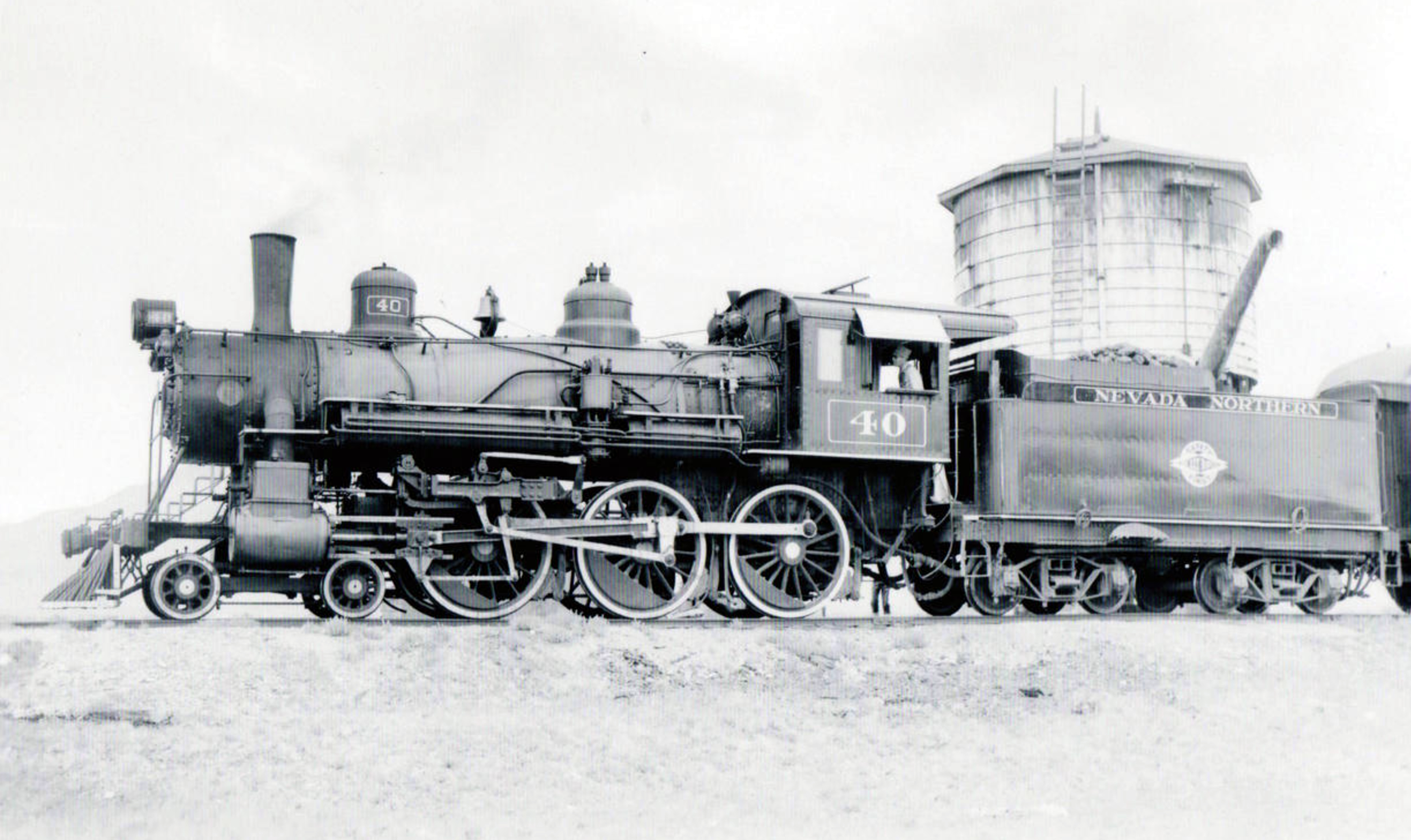
A pivotal development in Ely’s history was the establishment of the Nevada Northern Railway, headquartered in East Ely. Completed in the early 20th century, this 150-mile railway connected Ely’s mines in Ruth to a smelter in McGill and linked the town to the transcontinental railroad to the north. The railway was instrumental in transporting copper ore and other goods, effectively “forging the link” between Ely and national markets. This connectivity not only boosted Ely’s economy but also positioned it as a critical node in the supply chain of the American West, facilitating trade and communication across vast distances.

Nevada Northern Railway

The Lincoln Highway and Road Networks (1913–1922)

Ely’s role as a transportation hub was further cemented in 1913 when the transcontinental Lincoln Highway, one of America’s first coast-to-coast automobile routes, was routed through the town. Although the road was not paved until 1922, its inclusion of Ely underscored the town’s importance as a stopping point for travelers crossing the Great Basin. By the late 19th century, Ely was already connected by a network of wagon roads, but the Lincoln Highway elevated its status. Additionally, two other major roadways—U.S. Route 6 (designated in 1937, formerly the Midland Trail) and U.S. Route 93—converged at Ely, making it a crossroads for travelers moving between Canada, southern California, and beyond. With over 2,000 residents by the early 20th century, Ely offered essential services, making it an ideal stop for weary travelers.

The Historical Marker’s Creation

The “Forging the Link” marker, erected by the Nevada State Historic Preservation Office, was designed to capture Ely’s multifaceted role in connecting the Great Basin through exploration, mining, and transportation. While the exact date of the marker’s installation is not specified in available records, it is part of a broader initiative to document Nevada’s history through physical markers. The marker’s title, “Forging the Link,” reflects Ely’s historical significance as a connector—geographically, economically, and socially—in a region characterized by its isolation.

The marker likely emerged from a collaborative effort involving local historians, community members, and the SHPO, which oversees Nevada’s historical marker program. Such markers are typically proposed by local groups or agencies, such as the Bureau of Land Management’s Ely District, to highlight significant historical narratives. The content of the marker emphasizes Simpson’s exploration, the mining boom, the Nevada Northern Railway, and the Lincoln Highway, weaving together the threads of Ely’s development into a cohesive story of regional importance.

Significance and Legacy

The “Forging the Link” marker serves as both an educational tool and a point of pride for Ely’s residents. It highlights the town’s resilience and adaptability, from its origins as a mapped point in the Great Basin to its growth into a mining and transportation hub. The marker also underscores Ely’s enduring role as a service center for travelers, a legacy that continues with its position at the intersection of major highways. For visitors, the marker offers a glimpse into the challenges and triumphs of life in the American West, particularly in a region as remote as White Pine County.

Today, the marker stands as a testament to Ely’s historical contributions and its ongoing relevance. It invites reflection on how infrastructure and economic activity can transform a small town into a vital link in a larger network, a theme that resonates with Nevada’s broader history of connectivity and development.

James H. Simpson put the future site of Ely on the map during his 1859 exploration through the Great Basin.  In the 1860s, silver and gold deposits were discovered nearby in what became the Robinson Mining District.  Ely developed as a regional center, becoming the White Pine County seat in 1887.  The area grew dramatically in the early 1890s with major copper discoveries.  The Nevada Northern Railway, headquartered in East Ely, carried ore from the mines in Ruth to the McGill smelter, as well as connecting Ely to the world on its 150 mile route north to the transcontinental railroad.

The towns of eastern Nevada were joined during the late nineteenth century by a network of wagon roads.  In 1913, the road through Ely was incorporated into the transcontinental Lincoln Highway, though it was not paved until 1922.  Ely had over 2,000 residents and offered many services, making it an excellent stopping place on the long road across the Great Basin.  When the copper industry declined after World War I, the struggling town turned to travelers for income.

The Lincoln Highway was designated U.S. 50 in 1926.  By mid-century the popularity of the Victory Highway, now Interstate 80, reduced U.S. 50 to the status of “The Loneliest Road in America.”

In addition to the Lincoln Highway, two other major national roadways converge at Ely.  The Midland trail, designated Route 6 in 1937, was an early coast to coast automobile road that also connected Ely to Tonopah and southern California.  U.S 93, which passes north-south through Ely takes travelers from Canada almost to the Mexican border.

STATE OF NEVADA HISTORIC PRESERVATION OFFICE

AT&T

Land Services, Inc.

MACTEC Engineering and Consulting, Inc.

Ely Renaissance Society

Bureau of Land Management, Ely District

Nevada State Historic Marker 269 Map

Nevada State Historic Marker Summary

NameEly Forging The Link
LocationEly, White Pine County, Nevada
Latitude, Longitude39.2488, -114.8902
Nevada State Historic Marker269

John Wesley Powell

John Wesley Powell, a remarkable American explorer, geologist, and ethnologist, was born on March 24, 1834, in Mount Morris, New York. His expeditions through the uncharted territories of the American West not only added to scientific knowledge but also provided invaluable insights into the land’s geological and cultural diversity. Powell’s legacy as a pioneer of exploration and his tireless efforts in promoting conservation measures have left an indelible mark on American history.

Powell served as the second Director of the United States Geological Survey, a post he held from 1881 to 1894. This photograph dates from early in his term of office.

Early Life and Education

Powell grew up in rural New York, where his love for nature and the outdoors was nurtured from an early age. Although he lost his right arm in a childhood accident, Powell’s determination and thirst for adventure were undeterred. He developed a keen interest in natural sciences and geography and pursued higher education at Illinois College and later at Oberlin College, where he focused on geology.

Grand Canyon Expeditions

Powell’s most famous and daring expedition was his 1869 journey down the Colorado River, known as the Powell Geographic Expedition. With a team of nine men, Powell set out to explore the largely uncharted canyons and rapids of the Colorado River and gather valuable scientific data. The expedition faced numerous hardships, including treacherous rapids, scarce food supplies, and hostile encounters with Native American tribes. Miraculously, Powell and his crew successfully navigated the treacherous river and completed the journey, providing unprecedented knowledge of the Grand Canyon and its geological formations.

First camp of the John Wesley Powell expedition, in the willows, Green River, Wyoming, 1871. - E. 0. Beaman - War Department. Office of the Chief of Engineers. Powell Survey. (1869 - ca. 1874)
First camp of the John Wesley Powell expedition, in the willows, Green River, Wyoming, 1871. – E. 0. Beaman – War Department. Office of the Chief of Engineers. Powell Survey. (1869 – ca. 1874)

Powell’s subsequent expeditions further solidified his reputation as a fearless explorer. He embarked on multiple journeys across the American West, including explorations of the Green and Colorado Rivers, the Rocky Mountains, and the Uinta Mountains. Powell’s meticulous record-keeping and scientific observations greatly expanded the understanding of the region’s geology, hydrology, and ethnography.

Scientific Contributions

Powell’s expeditions were not merely adventurous endeavors but also scientific ventures aimed at advancing knowledge in various fields. He published numerous papers and reports detailing his findings, including “Exploration of the Colorado River of the West and its Tributaries” and “Canons of the Colorado.” These works significantly contributed to the geological understanding of the American West, shaping subsequent research and studies in the region.

Additionally, Powell’s expertise in ethnology led him to conduct extensive research on Native American tribes. He documented their cultures, languages, and customs, recognizing the importance of preserving their heritage. His ethnographic studies formed a crucial foundation for future anthropological research in the United States.

Conservation Advocacy

John Wesley Powell was not only a scientist and explorer but also an early advocate for conservation. Recognizing the fragile nature of the American West’s ecosystems, he became a vocal proponent of sustainable land use practices and preservation efforts. Powell believed that the arid region’s limited water resources necessitated careful management and planning.

In 1879, Powell presented his influential “Report on the Lands of the Arid Region of the United States” to Congress. This groundbreaking report emphasized the need for responsible irrigation and land development strategies, urging policymakers to consider the long-term consequences of uncontrolled resource exploitation. Powell’s report laid the groundwork for the eventual establishment of the U.S. Forest Service and the Bureau of Reclamation, both crucial agencies in land and water management.

Legacy and Impact

John Wesley Powell’s contributions to exploration, science, and conservation continue to resonate today. His expeditions not only unveiled the wonders of the American West but also inspired future generations of explorers and scientists. Powell’s emphasis on interdisciplinary research and his understanding of the intricate relationships between humans and their environment remain

References

Jarbidge Community Hall – Nevada State Historic Marker 153

The Jarbidge Community Hall is a central gathering place for the residents of Jarbidge, Nevada. Built in 1939, the hall has served as a venue for community events, meetings, and social gatherings for more than 80 years. The hall is located on the main street of Jarbidge, and its distinctive Art Deco design makes it a landmark in the town.

The history of the Jarbidge Community Hall is intertwined with the history of the town itself. Jarbidge was founded in the late 19th century, during Nevada’s mining boom. The town was named after a nearby creek, and its population grew rapidly as miners flocked to the area in search of gold and silver.

Jarbidge Community Hall, Jarbidge, Elko county, Nevada

By the early 20th century, Jarbidge had become an important mining town, with several mines operating in the area. The town’s population peaked in the 1920s, with around 1,500 residents. During this time, the town was home to several businesses, including hotels, saloons, and general stores.

However, the Great Depression hit Jarbidge hard, and the town’s mining industry began to decline. By the late 1930s, many of the mines had closed, and the town’s population had dwindled to just a few hundred people.

Despite the difficult times, the residents of Jarbidge remained committed to their community. In 1939, they came together to build a place to gather within the town. The building was designed by local architect Paul Revere Williams, who was one of the few African American architects working in the United States at the time. Williams was known for his Art Deco designs, and the Jarbidge Community Hall is one of his few surviving buildings in Nevada.

The Jarbidge Community Hall was built using local materials, including stone from a nearby quarry and wood from the surrounding forests. The hall’s Art Deco style is evident in its streamlined design, geometric shapes, and use of decorative elements such as the zigzag patterns on the building’s façade.

Over the years, the building has served as a venue for a wide range of events. In the early days, it was used for dances, social gatherings, and community meetings. During World War II, it was used as a venue for USO shows and other events to support the war effort. In the decades that followed, it continued to be a central gathering place for the residents of Jarbidge, hosting everything from weddings and birthday parties to town meetings and political rallies.

Today, the Jarbidge Community Hall remains an important part of the town’s identity. It is still used for community events and social gatherings, and it serves as a reminder of the town’s rich history and strong sense of community. The hall has been listed on the National Register of Historic Places since 1990, and it is considered one of the most significant Art Deco buildings in rural Nevada.

In recent years, the Jarbidge Community Hall has undergone several renovations to ensure that it remains a functional and attractive venue for the town’s residents. The building’s stone façade has been restored, and the interior has been updated with new flooring and lighting. The hall is now fully accessible, with a wheelchair ramp and updated restrooms.

Despite its small size, the Jarbidge Community Hall is a testament to the resilience and determination of the people of Jarbidge. It is a symbol of the town’s enduring spirit and its commitment to preserving its history and traditions for future generations.

Nevada State Historic Marker Text

Gold discoveries by Dave Bourne in 1909 created the town of Jarbidge.

With 1,500 population in Jarbidge Canyon by 1910, citizens built this pioneer-type community hail with a “floating” maple floor.  Support from the Nevada Commission for Cultural Affairs and the community funded the restoration of the building.

STATE HISTORIC MARKER NO.  153
STATE HISTORIC PRESERVATION OFFICE
JARBIDGE COMMERCIAL HALL FUND AND IMPROVEMENT CLUB

Nevada State Historic Marker 153 Location

Jarbidge Community Hall Summary

NameJarbidge Community Hall
LocationJarbidge, Elko County, Nevada
Latitude, Longitude41.8783, -115.4303
Nevada State Historic Maker 153

References