The Pony Express Trails and Stations In Nevada

The Pony Express operated for a very brief period of time from April 3, 1860, to October 26, 1861. The mail service allowed quick delivery of mail, messages and newspapers between California and Missouri. The pony express was built and operated around one hundred and eighty six stations, which enabled a rider to change horses frequently and quickly traverse the county.
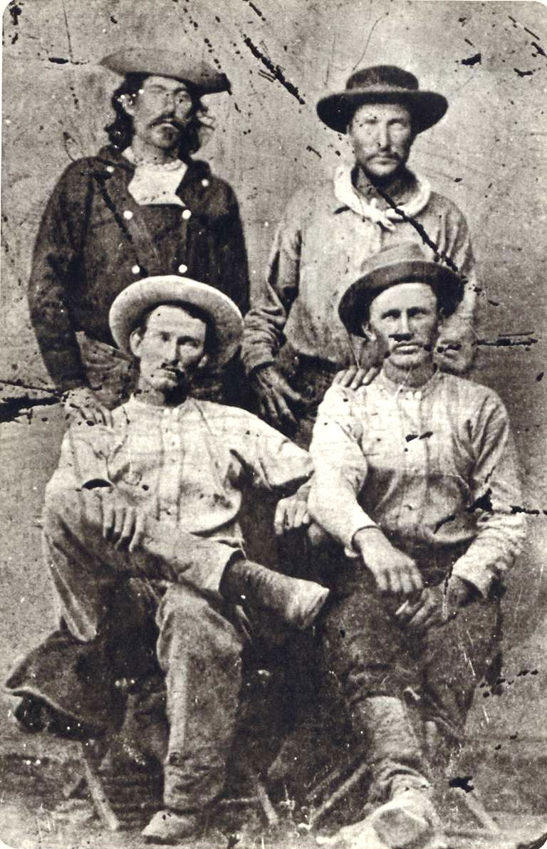
Pony Express Riders "Billy" Richardson, Johnny Fry, Charles Cliff, Gus Cliff - Ernest and Elaine Hartnagle (original tintype from the Martin E. Ismert Collection - Kansas City, Missouri) - http://www.historybuff.com/library/refrichardson.html
Pony Express Riders “Billy” Richardson, Johnny Fry, Charles Cliff, Gus Cliff – Ernest and Elaine Hartnagle (original tintype from the Martin E. Ismert Collection – Kansas City, Missouri) – http://www.historybuff.com/library/refrichardson.html

The Pony Express only operated for a brief 18 months. Yet, the lore of its riders racing the mail across the country maintains a special place in history. The service was not a financial success and heavily subsidized. Despite this influx of capital, the service was doomed on October 24, 1861 with the success of the transcontinental telegraph.

A Brief History

The Pony Express started to fill a need caused by the growing populations of California. After the discovery of Gold in 1848, thousands streaked to the golden state to seek their fortune in the ground. Additional demand for mail service was caused from migration along the infamous Oregon Trail and the Utah Mormon exodus in 1847. Stage Service was used to transfer correspondence across the Western United States.

Pony express route April 3, 1860 - October 24, 1861 - Jackson, William Henry, 1843-1942.
Pony express route April 3, 1860 – October 24, 1861 – Jackson, William Henry, 1843-1942.

The service was built and organized by three men, William Russell, Alexander Majors, and William B. Waddell. These men formed the company Russell, Majors & Waddell and in just two months in the winter of 1860 organized 184 stations, 80 riders and 400 hundred horse to race mail from St. Joseph, Missouri to Sacramento, California. Some of the stations were existing stage stops while others were purpose built humble buildings deep in the Nevada territory. They hoped with a 10 day delivery time they could secure government contracts. The costs of the expedited service was 25000% greater that the slower stage service and a 1/2 package would cost $5 at the time.

“Men Wanted”

The undersigned wishes to hire ten or a dozen men, familiar with the management of horses, as hostlers, or riders on the Overland Express Route via Salt Lake City. Wages $50 per month and found.

Ad in the Sacramento Union, March 19, 1860

The riders would received their delivery and store them in a special mail pouch or mochila. The rider would travel from station to station and changed horses at each station about every 10 miles. Every third station, or so, is designated as a home station, where extra horses, firearms, men and provision are kept. Weight was an important factor. Riders, horses, letters, and gear were all chosen with this in mind. The horses averaged about 14 1/2 hands high and weighed less than 900 pounds. The riders would be changed every 75 to 100 miles and road 24 hours a day. A pony express rider earned $125 / month which was a good salary for the time

The last day of the pony express was October 26, 1861. On this day, the transcontinental telegraph completed the first direct communication between san Francisco and New York. On that day, the pony express officially became too slow, too expensive and ceased operations.

Illustrated Map of Pony Express Route in 1860 by William Henry Jackson ~ Courtesy the Library of Congress ~ The Pony Express mail route, April 3, 1860 – October 24, 1861; reproduction of Jackson illustration issued to commemorate the 100th anniversary of Pony Express founding on April 3, 1960. Reproduction of Jackson's map issued by the Union Pacific Railroad Company.
Illustrated Map of Pony Express Route in 1860 by William Henry Jackson ~ Courtesy the Library of Congress ~ The Pony Express mail route, April 3, 1860 – October 24, 1861; reproduction of Jackson illustration issued to commemorate the 100th anniversary of Pony Express founding on April 3, 1960. Reproduction of Jackson’s map issued by the Union Pacific Railroad Company.

Nevada Pony Express Stations

Pony Express Rider Oath

I, … , do hereby swear, before the Great and Living God, that during my engagement, and while I am an employee of Russell, Majors, and Waddell, I will, under no circumstances, use profane language, that I will drink no intoxicating liquors, that I will not quarrel or fight with any other employee of the firm, and that in every respect I will conduct myself honestly, be faithful to my duties, and so direct all my acts as to win the confidence of my employers, so help me God.”

Oath sworn by Pony Express Rider

Pony Express Trail Map

Buckland Station early 1900s

Buckland’s Station

Buckland Station is a pony express station, stage stop, boarding house and supplier near Fort Churchill in Lyon County, Nevada. The station is designated as…
King Street, General View, 1880, Carson City, Carson City, NV

Carson City Station – Pony Express Station

Carson City Station was a pony express station located between on Carson Street between Forth and Fifth Street in Carson City, Nevada. Founded in 1858,…
Churchill County, Nevada

Cold Springs Station – Churchill County

Churchill County, Nevada Cold Springs Station, located in Churchill County, Nevada, along U.S. Highway 50 (known as the "Loneliest Road in America"), played a key…
Union Hotel, Dayton, built in the early 1870s - Chester Barton collection

Dayton Station – Pony Express

Dayton, Nevada is a small unincorporated community, and the location of the Dayton Station Pony Express stop in Lyon County, Nevada. The little town of…
Diamond Springs Station

Diamond Springs Station

Diamond Springs Station is a Pony Express Station number 133 and located in a meadow in Eureka County, Nevada. Today the station is on private…
Ghost Towns of White Pine County, Nevada

Eightmile, Nevada – White Pine County Ghost Town

Ghost Towns of White Pine County, Nevada Eightmile (also known as Eight Mile or Eight Mile Station) is a historic locale and ghost town site…
Nevada Hills Gold Mine, Fairview, Nevada

Fairview, Nevada – Churchill County Ghost Town

Located against the stark western flanks of Fairview Peak in southeastern Churchill County, Nevada, the ghost town of Fairview stands as a weathered echo of…
A lithograph drawing of Fort Chuchill, Nevada Territory created by Grafton Tyler Brown in 1862

Fort Churchill Nevada

Fort Churchill is a Civil War era United States Army Fort, Pony Express Station and overland stage stop located in Lyon County, Nevada just West…
Friday's Station was a Pony Express station at Lake Tahoe - (Nevada Historical Society

Friday’s Station – Pony Express

Friday's Station is Union Army Military Post and Pony Express Station located near Lake Tahoe, in Douglas County, Nevada. The two story building is originally…
Simpson expedition, Genoa, Nevada, 1859

Genoa Station – Pony Express

Originally part of the Utah Territory, Genoa is a former Pony Express Station and unincorporated community in Douglas County, Nevada. The settlement was first founded…
Winchester Firearms adopted the image of a Pony Express Rider.

Miller’s Station – Pony Express

Miller's station, also known as Reed's Station is a pony express station located in Churchill County, Nevada. Winchester Firearms adopted the image of a Pony…
Ragtown, Nevada

Ragtown, Nevada – Churchill County Ghost Town

Ragtown Nevada is ghost town and Nevada State Historical Marker number nineteen. The town and Nevada State Historic Marker are located in the Churchill County,…
Ruby Valley, White Pine County, Nevada - Ruby Valley Pony Express Station - photo taken in 1944

Ruby Valley Station

n was started in 1859 as part of George Chorpenning's mail route. Later the station served the Pony Express and Overland Mail Company line in…
Churchill County, Nevada

Sand Springs Station, Nevada – Churchill County Ghost Town

Churchill County, Nevada Sand Springs Station, located in Churchill County, Nevada, is a historic site best known as a relay station on the Pony Express…
Pony Express Riders "Billy" Richardson, Johnny Fry, Charles Cliff, Gus Cliff - Ernest and Elaine Hartnagle (original tintype from the Martin E. Ismert Collection - Kansas City, Missouri) - http://www.historybuff.com/library/refrichardson.html

The Pony Express Trails and Stations In Nevada

The Pony Express operated for a very brief period of time from April 3, 1860, to October 26, 1861. The mail service allowed quick delivery…
Van Sickle's Station 1870

Van Sickle’s Station – Pony Express

The Van Sickle's Station is the second Pony Express Station encountered when traveling east from Friday’s Station at the California/Nevada State Line. The Van Sickle…

References

The Lucky Day Mine

The Lucky Day Mine is a gold and copper mine located in San Bernardino, California and once owned by Wyatt Earp. Wyatt Earp is probably to most infamous gun fighter and law man who worked all across the western United States including Alaska.

Wyatt and Josephine Earp in the Lucky Day Mine mining camp near Vidal, California: This is the only confirmed picture of the two of them together.
Continue Reading →

The Plank Road

The old plank road was unique solution to the common problem of sand dunes in the south west and the last link to connect San Diego, California with Yuma Arizona. The plank road was a 6.5 miles long road which was built from wooden planks and floated on the shift sands of the Algodones Sand Dunes.

The Plank Road –  SD Automotive Museum
"Colonel" Ed Fletcher (December 31, 1872 – October 15, 1955) California Senator
“Colonel” Ed Fletcher (December 31, 1872 – October 15, 1955) California Senator
Continue Reading →

Potholes California – Colorado River Steamship Landing

Potholes, California, is a former gold mining camp and short-lived settlement in Imperial County on the west bank of the Colorado River, near the present-day site of Laguna Dam (about 15–18 miles upriver from Fort Yuma / Yuma, Arizona, and roughly 4 miles northeast of Bard). It sits in the southeastern Chocolate Mountains at the edge of what is now the All-American Canal system. The site is a ghost town with little remaining surface evidence of its mining or steamboat eras; a cemetery lies about a mile south along the riverbank.

Potholes California

Early Spanish Mining and Loss of Knowledge

Placer gold deposits at the “Pot Holes” (natural depressions in the desert gravels) were likely worked by Spanish miners associated with Mission San Pedro y San Pablo de Bicuñer, established in 1781 near the site. Knowledge of the diggings was largely lost after the Yuma (Quechan) uprising of 1781, in which the missionaries and settlers were killed. The location remained obscure for decades.

Rediscovery and 19th-Century Placer Mining

In early 1859, placer gold was rediscovered about 15 miles above Fort Yuma on the California side of the Colorado. Contemporary reports (including from the Daily Alta California) described paying claims: one operation reportedly yielded $200 per day for a short period, with others producing $10–$16 per day. Miners carried dirt to the river to wash in cradles; better results were expected if water could be brought to the diggings for sluicing. Mining continued intermittently through the later 19th century, largely by Hispanic prospectors familiar with dry-washing techniques suited to the arid environment. Estimates suggest hundreds of Mexican miners worked the district at peak times. A failed dredging attempt on the river near the site in 1900–1901 recovered little gold because the particles were too fine for the equipment. Total historical production from the district has been estimated in the range of around $2 million (period values).

There has been some little excitement in this part of the, country, caused by the discovery of new gold fields on the Rio Colorado, some fifteen miles above Fort Yuma, on the California side. I have just returned from the diggings, and find, after a careful examination of three days, that gold exists there in paying quantities, for many miles on both sides of the river. While at the newly discovered diggings, a considerable quantity of the oro has been taken out, considering the short time- they have been worked. From the claim of Messrs. Crandell & Co., $200 per day have been dug daily for the past six days. The manner of working is the same at at Jila city, heretofore described. The earth must be carried on the back a distance of one mile, and washed in a cradle. It is said that the total amount of the gold taken from Crandell & Co ‘s claim is about $4,000. – They have now constructed a cart-road from the mine to the river, and hereafter will be able to work at better advantage. Several other claims in the vicinity are paying from $10 to $16 per day; but most of the claims — for a good manner have been located — will not pay more than $2 per day to the hand, by the present process of working. If water could be obtained and sluice* used, from $40 to $100 per day might be washed. [We had news of these diggings in oar San Diego correspondence, published this morning, and the corroborating testimony of .our Fort Yuma correspondent is of much value, as confirmatory of the reports from San Diego. — Eds. Alta.]

I think, however, that the Gila mines are much more valuable, or will yield much more gold than these new diggings on the Colorado. Th« former have the advantage of being easily supplied with water, works for that purpose being now in progress.

Mining operations resumed again in 1859 with the rediscovery of gold. Placier mining operations proved successful in the 19th century. A steamship landing was established to ferry people and supplies to the location 15 miles up river from Yuma, Arizona.

The town of Potholes California was established during the building of the All American Canal and Laguna Dam.

Daily Alta California, Volume XI, Number 42, 12 February 1859

Role as a Colorado River Steamboat Landing and Supply Point

From 1852 to 1909, shallow-draft paddle-wheel steamboats were the primary commercial transportation on the lower Colorado River, moving people, military supplies, mining equipment, food, and ore between the Gulf of California (and later ocean connections) and upriver settlements and mines as far as the Virgin River area. George A. Johnson & Company (later the Colorado Steam Navigation Company) dominated the trade after early experiments with vessels such as the Uncle Sam (1852) and General Jesup.

Potholes appears on historical lists of steamboat landings beginning in 1859, located roughly 18 miles (29 km) above Fort Yuma. A landing was established specifically to deliver people and supplies to the newly active gold diggings. It served the local mining camp and the surrounding area (including the nearby Laguna placers across the river in Arizona Territory that opened around 1860). Steamboats provided a far cheaper and more practical alternative to overland wagon freight across the desert. Landings like Potholes functioned as local hubs: boats tied up overnight (night navigation was too hazardous on the shifting, shallow, sandbar-filled river), took on wood fuel cut by local Indigenous workers, discharged cargo for the mines and camps, and loaded any ore or goods for the return trip. This river network supported the broader mining boom of the 1860s along the lower Colorado and enabled isolated desert camps to obtain provisions that would otherwise have been prohibitively expensive.

Steamboat traffic declined after railroads reached the region (notably the Southern Pacific’s arrival at Yuma in the late 1870s) and effectively ended with the completion of Laguna Dam in 1909, which blocked further upriver navigation.

Early 20th-Century Construction Camp and Post Office

A town named Potholes was re-established (or formalized) during construction of Laguna Dam (completed 1909) and related work on the All-American Canal system, which diverted Colorado River water for Imperial Valley irrigation. A post office operated there from 1905 to 1909 and again from 1920 to 1922. The settlement was also served by a short Southern Pacific Laguna Branch railroad spur. Once the major construction projects finished and steamboat service ceased, the community faded. The canal and dam works altered the landscape, and much of the earlier mining and mission-era evidence was affected by flooding or later infrastructure.

Legacy

Potholes illustrates the layered history of the lower Colorado River corridor: early Spanish exploration and mining, mid-19th-century gold rushes sustained by steamboat logistics, and early-20th-century water infrastructure that transformed the desert into irrigated farmland. Today the site is largely unmarked and accessible mainly via local roads near Laguna Dam; remnant activity has been limited to occasional recreational prospecting. Its brief but documented role as a steamboat landing underscores how river transport once linked remote mining camps to distant supply centers, enabling settlement and extraction in an otherwise isolated frontier.

Town Summary

NamePotholes, California
LocationImperial County, California
Latitude, Longitude32.8289329, -114.5046713
Elevation160 feet
GNIS247730
Post Office1905 – 1909, 1920 – 1922

Potholes California Map

References

Nivloc Nevada – Esmeralda County Ghost Town

In 1907, Gold was discovered at the town site which would be known as Nivloc Nevada by a Native American prospector. The town derived its name from for the former owners “Colvin” who operated the site in 1923. The name spelled backwards was Nivloc and such is the haste in the Nevadan desert.

Nivloc mine and camp - Tonopah Times-Bonanza -  Nevada Ghost Towns and Mining Camps - Paher
Nivloc mine and camp – Tonopah Times-Bonanza – Nevada Ghost Towns and Mining Camps – Paher

The original mining operations were short lived. The town experienced a bit of a resurgence in the 1930s. The town never amounted to much boasting only one saloon. At its height of operation from 1940 to 1943 the town could claim a post office. Between 1937 and 1943 the small town produced between $2 and $3 million dollars of Gold and Silver. The 400,000 tons of ore was pulled from mines reaching depths 440 feet and 600 feet of below the surface. During this time, the mines of Nivloc ranked as Nevada’s number one silver producer.

Nivloc Today

We have not made a trip to Nivloc, however the townsite is very high on my ghost town “to do” list. There are several standing structures and buildings intact. The mine headframe is still standing at and a rail trestle bridge which is one hundred and twenty feet in length and forty feet tall.

Town Summary

TownNivloc, Nevada
LocationEsmeralda County, Nevada
Latitude, Longitude37.71583, -117.75722
Elevation6,170 feet
GNIS851592
Post OfficeOctober 1940 to November 1943

Nivloc Map

Resources