
Big Bear, CA
I quiet mountain community full of back country adventure.
The Journey is the destination


The Pony Express operated for a very brief period of time from April 3, 1860, to October 26, 1861. The mail service allowed quick delivery of mail, messages and newspapers between California and Missouri. The pony express was built and operated around one hundred and eighty six stations, which enabled a rider to change horses frequently and quickly traverse the county.
The Pony Express only operated for a brief 18 months. Yet, the lore of its riders racing the mail across the country maintains a special place in history. The service was not a financial success and heavily subsidized. Despite this influx of capital, the service was doomed on October 24, 1861 with the success of the transcontinental telegraph.
The Pony Express started to fill a need caused by the growing populations of California. After the discovery of Gold in 1848, thousands streaked to the golden state to seek their fortune in the ground. Additional demand for mail service was caused from migration along the infamous Oregon Trail and the Utah Mormon exodus in 1847. Stage Service was used to transfer correspondence across the Western United States.

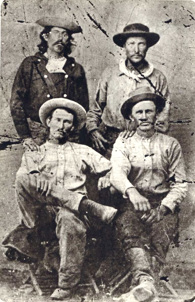
The service was built and organized by three men, William Russell, Alexander Majors, and William B. Waddell. These men formed the company Russell, Majors & Waddell and in just two months in the winter of 1860 organized 184 stations, 80 riders and 400 hundred horse to race mail from St. Joseph, Missouri to Sacramento, California. Some of the stations were existing stage stops while others were purpose built humble buildings deep in the Nevada territory. They hoped with a 10 day delivery time they could secure government contracts. The costs of the expedited service was 25000% greater that the slower stage service and a 1/2 package would cost $5 at the time.
“Men Wanted”
The undersigned wishes to hire ten or a dozen men, familiar with the management of horses, as hostlers, or riders on the Overland Express Route via Salt Lake City. Wages $50 per month and found.
Ad in the Sacramento Union, March 19, 1860
The riders would received their delivery and store them in a special mail pouch or mochila. The rider would travel from station to station and changed horses at each station about every 10 miles. Every third station, or so, is designated as a home station, where extra horses, firearms, men and provision are kept. Weight was an important factor. Riders, horses, letters, and gear were all chosen with this in mind. The horses averaged about 14 1/2 hands high and weighed less than 900 pounds. The riders would be changed every 75 to 100 miles and road 24 hours a day. A pony express rider earned $125 / month which was a good salary for the time
The last day of the pony express was October 26, 1861. On this day, the transcontinental telegraph completed the first direct communication between san Francisco and New York. On that day, the pony express officially became too slow, too expensive and ceased operations.

I, … , do hereby swear, before the Great and Living God, that during my engagement, and while I am an employee of Russell, Majors, and Waddell, I will, under no circumstances, use profane language, that I will drink no intoxicating liquors, that I will not quarrel or fight with any other employee of the firm, and that in every respect I will conduct myself honestly, be faithful to my duties, and so direct all my acts as to win the confidence of my employers, so help me God.”
Oath sworn by Pony Express Rider
 Buckland’s StationBuckland Station is a pony express station, stage stop, boarding house and supplier near Fort Churchill in Lyon County, Nevada. The station is designated as… |
 Carson City Station – Pony Express StationCarson City Station was a pony express station located between on Carson Street between Forth and Fifth Street in Carson City, Nevada. Founded in 1858,… |
 Dayton Station – Pony ExpressDayton, Nevada is a small unincorporated community, and the location of the Dayton Station Pony Express stop in Lyon County, Nevada. The little town of… |
 Diamond Springs StationDiamond Springs Station is a Pony Express Station number 133 and located in a meadow in Eureka County, Nevada. Today the station is on private… |
 Fairview Nevada – Churchill County Ghost TownLocated against the stark western flanks of Fairview Peak in southeastern Churchill County, Nevada, the ghost town of Fairview stands as a weathered echo of… |
 Fort Churchill NevadaFort Churchill is a Civil War era United States Army Fort, Pony Express Station and overland stage stop located in Lyon County, Nevada just West… |
 Friday’s Station – Pony ExpressFriday's Station is Union Army Military Post and Pony Express Station located near Lake Tahoe, in Douglas County, Nevada. The two story building is originally… |
 Genoa Station – Pony ExpressOriginally part of the Utah Territory, Genoa is a former Pony Express Station and unincorporated community in Douglas County, Nevada. The settlement was first founded… |
 Miller’s Station – Pony ExpressMiller's station, also known as Reed's Station is a pony express station located in Churchill County, Nevada. Winchester Firearms adopted the image of a Pony… |
 Ragtown NevadaRagtown Nevada is ghost town and Nevada State Historical Marker number nineteen. The town and Nevada State Historic Marker are located in the Churchill County,… |
 Ruby Valley Stationn was started in 1859 as part of George Chorpenning's mail route. Later the station served the Pony Express and Overland Mail Company line in… |
 The Pony Express Trails and Stations In NevadaThe Pony Express operated for a very brief period of time from April 3, 1860, to October 26, 1861. The mail service allowed quick delivery… |
 Van Sickle’s Station – Pony ExpressThe Van Sickle's Station is the second Pony Express Station encountered when traveling east from Friday’s Station at the California/Nevada State Line. The Van Sickle… |
The Lucky Day Mine is a gold and copper mine located in San Bernardino, California and once owned by Wyatt Earp. Wyatt Earp is probably to most infamous gun fighter and law man who worked all across the western United States including Alaska.

The old plank road was unique solution to the common problem of sand dunes in the south west and the last link to connect San Diego, California with Yuma Arizona. The plank road was a 6.5 miles long road which was built from wooden planks and floated on the shift sands of the Algodones Sand Dunes.


The Gunfight at the O.K. Corral is one of the most famous events in the history of the American Wild West. It occurred on October 26, 1881, in Tombstone, Arizona Territory, and was a culmination of long-standing tensions between two groups: the Earp brothers—Wyatt, Virgil, and Morgan—along with their ally, Doc Holliday, and the Clanton-McLaury faction, which consisted of cowboys Ike and Billy Clanton, Tom and Frank McLaury, and Billy Claiborne. The confrontation lasted just 30 seconds but left three men dead—Tom McLaury, Frank McLaury, and Billy Clanton—and became a symbol of the lawless nature of the American frontier.

The gunfight was sparked by a series of disputes over cattle rustling, stagecoach robberies, and political control in Tombstone. The Earp brothers, who were lawmen, and Doc Holliday, a gambler and gunman, sought to maintain order, while the Clanton-McLaury group represented the lawlessness that plagued the region. Although the gunfight took place near the O.K. Corral, it actually occurred in a narrow lot on Fremont Street, a detail often overlooked in popular culture. The aftermath of the shootout led to a complex legal battle and further violence, cementing the event’s place in American folklore and solidifying Wyatt Earp’s reputation as a legendary figure of the Old West.
Testimony of Thomas Keefe
in the Preliminary Hearing in the Earp-Holliday Case,
Heard before Judge Wells Spicer
November 10, 1881
On this tenth day of November, 1881, on the hearing of the above entitled cause, on the examination of Wyatt Earp and J. H. Holliday; Thomas Keefe, a witness of lawful age, being produced and sworn, deposes and says as follows:
Thomas Keefe, carpenter. To interrogation, says he saw a difficulty between Wyatt Earp and Thomas McLaury on October 26, 1881, to wit: “Around the corner of Fourth Street, about 50 feet from Allen Street, between there and Judge Wallace’s court, I do not remember the exact time of day-it was about 12 o’clock I think-the man that Wyatt Earp had trouble with was walking towards Allen Street on Fourth Street. Mr. Earp was going from Allen Street towards Wallace’s Court when they met. I did not understand what they said, and the fight commenced. I saw Mr. Earp knock McLaury down with his pistol, twice-I saw him fall twice-McLaury threw up his arms to knock the blows of the pistol off. Mr. Earp then put his pistol up and walked away from him. I couldn’t say there were over two blows struck with the pistol. I could not swear to any more. McLaury then got up and staggered and walked toward the sidewalk and picked up a silver band or roll, to put on his hat again, that was knocked off. That was the last I saw of him, McLaury, for half an hour. He walked away. I saw no other blows struck, excepting those that were struck with the pistol. I did not hear any words pass between the parties. I was about 22 or 23 feet from them. There were other parties nearer to the difficulty than I was.”
To further questioning, says he was at the scene of the killing, “after the killing was done.” The shooting was over. He was at Fourth and Allen when the first shot was heard by him, “and I ran down Allen Street to Third Street, from Third to the corner of Fremont.” My attention was called then to a man lying on the corner of Third and Allen Streets. It was Tom McLaury. He was dying. I called two or three men and said, “Let’s pick this man up and take him in the house before he dies.” We brought him in the house and got a pillow and laid him on the carpet and made him as easy as I could. I asked him if he had anything to say before he died and he made no answer. He could not speak. Then I unbuttoned his clothes and pulled his boots off and gave him some water, and the other man was halloing so with pain I sent for a doctor to inject morphine in him. I believe his name was Billy Clanton. The doctor arrived there then, and I helped the doctor inject morphine in him, alongside the wound. He was turning and twisting, and kicking in every manner, with the pain. He said, “They have murdered me! I have been murdered! Chase the crowd away from the door and give me air!” The last words he said before he died were, “Drive the crowd away!” I stayed there until the Coroner came; about eight or ten minutes afterwards.
Does not know who helped him carry Tom McLaury into the house-“Everything was all excitement.” Says there were four or five men there. Did not see any arms on Tom. Again tells of unbuttoning Tom’s clothing, “and as soon as Doctor Matthews came, we searched the body and did not find any arms on him. We examined him close enough to see if there were any arms on him, and there were none on him; we only found money on him.”
Tells of running to where Tom was lying, in the street, and says that three or four other men came up about the same time. He raised up Tom’s head. Again declares that there were no ammunition or arms on Tom at that time, nor on the ground near or about him, nor on his person, nor was there any belt on him. Says when they took Tom into the house, Billy Clanton was there, and Mr. Noble and Mr. Campbell, the Clerk of the Board of Supervisors, and another man who stops at Vogan’s, “I don’t know his name.”
As questions continue, he says he examined Billy Clanton and found he was shot through the right wrist, his arm was broken; he was shot on the left side of the belly; he was shot below the left nipple and the lung was oozing blood out of the wound; he was shot again through the pants of the right leg-it did not touch the skin. Says he examined the right wrist closely, even “ran my finger into the wound, feeling the bone.” Says the ball passed through the arm about two inches above the knuckle joint of his wrist.
CROSS EXAMINATION
To questions:
Says he has lived here about one year. Came from Bodie, California, where he lived two years and a half, before that lived in Oakland, California, eight months; before that about one year in San Francisco. Worked as a carpenter and builder in Bodie. Has been busy at this trade, “pretty near all the time,” in Tombstone. Did not know Billy Clanton nor the McLaury brothers, but knew Ike Clanton about two weeks before the shooting. Had no business relations with Ike Clanton, and denies receiving either promise or money from Ike Clanton or anyone else connected with the prosecution. Says he knows William Allen for two or three months.” Says Billy Clanton was in the house when they brought Tom in. Tells of sending for doctor and of Dr. Miller coming. Says he told the doctor to inject morphine into the wound near the stomach says Billy was “halloing” for morphine [because of pain]. Says he held Billy on his back while the doctor injected; that it was before the injection that Billy said he had been murdered; that he died, “about 10 or 15 minutes” after the injection of “two syringe fulls; morphine syringes; about the thickness of a small sized lead pencil about two inches long.”
In response to question as to shot in wrist: “It went from the inside to the outside.” Course of ball was diagonal across the wrist [here witness illustrates upon the arm of Mr. Fitch, the direction in which the ball passed through the arm of Billy Clanton, by showing that the ball entered the wrist nearly in line with the base of the thumb and emerged on the back of the wrist diagonally.] Says the orifice on the outside of the wrist was the largest. Did not see any powder bum on Billy Clanton’s body or clothing.
(A) Bauer, the butcher, denies having conversed with anyone outside counsel for the prosecution prior to giving testimony. Is asked if he sought Mr. McLaury or not. Says this man sought him for three days. Then his various positions prior to and during the shooting are restated.
Says his relations with Isaac Clanton were not intimate, but that he conversed with him on the day of the shooting at Hafford’s Comer, about 20 minutes or half an hour before the shooting.
(Q) Was anyone with Tom McLaury when he was hit by Wyatt Earp?
(A) I could not say.
(Q) Did you ever reside in the state of Nevada?
(A) I did.
(Q) When and where?
(A) At White Pine, Hamilton County, Virginia City, and Pioche in 1869-70-71 and ’72. [Some of these places are not on modem maps.]
(Q) Were you at any time during your residence in Nevada, defendant in any action wherein the State of Nevada was plaintiff in any criminal action?
(A) I was not.
(Q) How long after Tom McLaury was carried into the house was it before he died?
(A) Six or seven minutes.
(Q) Did Dr. Miller treat Tom McLaury also?
(A) No sir.
To query, says there was no weapon on William Clanton, but there was a cartridge belt on him, and a pistol was lying near the door-a Smith & Wesson, large-sized-about two feet from the door-on the carpet. Says he picked [the] pistol up, examined it and thought there were two empty chambers. “Then Wes Fuller examined it and said there were three empty, and I looked again and saw that three chambers were empty.” Doesn’t know whose pistol it was. Dr. Matthews took it. Says Frank McLaury was not brought into this room. He remained there until Tom’s and Billy’s bodies were taken away in a wagon.
(Q) Were you not, during your residence in Bodie, during the times you have already testified to, a portion of that time, confined in jail there? [Objection]
(A) I was arrested and put in jail and honorably acquitted. I was in jail for entering my own house after coming back from Idaho and dispossessing a certain gentleman who was living there.
(Q) Go on and state all about the matter about which you have testified to in your last answer upon cross-examination.
(A) I went to the Yankee Fork Country, Idaho, the first of March, two years ago. I left Bodie. Was gone eight months and came back and heard some very bad talk in regard to my family arrangements-and a man named Don McShannon. I approached him upon the subject and he denied all charges in regard to being intimate with my woman. I requested him to leave the house and rapped at the door and was shot at through the door and I was arrested and put in jail. I was then tried and acquitted honorably [All the foregoing is crossed out, beginning with, “I was in jail.” but there is no notice of motion to strike.]
(Q) You stated in your cross-examination that the pistol you saw lying on the floor by the door was a Smith & Wesson-are you sure of that?
(A) There was a long slot in the sight, and I know that Smith & Wesson pistols have that slot. . . . It was an old pistol, well-worn. There is more discussion and then, at request, he picks up from the table what he believes to be the pistol in question. Ordered to examine same, learns that it is a Colt.4 In examining gun, witness relates much of what has been said about shells fired from it, etc. Declares to court he does not think this is the pistol he examined in the house. [Witness now examines cartridge under the hammer being gone.] “I did not revolve the cylinder when I first examined it.”
(Q) Now take the other pistol in your hand, brought in by the Coroner, and state. . . . if that is the pistol that you examined and you found lying upon the floor.
(A) No sir, I don’t think it is.
RE-CROSS EXAMINATION
(Q) What kind of pistol is the other one?
(A) The same as the other one, a Colt.
(Q) Have you seen the pistol you first examined from the time you last saw it on the day of the shooting until just now in this courtroom?
(A) I have. I saw it in Dr. Matthews’ office between 12 and 1 o’clock.
(Q) Do I understand that after completing your cross-examination this noon, during the recess and before resuming the examination this afternoon, you went to Dr. Matthews’ office and examined the pistol concerning which you have since testified on re-direct examination?
(A) I was asked to go up there and examine the pistol and I did so. I was asked to go by Judge Robinson.
(Q) What, if anything, was said to you while there, with respect to this pistol?
(A) Judge Campbell and Mr. Ben Goodrich were there, and wanted [me] to show which way the pistol laid on the floor when I first saw it, [and] which way Tom McLaury and which way Billy Clanton laid.
(Q) As to what about the pistols?
(A) I was requested to look at the two pistols and say which I thought was the one [found] on the floor of the little house on the day of the shooting.
Potholes California is a former gold mining camp and ghost town located in Imperial County, California. The town is located on the western side of the Colorado River near the present day Laguna Dam. The location was first mined by Spanish Miners in 1871. These early workings and miners were lost during the Yuma War, 1850 – 1853.

From 1852 through 1909, Colorado Steamships ferried people and supplies up and down the Colorado River to mining camps and outposts. Following the discovery of gold in California, westward expansion of the United States was on the mind of most people seeking their fortune of livelihood. Wagon trains, horses and trains all brought people deep into the new county seeking their fortune. Lesser known is the role of the steamships, which brought supplies and people up the Colorado River from Baja California to the Green River in Wyoming.
There has been some little excitement in this part of the, country, caused by the discovery of new gold fields on the Rio Colorado, some fifteen miles above Fort Yuma, on the California side. I have just returned from the diggings, and find, after a careful examination of three days, that gold exists there in paying quantities, for many miles on both sides of the river. While at the newly discovered diggings, a considerable quantity of the oro has been taken out, considering the short time- they have been worked. From the claim of Messrs. Crandell & Co., $200 per day have been dug daily for the past six days. The manner of working is the same at at Jila city, heretofore described. The earth must be carried on the back a distance of one mile, and washed in a cradle. It is said that the total amount of the gold taken from Crandell & Co ‘s claim is about $4,000. – They have now constructed a cart-road from the mine to the river, and hereafter will be able to work at better advantage. Several other claims in the vicinity are paying from $10 to $16 per day; but most of the claims — for a good manner have been located — will not pay more than $2 per day to the hand, by the present process of working. If water could be obtained and sluice* used, from $40 to $100 per day might be washed. [We had news of these diggings in oar San Diego correspondence, published this morning, and the corroborating testimony of .our Fort Yuma correspondent is of much value, as confirmatory of the reports from San Diego. — Eds. Alta.]
I think, however, that the Gila mines are much more valuable, or will yield much more gold than these new diggings on the Colorado. Th« former have the advantage of being easily supplied with water, works for that purpose being now in progress.
Mining operations resumed again in 1859 with the rediscovery of gold. Placier mining operations proved successful in the 19th century. A steamship landing was established to ferry people and supplies to the location 15 miles up river from Yuma, Arizona.
The town of Potholes California was established during the building of the All American Canal and Laguna Dam.
Daily Alta California, Volume XI, Number 42, 12 February 1859
| Name | Potholes, California |
| Location | Imperial County, California |
| Latitude, Longitude | 32.8289329, -114.5046713 |
| Elevation | 160 feet |
| GNIS | 247730 |
| Post Office | 1905 – 1909, 1920 – 1922 |